
STAR / SMCD / EMB Aerosol Remote Sensing
This site provides an overview of aerosol research conducted at the Environmental Monitoring Branch (EMB) of the Satellite Meteorology and Climatology Division (SMCD) of STAR, and some of the aerosol products provided by NOAA/NESDIS.
Aerosol Research
Aerosols, tiny solid and liquid particles suspended in the air, are ever-present and highly-varying constituents of our atmosphere. Aerosols play roles in many physical and chemical processes that shape the composition of the atmosphere and thereby affect cloud formation, visibility and air quality. They interact both directly and indirectly with radiation and thus affect the amount of radiative energy reaching the surface and reflected to space. The strength and nature of the interaction strongly depend on the chemical makeup, size and number of aerosol particles. Depending on their composition aerosols can absorb the solar radiation in the atmosphere, thereby warming the atmosphere but reducing the amount of solar energy available to heat the surface. These effects on the vertical distribution of temperature together with the effects on clouds impact the hydrological cycle.
 Aerosols are regularly observed at a
number of ground sites by using various instruments and measurement
techniques. However, monitoring the amount and distribution of aerosol on
large spatial scales requires continuous observations from
satellites.
Aerosols are regularly observed at a
number of ground sites by using various instruments and measurement
techniques. However, monitoring the amount and distribution of aerosol on
large spatial scales requires continuous observations from
satellites.
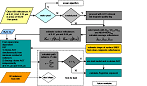
Aerosol research at STAR/SMCD/EMB primarily targets the development of physical algorithms for retrieving optical and microphysical properties of atmospheric aerosols utilizing measurements made from space by different, predominantly operational, Earth-observing satellites. (Read more ...)
NESDIS Aerosol Products
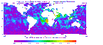 NOAA/NESDIS estimates aerosol optical depth from the Imager
instruments onboard the NOAA polar and geostationary platforms. The
products obtained from the polar orbiters are global, while those from
the geostationary satellites cover the contiguous US and surrounding
oceanic areas. (Read more ...)
NOAA/NESDIS estimates aerosol optical depth from the Imager
instruments onboard the NOAA polar and geostationary platforms. The
products obtained from the polar orbiters are global, while those from
the geostationary satellites cover the contiguous US and surrounding
oceanic areas. (Read more ...)