2017 Hurricane Season: IrmaHurricane Irma Moves Through the Caribbean - GOES-16 Full Color AnimationMost Recent 48-Hour Animation starting: 31 Dec 1999 - :: Z to: 31 Dec 1999 - :: Z 6 September 2017 - Hurricane Irma, currently approaching Puerto Rico and the Leeward Islands, is historic in size and strength, with maximum sustained winds of 185 mph and recorded gusts to 225 mph. In this view, Florida and the southeastern US are in the upper left, currently under cloud cover. The animation above is created with GOES-16 full color imagery updated every 15 minutes. Special thanks to RAMMB/CIRA and STAR IT for image animation and development support. NOAA's GOES-16 satellite has not been declared operational. Its data are preliminary and undergoing testing. Hurricane Irma - Approaching the Continental U.S. - GOES-16 Infrared Band 1348-Hour Animation starting: 31 Dec 1999 - :: Z to: 31 Dec 1999 - :: Z 6 September 2017 - As Hurricane Irma moves west and north in the next few days, this animation will capture its trajectory approaching the continental United States. It is just becoming visible in the lower right hand corner of the frame at 8:00 pm EST Wednesday. This animation shows GOES-16 images from infrared Band 13, refreshed every 5 minutes. Special thanks to RAMMB/CIRA and STAR IT for image animation and development support. NOAA's GOES-16 satellite has not been declared operational. Its data are preliminary and undergoing testing. Hurricane Irma - Detailed View of the Eye - GOES-16 Visible Band 2Animation from 5 September 2017, 1451 - 1736 UTC 6 September 2017 - This band 2 visible loop is zoomed in on the eye of Hurricane Irma. At this time, the eye is approximately 25 nautical miles in diameter. GOES-16's 500-meter resolution visible channel allows unprecedented views of the low- level clouds within the eye, including some mesovortices that can be seen rotating around the center axis. Credit and thanks to to RAMMB/CIRA and Dan Lindsey for this extraordinary view. NOAA's GOES-16 satellite has not been declared operational. Its data are preliminary and undergoing testing. Hurricane Irma - GOES-16 Infrared Band 13 AnimationMost Recent 24-Hour Animation starting: 31 Dec 1999 - :: Z to: 31 Dec 1999 - :: Z 5 September 2017 - Hurricane Irma, currently approaching Puerto Rico and the Leeward Islands, is historic in size and strength. It is currently moving westward toward Puerto Rico, the Dominican Republic, and Haiti. As of 2:00 PM AST the storm was reported to carry maximum sustained winds of 185 mph. See the NOAA National Hurricane Center for updates. The animation above is built with GOES-16 images updated every minute from infrared band 13. Special thanks to RAMMB/CIRA and STAR IT for image animation and development support. NOAA's GOES-16 satellite has not been declared operational. Its data are preliminary and undergoing testing. 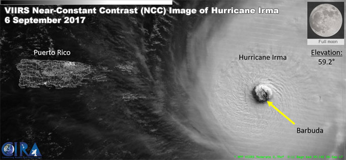
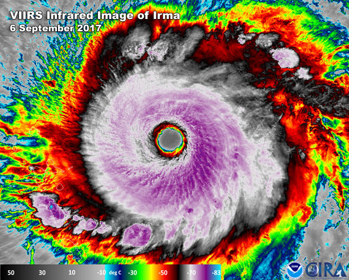
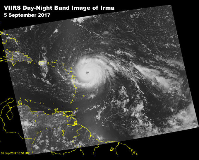
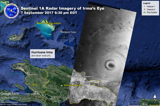
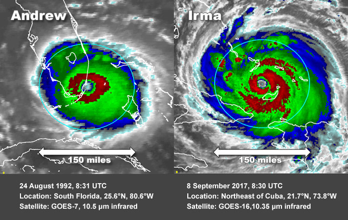
VIIRS Near-Constant Contrast DNB Image - 6 September 2017, 05:24 Z (9:24 am EST) Near-Constant Contrast (NCC) satellite image of Hurricane Irma at 0524Z, 6 September 2017 as it approaches Puerto Rico. The NCC is a derived product of the Day/Night Band sensor that utilizes a sun/moon reflectance model that illuminates atmospheric features, senses reflected and emitted light sources, and assists with cloud monitoring during the nighttime. In the image, notice the island of Barbuda is located in the eye-wall of the hurricane. In the top- right corner of the image, the moon percent visibility and moon elevation angle are provided. A full moon present and a positive moon elevation angle imply that the moon was above the horizon, and provided adequate reflected moonlight of the ambient atmospheric features. Thanks and credit: Jorel Torres (CIRA). Click images to enlarge. Sentinel Radar Image of Irma's Eye - 7 September 2017 6:30 pm EDT Sentinel-1A and Sentinel-1B are high-resolution radars from the European Space Agency. STAR radar imaging specialists work extensively with this data to extract geophysical information valuable to NOAA. Sentinel's radar can "see" through clouds and the radar image brightness (or backscatter) is the result of ocean surface roughness (on the scale of a few centimeters). The lower winds located in the hurricane's eye result in lower surface roughness and so appear darker than the surrounding (brighter) areas of higher winds. The image above shows a Sentinel overpass directly over Irma's eye acquired by Sentinel-1A on September 7, 2017, 6:30 pm EDT. Thanks and credit: Frank Monaldo and Christopher Jackson, STAR. Image contains modified Copernicus Sentinel-1 data from ESA. Click to enlarge image. Hurricane Andrew vs. Hurricane Irma8 September 2017, 8:30 UTC8 September 2017 - Infrared satellite image comparison of Hurricanes Andrew and Irma, using GOES-7 and GOES-16 images. The Andrew image was captured by GOES-7 at 10.5 µm on 24 August 1992, 8:31 UTC as Andrew made landfall near Miami. The Irma image came from GOES-16, 10.35 µm infrared band on 8 September 2017, 8:30 UTC, as Irma passed northeast of Cuba at 21.7°N, 73.8°W. Thanks and credit to John Knaff at RAMMB / CIRA. See more amazing tropical cyclone imagery for Irma and other storms at: Realis Time Tropical Cyclone Products. |
|
