Volume 1, Issue 2
January - March 2016
Blizzard of 2016
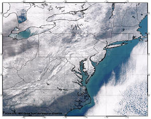
True Colors VIIRS Imagery shows the snowy aftermath of the Blizzard of 2016
(click to enlarge)
In mid-January, both European and US numerical weather
predication models began to show the possibility of a severe
winter storm that would impact the US East Coast. These
predictions came to fruition as the storm dumped 18+ inches of
snow over an area stretching from Kentucky to New York City on
January 23-24. Areas in West Virginia and western Maryland
received as much as 40 inches of snow,while most of major
northeastern cities approached or broke their previous snowfall
records.
STAR JPSS scientists have provided high resolution images and
product maps covering the impacts of this blizzard for the
Northeastern US. A webpage including the latest imagery can be
found at https://www.star.nesdis.noaa.gov/jpss/Blizzard2016.php.
This webpage allows for viewing and comparing the surface
conditions before and after Blizzard 2016. VIIRS visible imagery
and many JPSS products including the snow impacts on coastasl
turbidity are collected on the website.
GOES Evapotranspiration and Drought Product Operational Readiness Review and NESDIS SPSRB Operation Briefing
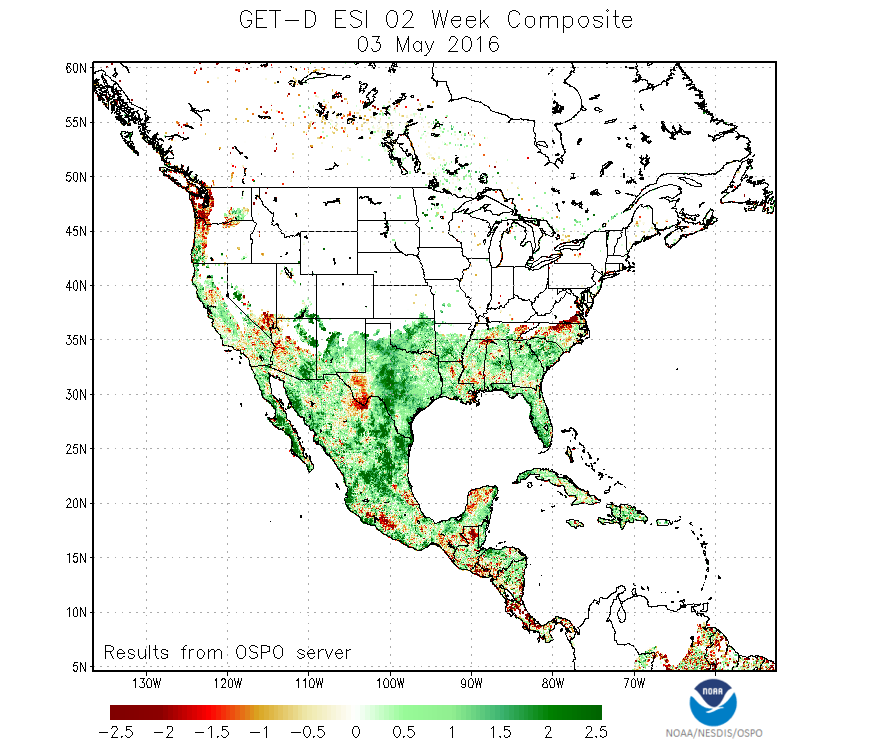
A sample map of the GET-D weekly composite product. Reds shot drier areas, and greens are wetter.
(click to enlarge)
After about two and a half years development, the GOES
Evapotranspiration and Drought Product (GET-D) System has passed
the Operational Readiness Review on February 5, 2016 and is
approved to go to operation by the SPSRB on February 17. The
GET-D system uses observations of solar insolation and land
surface temperature from NOAA GOES-East and GOES-West Imagers to
derive daily evapotranspiration over North America during clear
conditions. The daily evapotranspiration (ET) is needed for
validation of the ET simulations of the numerical weather
prediction models used by NCEP. The daily ET is further used to
derive an Evaporative Stress Index (ESI) which is an indication
of soil moisture status. Negative anomalies of ESI compared to
climatology are in turn indications agricultural drought. The
ESI drought monitoring products have been used to NCEP CPC
monthly drought briefing and the National Integrated Drought
Information System (NIDIS) that is currently the most used
drought information sources for the United State and the world.
The operational GET-D will provide NIDIS seamlessly with drought
information independent from almost all other drought
information sources. The GET-D system is developed by STAR
scientists and will be operational at OSPO.
GOES Fog Detection product imagery for the MATERHORN Project
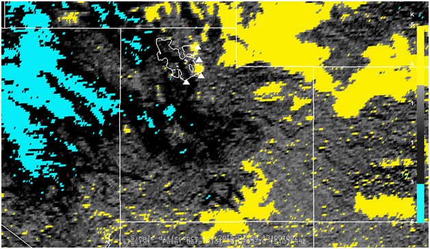
GOES Fog Detection product images at 1300 UTC January 9, 2015. Yellow shading (BTD < -2 K) represents fog while blue shading (BTD > 3 K) represents high-altitude ice (i.e. cirrus) clouds.
(click to enlarge)
K. Pryor has generated and delivered GOES Fog Detection
product imagery and datasets for an ice fog event over the Salt
Lake City metropolitan area that occurred on January 9, 2015 in
support of the Mountain Terrain Atmospheric Modeling and
Observations (MATERHORN) program. MATERHORN is a joint effort
between the Naval Postgraduate School, University of Notre Dame,
University of California, University of Utah, and University of
Virginia designed to investigate complex-terrain meteorology
over diverse scales, topography, and forcing mechanisms. During
this fog event, the GOES Fog product, derived from the
brightness temperature difference between GOES-15 band 2 (SWIR)
and band 4 (LWIR), effectively distinguished regions of fog from
regions of clear skies in the Salt Lake City area. Figure 2
shows fog detected by GOES near Salt Lake City International
("SLC") and Brigham City ("BMC") airports where visibilities were
observed to be less than two miles in fog at 1300 UTC. Near that
time at Ogden airport ("OGD"), no fog was indicated by GOES,
with a surface weather observation of clear skies and
unrestricted visibility.
Strong SMCD Participation in 96th AMS Annual Meeting

AMS 96th annual meeting logo
(click to enlarge)
January 11-14, 2015 - Members of SMCD as well as the
broader meteorological community gathered in New Orleans for the
AMS Annual Meeting. SMCD participation was strong, with 35 SMCD
employees presenting posters or oral presentations (along with
many more co-authors), and 4 sessions chaired by SMCD personnel.
In addition to these activities, four SMCD teams made
presentations on the main NOAA display screen in the exhibition
hall discussing ATMS, Aerosol, Land, and Soudings products. SMCD
is planning for better demonstrations of the JPSS and GOES-R
products and their applications in the future conferences
through charing the session, presenting the state-of-art remote
sensing algorithms and the product applications.
ATMS Post-Ship Review
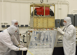
Ball Aerospace technicians lower the ATMS instrument onto the JPSS-1 spacecraft. Credit: Ball Aerospace & Technologies Corp..
(click to enlarge)
January 27 - SMCD Chief Fuzhong Weng
attended the JPSS-1 ATMS Post-Ship Review. In the meeting
representatives of the instrument designer, Northrop Grumann
presented a thorough review of assembly, including the
demonstration of instrument readiness for spacecraft
environmental test, the review of the instrument performance,
interfaces, and history,demonstration of instrument
requirements, and the review of waivers, open items, and
residual risks. In the review presentation the results of the
instrumental testing that includes bench, vibration, alignment,
EMI/EMC, thermal vacuum, noise, radiometric accuracy, and final
CPT were discussed.
Overall, all instrument level testing has been completed. The
issues identified in 2014 TVAC testing have been successfully
resolved. All instrument level key performance parameters have
been verified to meet the requirements. For all open issues
plans are in place for closure. It was also mentioned in the PSR
that the instrument has been delivered to the spacecraft and
successfully integrated for additional testing.
Committee on Earth Observation Satellites Land Surface Imaging Virtual Constellation planning meeting

CEOS logo
(click to enlarge)
Members of the CEOS Land Surface Imaging Virtual
Constellation team met during a planning teleconference to
discuss an upcoming meeting of the group (February 22-24, 2016,
Frascati, Italy) and the three-year work plan. Proposed goals
for the next year include; (i) Increase the visibility of land
surface imaging data holdings, (ii) Identification of
gaps/opportunities for acquisition in support of the CEOS carbon
Strategy, (iii) Definition of inter-comparable Analysis-Ready-
Data for land surface imaging, and (vi) Engage in the
implementation of trial Data Cubes.
EUMETSAT MTG-IRS Mission Advisory Group Topical Meeting on Level 1 Processing
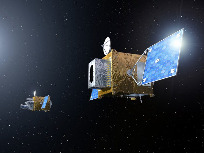
Artists rendition of Meteosat Third Generation/. Image courtesy of EUMETSAT
(click to enlarge)
Yong Han was invited to attend the Meteosat Third Generation
(MTG) Infrared Sounder (IRS) mission advisory group topical
meeting on Level 1 processing. He gave the presentation with the
title "CrIS Spectral and Radiometric Calibration". In this two-
day meeting, 20 presentations were presented by people mainly
from the EUMETSAT community, and discussions were focused on
issues related to instrument design, L1 processing algorithms,
data format and user requirements.
The main outcome is the document that summarizes the
recommendations and action items for the generation of level 1
IRS data with the level of quality required by the user
community. IRS is an imaging Fourier Transform spectrometer
based on a Michelson interferometer, two detector arrays
(160x160), a scan mirror. Each detector arrays covers 640x640
km2 with a single pixel size of 4 km2. The
instrument measures radiation in the two spectral bands: LWIR
(700-1210 cm-1) and MWIR (1600-2175 cm-1),
with a uniform spectral resolution 0.625 cm-1. The
first IRS onboard MTG will be launched into orbit in 2022.
ABI FM3 PSR
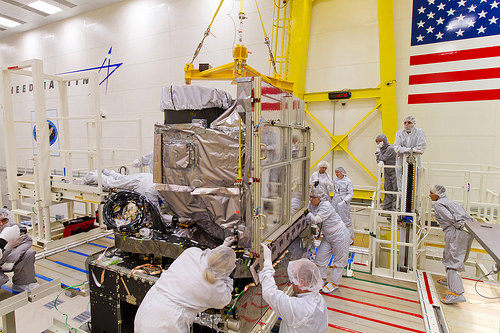
Installation of ABI FM1 onto GOES-R. FM3 will go on GOES-T. Image courtesy GOES-R Program.
(click to enlarge)
February 25 - The PSR for the ABI FM3 was
conducted at the Harris/Exelis facility in Ft. Wayne, IN. ABI is
a key payload for the GOES R-Series. X. Wu and B. Efremova,
members of the GOES-R Calibration Working Group, attended the
review and briefed the GOES-R Program Scientist prior to the
review on CWG assessment of ABI FM3 science performance. An
unprecedented section of this PSR was lessons learned from
Advanced Himawari Imager (AHI), a similar instrument launched in
October 2014 and currently operated by Japan Meteorological
Agency (JMA). CWG members were instrumental in promoting the
NOAA-JMA cooperation on advanced geostationary meteorological
satellite programs that enabled these lessons learned.
In particular, CWG led the discovery and characterization of
3.9 µm channel stray light that helped the identification of the
root cause and the timely correction for all ABI FMs. Overall the
Integrated Independent Review Team found that the instrument is
stable; verifications have nearly completed; lessons learned have
been properly applied; and the TVAC analyses were thorough.
NOAA Products Validation System Training at EUMETSAT
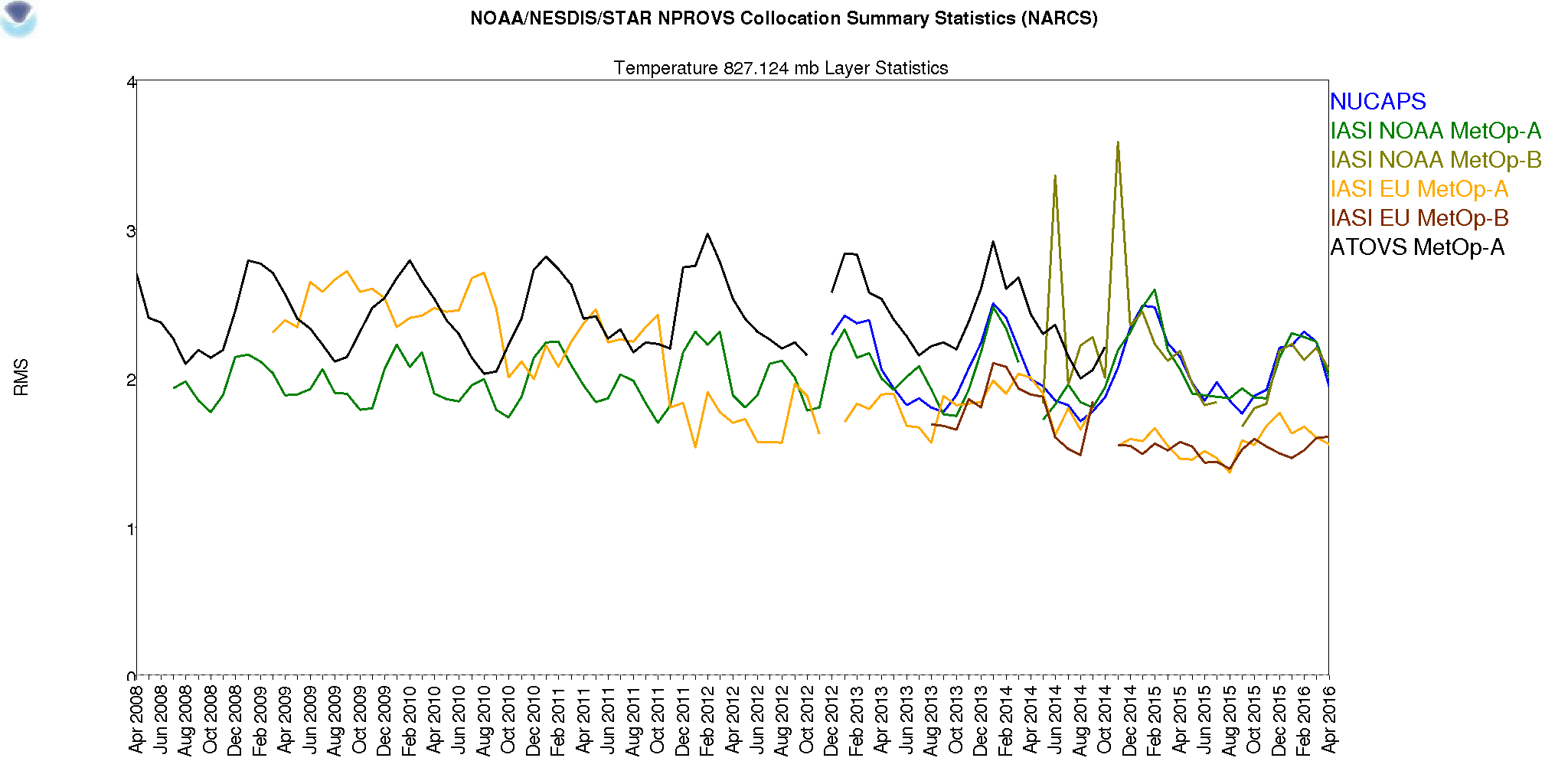
Sample plot from NPROVS showing comparisons between NUCAPS, IASI, and ATOVS at 827 mb over the time span of 2008-2015.
(click to enlarge)
February 22-26 - A.Reale was extended an
invitation by Dr. Thomas August, Hyper spectral Sounders Level 2
Team Leader, Remote Sensing and Sounding Division, to visit
EUMETSAT (Darmstadt, Germany) and provide training seminars on
conducting atmospheric profile validation using the NOAA
Products Validation System (NPROVS) developed and operated at
STAR. Training was also extended to staff participating in an
ongoing European Union Copernicus/Horizon-2020 Research and
Innovative Programme proposal entitled "Gap Analysis for
Integrated Atmospheric Environmental Climate Variable (ECV)
Climate Monitoring (GAIA-CLIM)" to which NOAA contributes as a
3rd party with a focus on satellite collocations with reference
observations from GCOS Reference Upper Air Network (GRUAN).
The training consisted of 2-days of training focused on
NPROVS+ applications relevant to GAIA-CLIM followed by 3-days of
training focused on applications relevant to EUMETSAT hyper
spectral sounder L2 products group. A photo of the core
participants in the training is shown in the panel below. A.
Reale also provided a general seminar to EUMETSAT staff on
Friday, 26 February. High interest was evident to leverage
NPROVS at EUMETSAT in ongoing projects focused on the analysis
of atmospheric temperature and moisture sounding (geophysical
and radiometric) from satellites and the ground, including
recommendation to consider establishing an NPROVS User Group
(NUG). Consideration for follow-up training in conjunction with
the planned EUMETSAT Satellite Conference and GCOS G-VAP Working
Group activities in Darmstadt later this year is pending.
CEOS Working Group on Cal/Val Plenary Meeting
Group photo of the attendees of the 40th Plenary Meeting of the CEOS WGCV
(click to enlarge)
The CEOS Working Group on Calibration/Validation (WGCV) will
hold its 40th plenary March 14-18 in Canberra, Australia,
sponsored by the Geoscience Australia and Commonwealth
Scientific and Industrial Research Organisation (CSIRO).
Changyong Cao will attend the meeting as the NOAA WGCV
representative and provide cal/val progress report. It is
expected that at the meeting, the latest status with recent
satellite launches such as Sentenel 3A will be discussed, as
well as progress in the radiometric calibration network sites. A
joint session with the Working Group on Information Systems and
Services (WGISS) is also on the agenda.
GSICS Annual Meeting
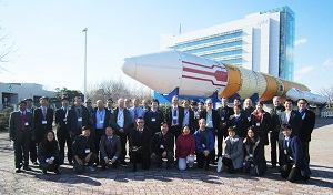
Group photo of the attendees of the Annual Meeting of the GRWG+GDWG.
(click to enlarge)
March 5, 2016 - Over 60 calibration scientists and researchers representing
almost all of the major meteorological and space agencies
operating Earth remote sensing satellite instruments attended
the GSICS Research Working Group and Data Working Group (GRWG
and GDWG) 2016 Annual Meeting at JAXA in Tsukuba and exchanged
information on new results, methods, and instruments. The first
day was taken up by a mini-workshop with emphases on the moon as
a calibration target and on calibration comparison results for
recently launched JAXA and JMA instruments. Major
accomplishments reported and discussed in the rest of the
meeting include the first operational products from EUMETSAT
and progress on new demonstration products from the Chinese
Meteorological Agency (CMA), the Korean Meteorological Agency
(KMA), and the Indian Meteorological Department (IMD).
Calibration comparisons using the Deep Convective Cloud (DCC)
method dominated the special session on visible sensors. NOAA
products will begin demonstrating this new approach. L. Flynn,
the GSICS Coordination Center Director and UV Subgroup Vice-
chair, provided four talks on the GCC Annual Report, defining
GSCIS products, the GSICS Users' Workshop and solar ultraviolet
References.
Committee on Earth Observing Satellites Working Group on Disasters Meeting
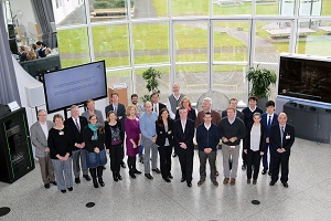
Group photo of the attendees of the CEOS DWG Meeting in Bonn, Germany.
(click to enlarge)
March 8-10, 2016 - B. Kuligowski attended
5th meeting of the CEOS Working Group on Disasters,
hosted by Deutsches Zentrum für Luft- und Raumfahrt (DLR) in
Bonn, Germany. As the co-chair of the Thematic Pilot for Floods,
he presented an update on Flood Pilot activities during the past
6 months and participated in discussions on how the activities
of the Pilot might be maintained after the Pilot period ends in
December 2017.
Importance: The purpose of this working group is to enhance the
use of earth observation (EO) data in disaster risk management by
strengthening the linkages among satellite data providers, the
creators of value-added products, and the potential users of those
products. Three pilot projects focusing on floods, seismic
hazards, and volcanoes are coordinating and leveraging ongoing
efforts to provide relevant EO data to users and to develop and
strengthen their capacity to use these data in decision-making; an
additional Pilot for landslides was recently initiated. In
addition, a recovery observatory has been created to improve the
use of EO data in longer-term recovery after a disaster occurs.
The intent is for these Pilots to lead to a sustained effort to
make better use of EO data in managing, responding to, and
recovering from flood disasters.
STAR JPSS Enterprise Algorithm Meeting
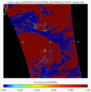
A sample of the Entireprise Cloud Mask output, which uses a 0-1 Cloud Probability scale, instead of the standard 4-level mask Warmer colors represent a higher probability of cloud cover in a given pixel..
(click to enlarge)
March 30-31, 2016 - STAR JPSS Management hosted the STAR
JPSS Enterprise Algorithms Workshop at NCWCP. Science teams and
corresponding stakeholders met to discuss current status of L2
JPSS products as well as their progress and plans toward
Enterprise Algorithm development. Identified risks and review
items will be compiled and circulated with the conference
report. Presentations are available at the conference website.

Bodeker, G. E., Bojinski, S., Cimini, D., Dirksen, R. J., Haeffelin, M., Hannigan, J. W., Hurst, D. F., Leblanc, T., Madonna, F., Maturilli, M., Mikalsen, A. C., Philipona, R., Reale, T., Seidel, D. J., Tan, D. G. H., Thorne, P. W., Voemel, H., & Wang, J. (2016). Reference Upper-Air Observations for Climate: From Concept to Reality. Bulletin of the American Meteorological Society, 97(1), 123-135. [10.1175/BAMS-D-14-00072.1]
Choi, T., Shao, X., Cao, C., & Weng, F. (2016). Radiometric Stability Monitoring of the Suomi NPP Visible Infrared Imaging Radiometer Suite (VIIRS) Reflective Solar Bands Using the Moon. Remote Sensing, 8(1). [10.3390/rs8010015]
Dai, Q., Han, D., Zhuo, L., Zhang, J., Islam, T., & Srivastava, P. K. (2016). Seasonal Ensemble Generator for Radar Rainfall Using Copula and Autoregressive Model. Stochastic Environmental Research and Risk Assessment, 30(1), 27-38. [10.1007/s00477-014-1017-x]
Gajbhiye, S., Meshram, C., Singh, S. K., Srivastava, P. K., & Islam, T. (2016). Precipitation Trend Analysis of Sindh River Basin, India, from 102-Year Record (1901-2002). Atmospheric Science Letters, 17(1), 71-77. [10.1002/asl.602]
Islam, T., Srivastava, P. K., Petropoulos, G. P., & Singh, S. K. (2016). Reduced Major Axis Approach for Correcting GPM/GMI Radiometric Biases to Coincide with Radiative Transfer Simulation. Journal of Quantitative Spectroscopy & Radiative Transfer, 168, 40-45. [10.1016/j.jqsrt.2015.08.016]
Jing, X., Shao, X., Cao, C., Fu, X., & Yan, L. (2016). Comparison between the Suomi-NPP Day-Night Band and DMSP-OLS for Correlating Socio-Economic Variables at the Provincial Level in China. Remote Sensing, 8(1). [10.3390/rs8010017]
Kogan, F., & Guo, W. (2016). Early Twenty-First-Century Droughts During the Warmest Climate. Geomatics Natural Hazards & Risk, 7(1), 127-137. [10.1080/19475705.2013.878399]
Obata, K., Miura, T., Yoshioka, H., Huete, A. R., & Vargas, M. (2016). Spectral Cross-Calibration of VIIRS Enhanced Vegetation Index with MODIS: A Case Study Using Year-Long Global Data. Remote Sensing, 8(1). [10.3390/rs8010034]
Rudlosky, S. D., Nichols, M. A., Meyers, P. C., & Wheeler, D. F. (2016). Seasonal and Annual Validation of Operational Satellite Precipitation Estimates. Journal of Operational Meteorology, 4(5), 58-74. [10.15191/nwajom.2016.0405]
Simons, G., Bastiaanssen, W., Ngô, L., Hain, C., Anderson, M., & Senay, G. (2016). Integrating Global Satellite-Derived Data Products as a Pre-Analysis for Hydrological Modelling Studies: A Case Study for the Red River Basin. Remote Sensing, 8(4), 279. [10.3390/rs8040279]
Srivastava, P. K., Yaduvanshi, A., Singh, S. K., Islam, T., & Gupta, M. (2016). Support Vector Machines and Generalized Linear Models for Quantifying Soil Dehydrogenase Activity in Agro-Forestry System of Mid Altitude Central Himalaya. Environmental Earth Sciences, 75(4). [10.1007/s12665-015-5074-3]
Stenz, R., Dong, X., Xi, B., Feng, Z., & Kuligowski, R. J. (2016). Improving Satellite Quantitative Precipitation Estimation Using GOES-Retrieved Cloud Optical Depth. Journal of Hydrometeorology, 17(2), 557-570. [10.1175/jhm-d-15-0057.1]
Sun, J., Madhavan, S., & Wang, M. (2016). Investigation and Mitigation of the Crosstalk Effect in Terra MODIS Band 30. Remote Sensing, 8(3). [10.3390/rs8030249]
Tang, F., Zou, X., Yang, H., & Weng, F. (2016). Estimation and Correction of Geolocation Errors in Fengyun-3C Microwave Radiation Imager Data. IEEE Transactions on Geoscience and Remote Sensing, 54(1), 407-420. [10.1109/tgrs.2015.2458851]
Wang, L., Tremblay, D., Zhang, B., & Han, Y. (2016). Fast and Accurate Collocation of the Visible Infrared Imaging Radiometer Suite Measurements with Cross-Track Infrared Sounder. Remote Sensing, 8(1). [10.3390/rs8010076]
Wang, W., & Cao, C. (2016). Monitoring the NOAA Operational VIIRS RSB and DNB Calibration Stability Using Monthly and Semi-Monthly Deep Convective Clouds Time Series. Remote Sensing, 8(1). [10.3390/rs8010032]
Xiao, Q., Zhang, H., Choi, M., Li, S., Kondragunta, S., Kim, J., Holben, B., Levy, R. C., & Liu, Y. (2016). Evaluation of VIIRS, GOCI, and MODIS Collection 6aod Retrievals against Ground Sunphotometer Observations over East Asia. Atmospheric Chemistry and Physics, 16(3), 1255-1269. [10.5194/acp-16-1255-2016]
Yin, J., Zhan, X., Zheng, Y., Hain, C. R., Ek, M., Wen, J., Fang, L., & Liu, J. (2016). Improving Noah Land Surface Model Performance Using near Real Time Surface Albedo and Green Vegetation Fraction. Agricultural and Forest Meteorology, 218, 171-183. [10.1016/j.agrformet.2015.12.001]
Zhang, R., Huang, C., Zhan, X., Dai, Q., & Song, K. (2016). Development and Validation of the Global Surface Type Data Product from S-NPP VIIRS. Remote Sensing Letters, 7(1), 51-60. [10.1080/2150704x.2015.1101649]
Zhou, L., Divakarla, M., & Liu, X. (2016). An Overview of the Joint Polar Satellite System (JPSS) Science Data Product Calibration and Validation. Remote Sensing, 8(2). [10.3390/rs8020139]
|

