AMSU Hydrological Product Climate Data Records (FCDR and TCDR)
Algorithm Description
Current passive microwave sounder data, used in hydrological applications, are derived from POES satellites for which the primary mission is operational weather prediction. These data are not calibrated with sufficient stability for climate applications. A properly calibrated FCDR needs to be developed over the entire time series of measurements from the same sensors on multiple satellites to enable the utilization of these data for long term studies. The FCDR accounts for sensor biases for a particular sensor on individual satellites, then contains intersatellite calibration to generate a homogeneous time series.
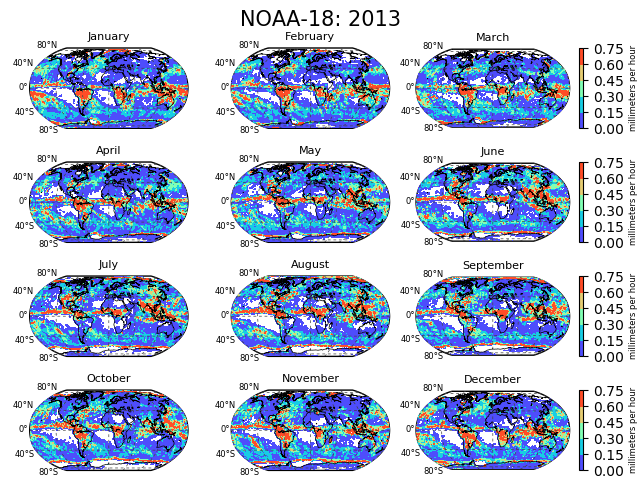
This product suite was developed under the auspices of NESDIS/National Center for Environmental Information (NCEI) Climate Data Record (CDR) program. It focuses on two sets of measurements from the NOAA and EUMETSAT AMSU-A and AMSU-B/MHS, specifically, brightness temperatures (TB) at 23.8, 31.4, 50.3, 89.0 (on AMSU-A) and 89, 150 (157), 183+1, 183+3 and 183+7 (190.7) on AMSU-B (MHS). These are denoted as Fundamental CDRs (FCDR). From these set of TBs, several hydrological products can be generated, including rain rate, snow water equivalent – these are denoted as Thematic CDRs (TCDR). The TCDRs are generated via algorithms from the Microwave Surface and Precipitation Products System (MSPPS). The MSPPS products include: rain rate, snowfall rate, total precipitable water, cloud liquid water, snow cover, snow water equivalent, sea ice concentration, ice water path, land surface emissivity (23.8 GHz, 31.4 GHz, and 50.3 GHz), and land surface temperature. Algorithms for the products are a series of physically-based retrieval algorithms; most recent update occurred in 2010, except for the snowfall rate, which was added about 5 years ago.
The AMSU Hydrological CDR time series is generated for NOAA-15, -16, -17, -18, -19 and Metop-A and spans the time period from 2000-2016; annual updates are generated with an approximate 1-year lag. The products are generated at CICS-MD and delivered via FTP push to NCEI. NCEI maintains the official archive of the data set and is equipped to run the products on their system in the future, as the software system was documented and transitioned to them in 2015.
Main Applications:
The FCDR data are useful as input into NWP reanalysis data sets as well as external users who rely on these channels to derive products. The TCDR data are most useful for stand-alone studies of diurnal variations of many products for the 17 year data period, as well as contributing components into merged satellite products.
Key Users:
- NOAA/NWS/NCEP/Climate Prediction Center and NASA/GPM program
Algorithm PI
Principal Investigator
Ralph Ferraro, NESDIS/STAR
Operational Product Access
STAR Monitoring and Algorithm Support
List of satellite/instruments for algorithm
- NOAA-15
- NOAA-16
- NOAA-17
- NOAA-18
- NOAA-19
- Metop-A AMSU-A
- Metop-A AMSU-B
- MHS

