VIIRS EDR Imagery
Algorithm Description
VIIRS Imagery is available from sun-synchronous polar-orbiting satellites, providing full-earth coverage every 12 hours (twice daily) due to its 3000 km wide swath from each pass.
VIIRS EDR Imagery consists of 3 main products:
- VIIRS I-band Imagery (5 bands @ 375 m spatial resolution).
- VIIRS M-band Imagery (16 bands @ 750 m spatial resolution (currently only 6 bands of which are available as EDR Imagery, although all bands/SDRs are potentially available as EDRs).
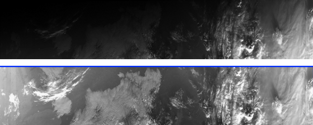
- VIIRS NCC Imagery (a pseudo-albedo product derived from DNB Imagery by compressing the 7 orders of magnitude DNB into 3 order of magnitude NCC) is a nearly constant contrast product both day and night and across the day-night terminator).
VIIRS EDR Imagery uses a Ground Track Mercator (GTM) remapping of the VIIRS SDR radiances or reflectances to produce the following advantages:
- Bowtie deletions and overlapping pixels at the edges of the VIIRS swath are removed, otherwise radiances/reflectances are identical to those in the VIIRS SDRs.
- NCC Imagery normalizes solar/lunar illumination, to create a product in which imagery appears similar brightness across the day-night terminator.

Top: DNB image across the day-night terminator; bottom: NCC image with nearly constant contrast across the day-night terminator.
Main Applications:
VIIRS EDR imagery is mainly a qualitative product, from which many other derived
image products can be created thru combinations/differences and three-color
(red-green-blue) combinations of single-band imagery.
Alaska and arctic/polar
users have a particular advantage in that the polar orbit allows multiple views each
day, as often as every orbit at the highest latitudes, resulting in much higher imagery
refresh rates than in non-polar locations.
Currently two operational satellites
(S-NPP and NOAA-20) provide VIIRS imagery at 50 minute separation between the satellites,
two views per satellite, one during the day and one at night at approximately 0130 and
1330 local time.
Key Users:
- National Weather Service (thru SBN/NOAAport to AWIPS2)
MiRS key users include the National Hurricane Center (NHC) who utilizes the an algorithm for tropical cyclone intensity estimates that use as inputs MiRS profiles of temperature and water vapor. NHC also uses the Blended TPW and Layer Water Vapor products which are derived from inputs of MiRS water vapor profiles. The Weather Prediction Center also uses both Blended TPW and Layer Water Vapor in their operational forecasting activities. The Climate Prediction Center uses MiRS precipitation rate in their global high resolution blended precipitation analyses (CMORPH) that are updated every 30 minutes.
Algorithm PI
Principal Investigator
Don Hillger, NESDIS/STAR/RAMMB
Operational Product Access
GRAVITE/IDPS, as well as Direct Broadcast to equipped earth locations.
STAR Monitoring and Algorithm Support
Other Relevant Links
List of satellite/instruments for algorithm
- S-NPP ATMS
- NOAA-20

