SMCD EMB Drought Monitoring Site
Product Repository
 This STAR Evaporative Stress Index (ESI) for drought monitoring
page provides information about the NESDIS Geostationary
Evapotranspiration and Drought (GET-D) product system and its
Evaporative Stress Index (ESI) data products.
The NESDIS GET-D system was developed at NOAA-NESDIS to generate daily land surface evapotranspiration (ET) for numerical weather prediction (NWP) model verification, calibration and data assimilation. Evapotranspiration is the water evaporated from soil and plant surface plus water transpired from plan leaves into the atmosphere. Because evaporation and transpiration convert part of the net radiation energy received by land surface into the atmosphere as latent heat flux, ET or latent heat flux is one of the most important variable of NWP models. ET observations are thus one of the most important data sets required for NWP model validation, calibration and data assimilation.
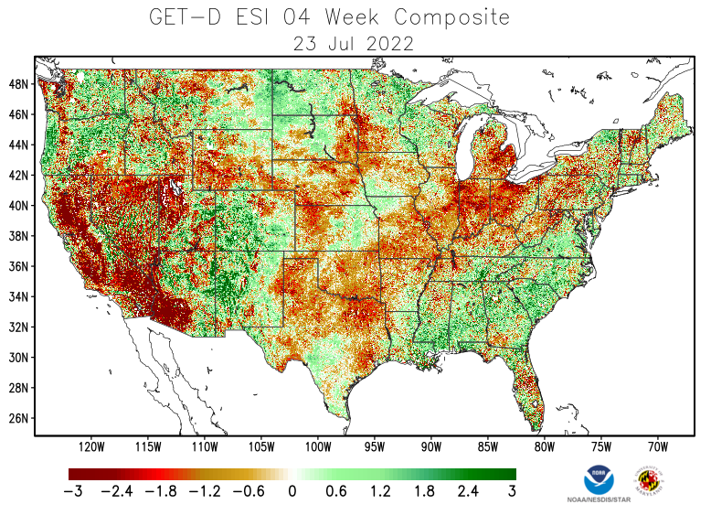
In the GET-D system, ET is retrieved via energy balance using remotely sensed land-surface temperature (LST) time-change signals from NOAA Geostationary Satellites (GOES). LST is a fast-response variable, providing proxy information regarding rapidly evolving surface soil moisture and crop stress conditions at relatively high spatial resolution. The Evaporative Stress Index (ESI) from GET-D system describes temporal anomalies in evapotranspiration (ET), highlighting areas with anomalously high or low rates of water use across the land surface. Thus, the areas with negative ET anomalies or low rates of water use (usually highlighted with red color) indicate drought occurrence. The ESI also demonstrates capability for capturing early signals of “flash drought," brought on by extended periods of hot, dry, and windy conditions leading to rapid soil moisture depletion. Details on how GET-D system generates ET and ESI data products could be found from the GET-D system Algorithm Theoretical Basis Document (ATBD), (PDF, 1.92 MB). Science details of the GET-D system were described in Zhan et al (2021).
The NESDIS GET-D product system was operational using NOAA GOES-13/15 observations. It stopped operation after January 8, 2018 when NOAA switched primary operational geostationary satellites from GOES-13 to GOES-16 which uses the Advanced Baseline Imager with better spatial and spectral resolutions. To use ABI observations, GET-D has been upgraded to generated ET and ESI for CONUS with 2km spatial resolution instead of the previous 8km under a NASA ROSES research project. Preliminary ESI data products are posted with this webpage. Science and software architecture details of the upgraded GET-D product system are published in Fang et al (2019) & Fang et al (2022).
