About
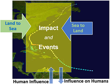
Components of coastal impacts
Warming oceans, seawater acidification, sea level rise, and other long-term environmental changes are part of the ongoing climate crisis that impacts the coasts. Episodic natural events, such as storms, flooding, and harmful algal blooms (HABs), also endanger the lives and livelihood in coastal communities. Similarly, our land use and presence along the coast affect the coastal ecosystem’s processes and health. These challenges are further compounded by the dynamic and complex coastal regions that are challenging to study. Consequently, understanding them and the processes and events within them necessitates a holistic, integrated approach that incorporates a variety of information, including that only available from satellite observations.
The Application Knowledge Hub (AKH) was created by the Center for Satellite Applications and Research of the National Oceanic and Atmospheric Administration's (NOAA) Satellite and Information Service in collaboration with the Committee on Earth Observation Satellites' (CEOS) Coastal Observations Applications Services and Tools (COAST) and other partners. Its purpose is to provide a knowledge hub that maximizes using satellite-based observations to illustrate and visualize the impact of climate change and episodic events. The goal is to contribute to coastal ocean awareness, safety, and restoration efforts.
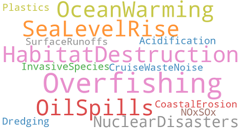
Threats to coasts and to coastal communities
Focus Area (initial)
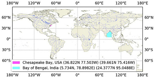
Chesapeake Bay, Bay of Bengal, and Global
The CEOS COAST AKH is global in scope, yet there is a strong regional focus by
taking advantage of high-resolution satellite data and contextual information.
Following the CEOS COAST goals, we initially will focus on the coasts
surrounding the US Chesapeake Bay and the Indian Bay of Bengal coasts.
The AKH will expand to other coasts and small island nations.
For the Bay of Bengal area, we are actively collaborating with ISRO's Space Application Centre (SAC). More details are coming...
For the Chesapeake Bay, NOAA STAR’s Satellite Oceanography and Climatology Division (SOCD) will continue its partnership with NOAA’s North Atlantic Regional Collaboration (NART) team to develop and evaluate satellite-derived data products. The hub will be a virtual toolbox of indicators to enhance partners’ understanding of communities along its shore and their vulnerability to flooding and water quality impacts.
Infographic
The AKH ingests satellite and non-satellite info (see Data section). Conceptual output types are listed here.
Display type
Map visualization, Timeseries of station data, Event maps (future)
Trends in ocean parameters (work underway)
Sea surface temperature, Chlorophyll-a, Sea level anomaly, Wind magnitude
Prediction for various Representative Concentration Pathways (RCPs) (Nature paper; external)
Episodic flooding due to storm events, Sea level rise (IPCC AR6)
Multidimensional analysis (future work)
Spectral analysis, Machine learning (e.g., Support Vector Machine)
Despite the known limitations in satellite capabilities for coastal applications, with improved sensor characteristics, they are attractive enough to be explored in conjunction with other available information to get the best value from an integrated approach and create a value chain for coastal awareness and applications.
Satellite data alone is insufficient for this task but provides the necessary
backbone. However, integrating a vast amount of satellite and non-satellite
observations (in situ, coastal classification, social indicators), advanced
mathematical methods to compute derivative information (e.g., trends and
shoreline changes), and modern visualization provide an opportunity to
understand coastal changes.
Currently, this is work in progress. The hub is in its
early days (beta). We will seek feedback soon as we
capture a few checkpoints.
Data
The AKH is designed to simultaneously display the following information:
- Satellite-based Ocean Parameters (e.g., SST, Chl-a)
- Basemaps (e.g., Natural Earth) and Reference Layers (e.g., Admin Boundaries)
- Trends in Ocean Parameters (coming soon)
- US Social Indicators (e.g., Vulnerability)
- SAV Habitat Suitability Index (HSI), Chesapeake Bay
- US Regional Land Loss/Gain (Mobjack Bay)
- Station Measurements (standard ocean and meteorological parameters)
- Elevation
- Waterways
- Hydrosheds
- Dams and Reservoirs
- Ecology (e.g., seagrass, mangroves)
- Ecological Coastal Units
- Exclusive Economic Zones
- Projection of Episodic Extreme Events for various RCPs
- Bathymetry (future)
- US Coastal Land Cover Land Use
- A set of curated major coastal events that caused significant damage (e.g., storms)
The data sources, grouped contextually, are given below.
- NOAA SOCD science teams via CoastWatch
- NASA WorldView (JPL)
- EU CMEMS
Chlorophyll-a, Sea Surface Height, Sea Surface Salinity, Sea Surface Temperature, Wind Magnitude
- JPSS/VIIRS product suite NOAA
- NASA WorldView
VIIRS/ABI Merged Water Detection, IMERG Precipitation
- NASA WorldView
VIIRS True Color, NPP Day-Night ENCC, SNPP Night Blackmarble, Sentinel-2A/B MSI Reflectance, Terra MODIS True Color
- NaturalEarth (base layers)
Shaded Relief, Gray
- NASA WorldView (reference layers)
Coastlines, Place Labels, Administrative Boundaries
- NCEI IbTracs
Global collection of tropical cyclones available; post-processed delayed mode of high-quality
- NDBC (realtime, historical)
Standard Meteorological, Water Quality, Tsunameter
- USGS (hyperlinked)
Estuary, Wetland, Coastal, Shore, Sewer, Atmosphere, Stream, Lake, Canal, Well
- HydroSHEDS
- USGS
- OSM/University of Tokyo
- SEDAC/CIESIN, Columbia University
Waterways, Hydrosheds, Dams, Reservoirs
- National Marine Fisheries Service
- SEDAC/CIESIN, Columbia University
US Social Vulnerability Indicators (multi-layer info), Human Base
- NOAA, Office for Coastal Management, Digitalcoast
- OSM/University of Tokyo
US Land Cover Land Use (LCLU), Digital Elevation Model (DEM)
- Comm. for Env. Coop. (CEC) Blue Carbon
Seagrass, Mangroves, Salt marshes (North America)
- UN Env. World Conservation Monitoring C.
Seagrass, Mangroves, Salt marshes (Global)
- USGS
USGS Ecological Coastal Units (ECU)
- Marine Regions Org
Exclusive Economic Zone boundaries with type classification
- Trends in ocean parameters (ongoing)
- Land loss/gain, Mobjack Bay
- Habitat Suitability Index, Chesapeake Bay (coming soon)
- Extreme Sea Level Projection for different RCPs (external)
Based on reasearch work (to be published, peer-reviewed)
Technology
The AKH employs a client-side web architecture.
Web Design
HTML5, JS, Jquery, CSS, Bootstrap, AOS, PopperJS, IntroJS and more.
Raster Tiling
A modified version of NASA GSFC/JPL Meta Raster Format (MRF) implemented in NOAA OceanView.
Vector Handling
- Smaller sized files (< 5Mb) use GeoJSON technology
- Larger sized files (could be 10+ Gb) use Vector Tiling in Google Protobuf
Advanced Computation
- For understandng signals, Fourier Transform, Wavelet analysis, and PCA etc. are used, as is appropriate.
- Longterm data are handled in Xarray
- Vectorized computations are employed when needed
People and Partners
The AKH is a collaborative approach between CEOS COAST, NOAA, ISRO, and other partners. The full list will be included shortly.
Development
Paul DiGiacomo
Principal Sci. Advisor for STAR Chief, Satellite Oceanography and Climatology Division
Prasanjit Dash
CIRA Research Scientist IIIExpert Contributions

Rachel Lazzaro
Research Scientist, GST, Inc.
Nikolay Nezlin
Research Scientist, GST, Inc.
Christopher W. Brown
Visiting Research Scientist
Megan Coffer
Research Scientist, GST, Inc.
SeungHyun Son
Research Scientist, ESSIC, Univ of MDPartners
Name Surname
Position descriptionName Surname
Position descriptionName Surname
Position descriptionName Surname
Position descriptionContact
If you have further interest, feel free to contact us.
Location:
NOAA NESDIS STAR, NCWCP, MD, USA
Email:
paul.digiacomo@noaa.gov (vision and objective)
prasanjit.dash@noaa.gov (implementation and data)
