
Near Real-time Altimetry
NOAA/NESDIS LSA CryoSat Interim Geophysical Data Record (IGDR)
 Since 9 December 2011, the NOAA/NESDIS Laboratory for
Satellite Altimetry has been producing Level-2 near-real-time ocean wind
speed, wave height, and sea surface height anomaly data from the European
Space Agency's CryoSat mission. We retrack ESA's low-rate mode
Level-1B products to generate Interim Geophysical Data Records (IGDRs)
approximately 2 days after real time. These are intended for use in
medium-range weather forecasting, seasonal forecasting, and ocean weather
applications.
Since 9 December 2011, the NOAA/NESDIS Laboratory for
Satellite Altimetry has been producing Level-2 near-real-time ocean wind
speed, wave height, and sea surface height anomaly data from the European
Space Agency's CryoSat mission. We retrack ESA's low-rate mode
Level-1B products to generate Interim Geophysical Data Records (IGDRs)
approximately 2 days after real time. These are intended for use in
medium-range weather forecasting, seasonal forecasting, and ocean weather
applications.
The IGDRs can be obtained in NetCDF format from either the LSA anonymous ftp site or the Radar Altimeter Database System (RADS). At present new IGDRs will be released each day at approximately 20:50 UTC. For more information on the CryoSat mission, please visit ESA's website.
We would like to acknowledge the generous support of ESA, CNES, and ECMWF for making it possible for us to create these products.
Technical Notes
Please see the technical notes, (PDF, 56 KB) for processing and data latency details.
References
- Retracking CryoSat waveforms for Near-Real-Time ocean forecast products and platform attitude, (PDF, 10.69 MB)
- Retracking range, SWH, sigma-naught, and attitude in CryoSat conventional ocean data
- Near-Real-Time Wave, Wind, and Sea Surface Height from CryoSat FDM/L1B data
- Validation of Retracked CryoSat Data Over Open Ocean
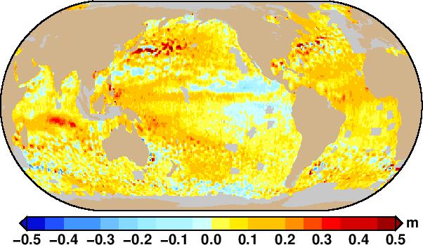
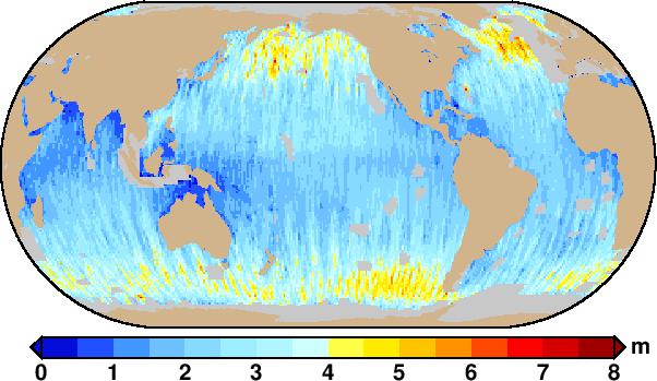
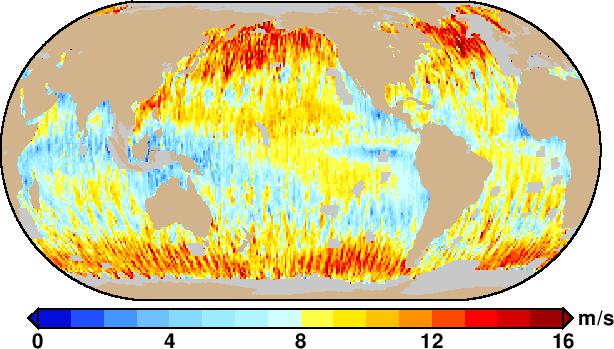
Maps from the NOAA CryoSat IGDRs for 17 November to 13 December 2011
| Sea level anomaly |
|---|
 |
| Significant wave height |
 |
| Wind speed |
 |
Radar Altimeter Database System
 The Radar Altimeter Database System
(RADS) is an effort of the Department of Earth Observation and Space
Systems (DEOS) at TU Delft and the NOAA Laboratory for Satellite
Altimetry to establish a harmonized, validated, and cross-calibrated sea
level data base from satellite altimeter.
The Radar Altimeter Database System
(RADS) is an effort of the Department of Earth Observation and Space
Systems (DEOS) at TU Delft and the NOAA Laboratory for Satellite
Altimetry to establish a harmonized, validated, and cross-calibrated sea
level data base from satellite altimeter.
Data Use Policy
LSA data are distributed at no cost to the users to promote scientific utilization of the data with the stipulation that the users of the data agree to follow the policy described below:
- LSA data are produced on a best effort basis.
- In publications, presentations, or on web pages
based on LSA data the following acknowledgment should be included.
"Altimetry data are provided by the NOAA Laboratory for Satellite Altimetry."