 Branch/
Laboratory for Satellite Altimetry")
Ocean Topography and Cryosphere (OTC) Branch/ Laboratory for Satellite Altimetry (LSA)
Radar Altimeter Database System (RADS)
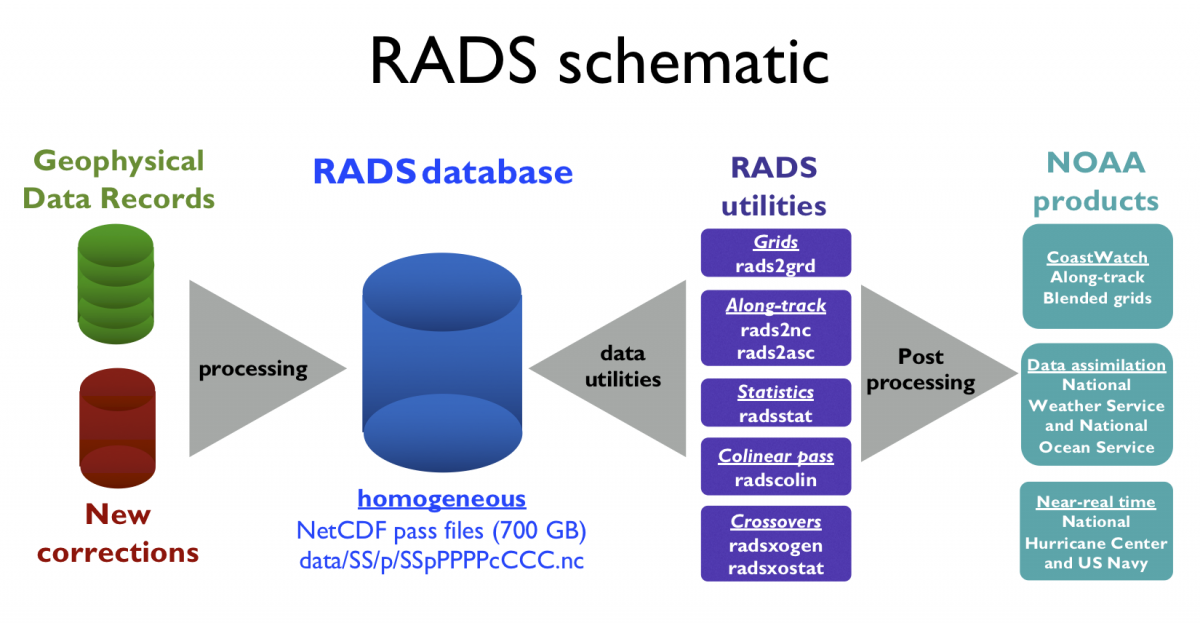
The Radar Altimeter Database System (RADS) is employed at NESDIS/STAR as an enterprise multi-mission algorithm providing consistent sea level anomaly, waves, and ocean surface wind speed products. RADS was originally designed as a database tool for expert altimetry users but through NOAA CoastWatch and LSA training materials, but can be used at both expert and entry levels: advisory councils, water management authorities, teachers, and students. RADS is a joint effort of the NOAA Laboratory for Satellite Altimetry (LSA), EUMETSAT, and Department of Earth Observation and Space Systems (DEOS) at the Delft University of Technology.
RADS uses a consistent set of corrections to produce homogenized data from multiple missions (over a dozen, currently) that in turn are used to generate Level-2P products for operational users, including data assimilation at NOAA, NASA, and the US Navy (e.g. the Global Real-Time Ocean Forecast System (Global RTOFS) and the West Coast Operational Forecast System) and Level-2P and Level-3 products distributed through NOAA CoastWatch (Sea Level Anomaly and along-track altimetry). Near-real-time RADS files are supplied to the National Hurricane Center. RADS is also used as a calibration/validation platform for Jason-3, Sentinel-3, and Sentinel-6.
The RADS database is a collection of continually updated NetCDF datasets. Geophysical Data Records and associated corrections are processed and stored in homogenized NetCDF pass files. Near real-time processing is done two times per day at NOAA for the following missions: Jason-3, Sentinel-3A, Sentinel-3B, AltiKa/SARAL, and CryoSat-2. Reprocessing is done jointly with EUMETSAT. These files are then used to generate higher-level products using the RADS data utilities and other algorithms.
Publications:
Recent publications that have used RADS data and utilities can be found in RADS publications.
Citation:
Scharroo, R., E. W. Leuliette, J. L. Lillibridge, D. Byrne, M. C. Naeije, and G. T. Mitchum, RADS: Consistent multi-mission products, in Proc. of the Symposium on 20 Years of Progress in Radar Altimetry, Venice, 20-28 September 2012, European Space Agency Special Publication, ESA SP-710, p. 4 pp., 2013.
Documentation:
There are two manuals that cover the use of the RADS software and the contents of the RADS data base:
RADS User Manual The user manual describes step-by-step installation and configuration details, command-line tool/utilities usage/syntax, and the RADS library (a Fortran90 module providing the main functionalities for the RADS4 software).
RADS Data Manual The data manual describes the details of variables used in the RADS database.
The RADS Utilities page describes additional support offered by NOAA CoastWatch.
RADS requirements:
- Software installation (Unix/Linux/macOS, suitable VM with Fortran 90 compiler). Available at GitHub
- Synchronized mirror of NetCDF pass files. NOAA hosts the RADS data base at https://www.star.nesdis.noaa.gov/pub/sod/lsa/rads/data/