
STAR / SMCD / EMB Radiation Budget
NESDIS Radiation Budget Products
This site provides a brief overview of the operational radiation budget data produced at the National Environmental Satellite, Data, and Information Service (NESDIS) of the National Oceanic and Atmospheric Administration (NOAA). Depending on the type of the satellite orbit there are two products. They are radiation budget data from geostationary satellites and from polar satellites.
Radiation Budget Data from Geostationary Satellites
 NOAA/NESDIS has been providing radiation budget data from geostationary satellites operationally since 1996.
The data are derived from measurements made by the imager instruments onboard the geostationary satellites,
and are made available in the Geostationary Surface and Insolation Product (GSIP).
The primary GSIP radiation products are the total solar radiation and the photosynthetically active radiation
(PAR) at the surface. Principle clients of this product are users of the NOAA/HotSpot product suite;
NCEP and the hydrology community. In addition to the primary products, GSIP also contains data on clouds,
surface temperature, longwave and solar radiation at the top of the atmosphere and at the surface.
NOAA/NESDIS has been providing radiation budget data from geostationary satellites operationally since 1996.
The data are derived from measurements made by the imager instruments onboard the geostationary satellites,
and are made available in the Geostationary Surface and Insolation Product (GSIP).
The primary GSIP radiation products are the total solar radiation and the photosynthetically active radiation
(PAR) at the surface. Principle clients of this product are users of the NOAA/HotSpot product suite;
NCEP and the hydrology community. In addition to the primary products, GSIP also contains data on clouds,
surface temperature, longwave and solar radiation at the top of the atmosphere and at the surface.
Solar Resource Data Base
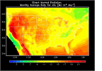 The first version of Geostationary Surface and Insolation Product (GSIP-v1) data served as the basis
for the Solar Resource Parameters available here. These parameters
are provided for the contiguous US and thought to be useful in assessing solar energy available at the surface.
The first version of Geostationary Surface and Insolation Product (GSIP-v1) data served as the basis
for the Solar Resource Parameters available here. These parameters
are provided for the contiguous US and thought to be useful in assessing solar energy available at the surface.
Radiation Budget Data from Polar Satellites
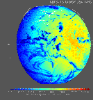
NOAA/NESDIS has been routinely estimating radiation budget at the top of the atmosphere from the Advanced Very High Resolution Radiometer (AVHRR) onboard the NOAA polar orbiting operational satellites. The products are global daily, monthly, seasonal, and annual averages of absorbed solar and longwave emitted (Outgoing Longwave Radiation, OLR) radiation in one-degree equal area grids. Radiation budget data produced by NOAA/DESDIS is archived at and can be obtained from the NOAA Comprehensive Large Array-data and Stewardship System (CLASS) .