Ocean Topography and Cryosphere (OTC) Branch/ Laboratory for Satellite Altimetry (LSA)
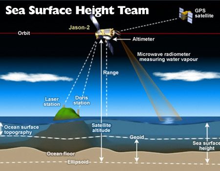
The NOAA/STAR Laboratory for Satellite Altimetry (LSA) housed in the Ocean Topography and Cryosphere Branch specializes in the application of satellite altimetry to a broad array of climate and weather related issues, including global and regional sea level rise, coastal and open-ocean circulation, weather prediction — from hurricane intensity forecasting to El Niño and La Niña events -- and monitoring the changing state of the Arctic Ocean. LSA hosts the NOAA Jason/Sentinel-6 Science Program, Sea Surface Height Science Team, and the Sea Ice and Polar Dynamics Science Team.

The Sea Ice Science Team is composed of
participants from the STAR/SOCD Laboratory for Satellite Altimetry, the U.S. National
Ice Center, and external collaborators from academia. In addition to remote sensing
research on sea ice characterization and applications development, the team is
interested in other cryospheric topics including snow over sea ice and land, lake
ice, icebergs, and ocean-ice shelf interaction. The team also contributes leadership
and expertise to the international Arctic and Antarctic buoy programs and provides
advice to NOAA, Navy, the U.S. Coast Guard and other agencies on global cryospheric
issues with particular focus on the development and implementation of strategies for
the Arctic region. Sites include: National
Ice Center, MASIE, and Sea Ice and Polar Dyanamics Site.
Hover to pause slides

