NOAA STAR Integrated Calibration/Validation System (ICVS)
About ICVS
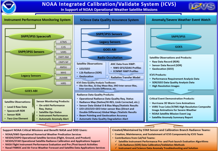
- Integrated Calibration and Validation System (ICVS) is an operational system that supports NOAA's weather satellite missions by monitoring and evaluating the Near-Real-Time (NRT) status, performance, and science data quality of satellite instruments.
- ICVS is a mission-critical tool for the calibration and validation of satellite instruments, specifically supporting the quality assurance of Level 1b (L1b) or Sensor Data Records (SDRs). It is used by the NESDIS/STAR Cal/Val SDR science team, NESDIS/OSPO, NOAA/NWS, NASA, the U.S. Air Force, the Naval FNMOC and NAVO, as well as international satellite data users such as ECMWF and EUMETSAT.
- ICVS integrates data from all NOAA operational weather satellites, including those on the Suomi National Polar-orbiting Partnership (SNPP), Joint Polar Satellite System (JPSS), NOAA's legacy Polar Operational Environmental Satellites (POES), and Geostationary Operational Environmental Satellites (GOES). This integration ensures the satellite science data remain highly consistent and traceable across a constellation of global satellites observations in both Low Earth Orbit (LEO) and Geostationary Earth Orbit (GEO).
ICVS Key Components
- Near-real-time monitoring modules for the health status and performance of NOAA operational weather satellites (JPSS, GOES, and legacy POES) and their onboard instruments, along with an automatic alert system for spacecraft and instrument anomalies.
- Near-real-time monitoring modules for the quality of NOAA operational weather satellite science data product (L1b radiance, TDR/SDR, and GEO), including tools for monitoring quality flags, observation-simulation (Obs-Sim) biases, and LEO-LEO/LEO-GEO inter-satellite and inter-sensor bias evaluations, as well as an automatic alert system for radiance/SDR data quality degradation.
- Monitoring of severe weather events, such as hurricanes, head domes, volcanoes, and others, using near-real-time satellite observations from NOAA operational weather satellites.
ICVS Highlights
- Monitoring over 30 instruments aboard multiple satellites, with more than 6000 monitoring products updated in near real time through ICVS website to support NOAA critical missions since the launch of Suomi NPP in 2011.
- Supporting rapid instrument anomaly troubleshooting and resolutions by instrument scientists and engineers through various instrument status and data quality monitoring products.
- Capturing major global events, such as hurricanes, volcanoes, heatwaves, and more, in near real time using SDR imagery, animations, and other satellite data.
- Providing a platform for pre-launch readiness activities for future LEO satellite missions (e.g., QuickSounder, JPSS-3, JPSS-4, et. al.).
- Providing a platform for end-of-life evaluations for satellite instruments slated for future decommissioning.
Disclaimer:
Contents on this site do not constitute a statement of policy, decision, or position on behalf of NOAA or the U.S. Government.