
STAR / SMCD / OPDB - NOAA Products Validation System (NPROVS) - NPROVS
Download the program
Last Updated: 10/31/2025
Download ODS Version (7.23) Click on the link and then choose where to save the file, recommend in a folder.
*** NOTE: Beginning with version 7.18, it is necessary to include two external libraries within a "lib" directory that is in the same directory as ODS.jar. If these libraries are not present, ODS will create them and then display a dialog box that will say that the program needs to be restarted. At that point, close the dialog box and restart the program to resume normal operation.
Download the files
The most recent 5 days of data for every system that is used by NPROVS are available via FTP. For any available file, click on the link and then choose where to save the file.
ODS Overview
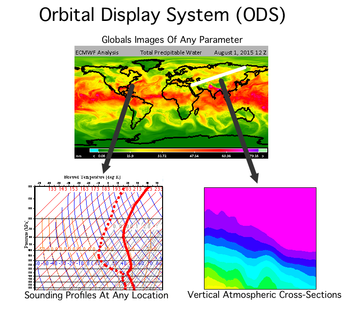
The primary purpose of the NPROVS Orbital Display System (ODS) is to display images that show data from every satellite that is input into the NPROVS system. For each system, all parameters that are produced by the system can be displayed. The images that are produced by ODS can be altered to display the data in a variety of ways.
The images produced by ODS are only a starting point. Using ODS, it is possible to dig deeper into the data. If the file from which the data are generated contains sounding profiles, then any location on the image can be selected to view all temperature and moisture sounding profiles at the selected location. In addition to the profiles, raw data, such as quality flags, that are associated with the selected location are displayed.
The availability of sounding data also provides the ability to view vertical cross-sections of the atmosphere. Simply turn the cross-section option on and draw a line across an image to create a vertical cross-section of the atmosphere along the line. The cross-section will contain data for all available temperature and moisture profiles.
Yet another useful feature of ODS is the ability to compare data. Differencing can be applied to any two images. The resulting image will show the difference between each pixel in both images by subtracting the second image from the first image. The image above shows this feature. The difference image on the right shows the result of the second image subtracted from the first. In this example, it is easy to see where the first image is warmer (red areas) and where the first image is colder (blue areas).
Available Systems
Data from many processing systems are currently available for downloading and viewing. The following is only a partial list of the available systems. Many of the following include data from multiple spacecraft and from operational and test systems:
|
|
Installing and Running ODS
ODS is a Java program. As such, it can be run on any system on which Java has been installed including Windows, Mac OS X, Linux and others. Installing the program is typically as simple as copying the ODS.jar file (linked above) to a folder on a local computer. The icon can then be double-clicked to run it.
More information about running ODS can be found in the ODS User's Guide and the ODS Quick Start Guide