Laboratory for Satellite Altimetry / Sea Ice and Polar Dynamics Science Team
 IceBridge 2010 Flights
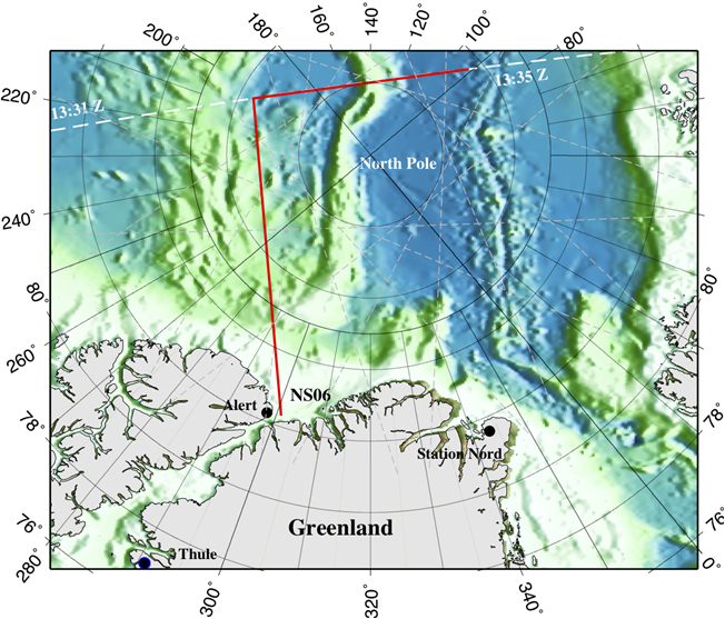
CryoSat-2 ground-track (dashed white) and IceBridge DC-8 track (L- shaped, red). The April 20 sea ice survey began at NS06 flying north to and along the CryoSat-2 track. CryoSat-2 overpass times (GMT) on April 20, 2010 are shown in white. DC-8 flew back and forth along the CryoSat-2 track between 13:47 and 15:58 GMT

Arctic Sea Ice, seen from the NASA DC-8
Photo credit: Michelle Williams, NASA
The LSA/Sea Ice Research Group (SIRG) members are serving on the ad-hoc science team which helped plan NASA's IceBridge Mission Arctic sea ice flights in March and April, 2010 on the DC-8 aircraft out of Thule, Greenland. Two days of particular NOAA/LSA interest are:
- April 5, 2010: NASA DC-8 under-flew ESA's Envisat along the same ~1200 km-long Envisat groundtrack segment flown on Mar 27, 2006 in the Canada Basin (AAA Validation Experiment). This is the third successful underflight and validation of Envisat altimeter data over sea ice in this region.
- April 20, 2010: LSA/SIRG scientists helped plan the DC-8 under-flight of ESA's CryoSat-2 satellite altimeter on April 20th, just 12 days after the launch of CryoSat-2 which is designed to monitor changes in polar ice thickness. CryoSat-2's main sensor, the Synthetic Aperture Interferometric Radar Altimeter (SIRAL), began operations on April 11th. LSA/SIRG worked closely with ESA and NASA partners to arrange a coincident flight over Arctic sea ice near the North Pole. Indications are that the SIRAL altimeter and NASA's airborne instruments [ATM and LVIS] all acquired excellent data. The satellite and airborne data sets are virtually coincident in space and time (Figure, right). These IceBridge data sets should prove valuable for validating CryoSat-2's sea ice capabilities.