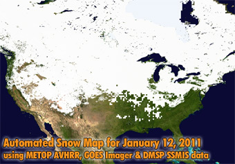
January 12, 2011:
Above: Snow Extent from STAR Automated Snow Map, 1-12-2011
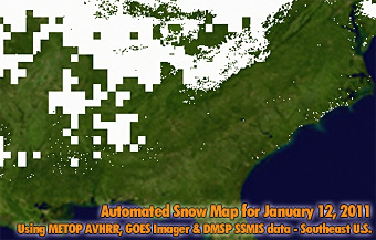
Below: Southeast U.S. Enlargement
STAR Measures Unusually Widespread Snow Cover in the Contiguous U.S.
21 January 2011 - Extensive snowfalls in Eurasia
and in North America brought the snow extent to near-record levels on
both continents early in 2011. On January 12, 2011 the snow extent in
North America reached 18.4 million square km and thus exceeded the
long-term average for the month of January by 1.4 million square km -
an area nearly twice the size of the state of Texas. On that day, at
least some snow cover on the ground was observed in 47 out of 48
contiguous United States.
Dr. Peter Romanov developed and maintains STAR's Automated Snow
Mapping algorithms and website. The automated snow mapping system is
based on a synergy of METOP AVHRR, GOES Imager, MSG SEVIRI and DMSP
SSMIS data and produces daily global snow cover maps. Thanks to Dr.
Romanov of STAR and to the NOAA Environmental Visualization Lab for
providing these images and analysis.
More information:
|
