4 STAR Scientists Honored with 2012 NOAA Bronze Medals
 2 May
2012 - Last month 4 different STAR scientists
were honored for scientific excellence, government service and
leadership at the NOAA Bronze Medal Awards, held on May 1, 2012 at the
NOAA Auditorium in Silver Spring. At the same ceremony, Dr. Celso S. Barrientos was
also posthumously honored.
Xiangqian "Fred" Wu
 Dr.
Wu was honored for scientific engineering in developing an
international science algorithm to provide climate quality data from
geostationary weather satellites, and then engaging with
scientific peers to secure its adoption by international operational
satellite agencies, including NOAA. His combination of scientific
and leadership efforts enable significantly improved climate and weather
applications from geostationary satellites.
Dr. Wu accomplished this by leading the GSICS (Global Space-
Based Intercalibration System) Research Working Group of international
scientists in developing a novel consensus algorithm now used by
international operational satellite agencies, including NOAA. The
algorithm non-climate quality geostationary satellites are continuously
calibrated to climate-quality hyperspectral infrared sensor data on polar-
orbiting satellites, enabling significantly improved climate and weather
applications from geostationary satellites.
Bob Kuligowski
 Dr. Kuligowski was honored for his work advancing satellite-based real-
time precipitation products to improve global hydrologic monitoring and
forecasting. The goal was to implement systems and procedures that provide
reliable, real-time precipitation estimates from NOAA satellite data in
order to improve flash flood monitoring and forecasting around the world,
enabling people in developing nations that are not always well-supported
with meteorological information services to prepare for and respond to extreme weather events,
saving lives and sparing property in the most extreme cases.
In most developing countries, rainfall information is scarce or
unavailable; even where there is radar coverage, forecasts and data may be
incomplete and data outages occur. There is a significant need for
satellite information to improve operational precipitation monitoring and
forecasting. Dr. Kuligowski recognized that the satellite retrieval
processing systems developed at NOAA for domestic use were a valuable tool
to provide the information needed in data-scarce regions worldwide. He led
the enhancement, transfer and implementation of NOAA's Hydro-Estimator
system to recipients in Costa Rica and Mexico. The system in Costa Rica
feeds a flash flood modeling system that provides critical flash flood
guidance to the Meteorological Services of seven Central American
countries. Bob has also led the efforts to include the hydro-estimator in
other regional systems around the globe. Dr. Kuligowski is now working
with the WMO, the Hydrologic Research Center, and USAID to build a Global
Flash Flood Guidance System, and is partnering with the Egyptian
Government to implement a satellite rainfall estimation processing system.
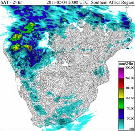
The product implemented by Dr. Kuligowski has made a significant
impact during several intense rainfall events around the globe,
including an unusual rainstorm in Namibia that caused extensive
flooding, and flash flooding in Thailand that affected 286,000 people in
Spring 2011. The Hydro-estimator was the only forecast information resource for
the Haiti-Dominican Republic Flash Flood Guidance System. Hourly rainfall
estimates were also very valuable during the passage of Hurricane Tomas near
the western coast of Haiti in November 2010 and were used for humanitarian
and disaster relief planning.
Mark DeMaria
John A. Knaff
John Kaplan (OAR)
Mark DeMaria's team was recognized for providing skillful operational
hurricane intensity models as demonstrated by the National Hurricane
Center (NHC) forecast verifications for the 2009 and 2010 seasons. The
team developed innovative methods to provide skillful operational
forecasts of intensity changes in tropical cyclones. The success of these
models is a significant first step in solving the problem of forecasting
hurricane intensity change, a problem that has seen little progress
in recent years.
Accurately forecasting hurricane intensity changes can reduce
loss of life and property destruction due to hurricanes. The use of
atmospheric models, which has worked well in other areas such as winter
storms and hurricane tracks, has not worked as well to predict hurricane
intensity changes. DeMaria's team developed an alternate approach to the
problem that takes advantage of the improved prediction of hurricane
tracks and the surrounding environment, as well as remote sensing
observations. However, rather than predicting the intensity changes
directly from the atmospheric models, intensity changes are estimated from
observed relationships between intensity changes and the remote sensing
observations and the more reliable information from the atmospheric
models.
 More accurate and timely storm warnings benefit everyone in hurricane
prone areas. This research provides the NHC with a tool to improve their
forecasts of rapid changes of storm intensity and, consequently, the
storm's destructive potential. For example, during Hurricane Adrian, the
first storm of the 2011 east Pacific season, the statistical models showed
a very high probability of rapid intensification, which was used by NHC to
correctly increase their intensity forecast for that storm, as documented
in their tropical weather discussion products.
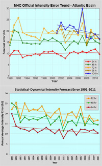
The top panel shows the trends of the Official NHC intensity errors as a
function of year since 1990, which shows slow and steady improvements,
especially at the longer lead times. The bottom panel shows the
performance of the best statistical-dynamical model (SHIPS 1990-2000, D-
SHIPS 2001-2005, LGEM 2006-2011), which shows a rather steady and
impressive reduction of errors over the same 1990-2011 period.
Dr. Celso S. Barrientos
NOAA Distinguished Career Award
Dr. Barrientos was posthumously honored with a NOAA Distinguished Career Award for his long career at NOAA
and the sustained excellence of his work in scientific
management, equal employment, and community outreach efforts
over 41 years of service. His wife accepted the award in his honor. Dr.
Barrientos died in November 2010.

