CIRA VIIRS Team Captures Lightning
 30 May 2012 - Catatumbo lightning is one of the world's most
frequent lightning displays, with thunderstorms forming over the
Catatumbo River in Venezuela an average of 160 nights per year. The
lightning displays last up to 9 hours, beginning shortly after dusk. The
lightning is nearly continuous and so vivid and reliable that it has
been called the "Lighthouse of Maracaibo" and was used by fisherman and
sailors as a navigation aid. Last month, when the moon was about 80%
full, Suomi NPP passed over Lake Maracaibo at night and, sure enough, a
thunderstorm was present right over the mouth of the Catatumbo River.
Curtis Seaman with the CIRA NPP VIIRS team captured this remarkable
image and explained the phenomenon behind it on the CIRA NPP blog.
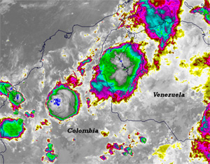
This image, taken from the high resolution imagery IR-window channel
(I-05, 11.45 µm) on 10 May 2012, shows the deep convection over
Venezuela and Colombia. The largest thunderstorm near the center of the
image formed along the shore of Lake Maracaibo, near the mouth of the
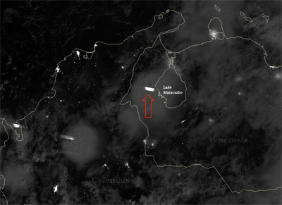
Catatumbo River. Here's what the Day-Night Band saw at the same
time:

VIIRS Day/Night Band image of thunderstorms near Lake Maracaibo (click to enlarge)
The bright, almost rectangular streaks in the image are lightning
strikes. The red arrow points out a lightning strike from the Catatumbo
storm - a "Catatumbo lightning" strike, if you will.
The blocky appearance of lightning is due to the fact that VIIRS is a
scanning radiometer. As the instrument scans the swath of the Earth that
it sees, a bright, transient flash (such as from lightning) will show up
in the along-scan direction as an individual streak of light in each
sensor. The DNB has 16 different sensors that scan the swath
simultaneously, and since lightning typically stretches over a large
enough area to be detected by all of them, you get 16 different streaks
all lined up next to each other. By the time the sensors have rotated
back around for the next scan, the lightning flash has ended, producing
abrupt edges in the direction along the satellite track. Compare this
with the DMSP Operational Linescan System, which produces much more
"streaky" lightning.
In addition to the "Catatumbo lightning", you can see several other
lightning flashes in the two deepest thunderstorms over Colombia. These
are far enough away from Lake Maracaibo that they probably don't count
as Catatumbo lightning.
Other interesting features can be seen in these images as well. The moon
was bright enough to cast shadows in the DNB image, allowing for the
detection of the overshooting tops. These match-up with the coldest
brightness temperatures in the I-05 image (which show up as dark blue to
pure white in this color scale). A few pixels in the largest storm over
Colombia (the one with two visible lightning flashes) have managed to
make it to pure white on the color scale, indicating temperatures below
190 K (-83°C). The dark blue pixels indicate brightness temperatures
between 196 and 190 K (-77 to -83°C). Brrr.
Overshooting tops exist when the convection is so vigorous, it peaks out
above the anvil of the storm and penetrates the stable layer above
(which is usually the stratosphere in storms this deep). In addition to
acting as an indicator for severe weather, overshooting tops are
important for energy and chemical transport between the troposphere and
stratosphere.
It's also interesting to see what looks like thin cirrus over the
Caribbean Sea near Panama (left center of the image) that show up in the
infrared (I-05) image, but not in the DNB. Plus, a number of cold clouds
over Venezuela would appear to be optically thick due to their low
brightness temperatures in the infrared image (yellow starts at 245 K
down to green at 214 K), but they are optically thin enough to see city
lights below in the DNB image.
Special thanks to Curtis Seaman and Don Hillger for bringing
these spectacular images to our attention.
Learn more!

