Innovative Lightning Modeling
Used to Track Storm Intensities
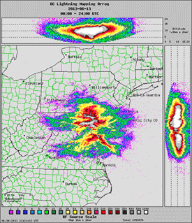
22 June 2013 - Frequent lightning flashes act as
markers for intensifying updrafts and resulting severe weather, as seen
in this composite
video of the June 13, 2013 near-derecho that spawned tornadoes
in the Washington-Baltimore region. STAR researcher Scott Rudlosky and
Patrick Meyers of the University of
Maryland created this animation by combining special once- per-minute
images from the NOAA GOES-14 satellite with data from a regional network
of ground-based lightning sensors (DCLMA). Red arrows show tornadoes
embedded in two areas of intense lightning. Imagery like this will be
routinely available when the next generation of GOES satellites comes
online in 2016 or 2017.
DCLMA observations coupled with recent GOES-14 super-rapid scan
observations provide a depiction of life in the GOES-R era (2016 and
beyond). This video demonstrates the type of imagery that will be
available using observations from the planned GOES-R Geostationary
Lightning Mapper (GLM) and Advanced Baseline Imager (ABI).
To learn more:
|


