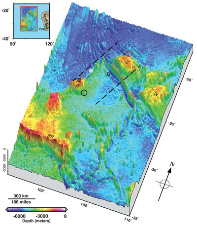
LSA Scientists Produce New View of the MH370 Search Area Click image to enlargeSeafloor topography in the Malaysia Airlines flight MH370 search area. Dashed lines approximate the search zone for sonar pings emitted by the flight data recorder and cockpit voice recorder popularly called black boxes. The first sonar contact (black circle) was reportedly made by a Chinese vessel on the east flank of Batavia Plateau (B), where the shallowest point in the area (S) is at an estimated depth of 1637 meters. The next reported sonar contact (red circle) was made by an Australian vessel on the north flank of Zenith Plateau (Z). The deepest point in the area (D) lies in the Wallaby-Zenith Fracture Zone at an estimated depth of 7883 meters. The Wallaby Plateau (W) lies to the east of the Zenith Plateau. The shallowest point in the entire area shown here is on Broken Ridge (BR). Deep Sea Drilling Project (DSDP) site 256 is marked by a gray dot. The inset in the top left shows the area's location to the west of Australia. Seafloor depths are from the General Bathymetric Chart of the Oceans [2010]27 May 2014 - May 27th's cover article in Eos, Transactions, American Geophysical Union was written by Walter Smith and Karen Marks of STAR's Laboratory for Satellite Altimetry. They produced an updated illustration of the ocean floor in the area where authorities are searching for Malaysia Airlines Flight MH370, missing since March 8. The illustration (at right) combines the existing bathymetric maps of the Indian Ocean floor west of Australia with the locations of reported ping detections, projected flight paths, and details regarding the mountainous and complex nature of the region's topography. Ocean floor maps are constructed by combining observations from direct single- or multi-beam echo sounders with data from satellite altimetry. Smith pointed out that the search for the missing plane is made more difficult because so little is understood about the seafloor in this part of the Indian Ocean. In the southeast Indian Ocean, only 5 percent of the ocean bottom has been measured by ships with echo soundings. Knowledge of the rest of the area comes from satellite altimetry, which provides relatively low-resolution mapping compared to ship-borne methods. "It is a very complex part of the world that is very poorly known," Smith said. A lack of good data about Earth's seafloors not only hinders search efforts, it also makes it harder for scientists to accurately model the world's environment and climate, Smith noted. Today, our knowledge of our planet's undersea topography is "vastly poorer than our knowledge of the topographies of Earth's Moon, Mars and Venus," Smith and Marks write in Eos. This is because these other planetary bodies have no oceans, making their surfaces relatively easy to sense from space. Still, by synthesizing locations related to the MH370 search with the best available ocean topography, this map enhances our understanding of the scale and complexity of the search area and provides valuable information that could be used to guide future search activities. New Bathymetric Survey of the MH370 Search Area Already UnderwayAccording to the Australian Transportation Safety Board, a new bathymetric survey of the MH370 search area is underway as of this week. On May 26, Australian Transportation Safety Board (ATSB) officials said that an area in the southern Indian Ocean the size of Tasmania would now be subject to a full survey using multibeam echo sounders (MBES). A Chinese navy vessel, Zhu Kezhen, has already started on the project. It will be joined by a commercial ship in June, with the work likely to take three months. Additionally, the Australian Joint Agency Coordination Centre (JACC), which disseminates all information on the hunt for MH370, confirmed to the BBC that the MBES survey data would be publicly available. "The bathymetry data gathered in the course of the search for MH370 will become the property of the Australian Government. Recognising the importance of that data, it will be made available to the public via both Australian and international databases," the JACC told the BBC. This development encourages Smith and Marks, who said in the article that they hoped "the data collected during the search for MH370 will be contributed to public data banks and will be a start of greater efforts to map Earth's ocean floor." ReferencesLinks
The article was highlighted in coverage from other news outlets, including:
|
|