- STAR Home
- > News &
Events
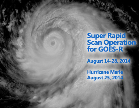
- > 25 August 2014 - STAR Researchers Explore Unique Data and Imagery from Super Rapid Scan Operation for GOES-R
STAR Researchers Explore Unique Data and Imagery
from Super Rapid Scan Operation for GOES-R

25 August 2014 -
STAR researchers, along with their cooperative institutes and others
in NOAA NESDIS, are playing critical roles in the data collection,
dissemination and analysis of unique GOES-14 super rapid scan data.
Using the current back-up geostationary satellite, imagery captured every 1
minute is offering a glimpse into what can be routinely possible with
the next generation geostationary imager. The Advanced Baseline Imager
(ABI) will be able to take images every minute over 2 different areas
approximately 1000 km x 1000 km. The support provided by STAR includes
selecting daily coverage sectors, providing that data to the National
Weather Service (Weather Forecast Offices and several National Centers),
and generating cases of interest for further study. National Centers
involved include the Storm Prediction Center, the Aviation Weather
Center, and the Weather Prediction Center. Normally, with current GOES,
data are collected only every 15 minutes. The very high time resolution allows
small-scale, rapidly-changing cloud features to be observed, analyzed and
studied.
Why is SRSOR data so valuable?
"The very high time resolution allows small-scale, rapidly-changing
cloud features to be observed, tracked, and studied."
- Dan
Lindsey, CoRP / RAMMB
"These unique GOES-14 rapid scan datasets will be used for years to better prepare for the ABI on GOES-R."
- Tim Schmit, CoRP / ASPB
Previously, data
from this special sector were collected during part of 2012, 2013 and
May of 2014. A wide range of phenomena were collected, including
convection, hurricanes (including Hurricane Sandy), fires, fog, etc.
GOES-14 is operated by NOAA NESDIS OSPO. Details, including animations, daily image center points and
related links can be found at: http://cimss.ssec.wisc.edu/goes/srsor2014/GOES-14_SRSOR.html.
The recent data collection period ran from August 14 - 28.
SRSOR Animations:
More information and satellite imagery:
Contributors
Credit and thanks for this work go to: Dan Lindsey and Deb Molenar, CoRP / RAMMB,
and Tim Schmit of CoRP / ASPB.

