Update and Make Operational SMOPS with Observations from GCOM-W/AMSR2 and Near-real-time SMOS
Principal Investigator: Xiwu Zhan

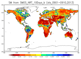
NRT SMOS soil moisture retrieved from SMOPS NRT SMOS TB data

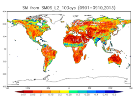
ESA SMOS Level 2 soil moisture product
NRT SMOS soil moisture
products are comparable with the ESA SMOS Level 2 soil moisture product.
SMOPS NRT SMOS soil moisture data has a latency less than 6 hours while
the official ESA SMOS soil moisture products are mostly 12 hours
late.
The Soil Moisture Operational Products System (SMOPS) is NESDIS'
operational global system for providing reliable soil moisture data to
the experimental and operational numerical weather prediction models of
the National Weather Service (NWS) National Centers for Environmental
Prediction (NCEP). SMOPS currently uses data from the Advanced
Scatterometer (ASCAT) on MetOp-A and B of the European Organisation for
the Exploitation of Meteorological Satellite Data (EUMETSAT), Soil
Moisture Ocean Salinity (SMOS) of the European Space Agency (ESA), and
WindSat of the Department of Defense (DoD) Naval Research Laboratory
(NRL). The SMOS soil moisture data feed has roughly 12-hour latency, but
SMOS Level-1 brightness temperature data latency is less than 3 hours.
Since 12-hour latency is too long for use in operational numerical
weather models, one of the FY15 tasks of the SMOPS project was to use
the SMOPS retrieval algorithm to retrieve soil moisture with latency
significantly shorter (about 5 hours) than the official SMOS soil
moisture product latency.
To obtain an observation of brightness temperature, ESA uses a
complicated antenna model with heavy computational costs, which is the
main reason why the SMOS official soil moisture product latency is so
long. To speed up the retrieval process, we developed a quadratic
regression equation to fit the distribution of the brightness
temperature as a function of incidence angle in order to obtain fixed-
angle near real time (NRT) TBs. This simplified approach produced NRT TB
fields similar to ESA SMOS official SMOS L2 TB products in a fraction of
the time.
To retrieve soil moisture, surface temperature (Ts) is also required
in addition to the optical depth (Τ) of the vegetation cover. SMOPS
ingests Ts data from the NCEP Global Forecast System (GFS) and
interpolates them to each grid for the time when the TB data are
acquired from SMOS. The value of Τ is estimated from Enhanced Vegetation
Index (ESI) which is in turn obtained from the Suomi National Polar-
orbiting Partnership (S-NPP) Visible Infrared Imaging Radiometer Suite
(VIIRS). Using the Single Channel Algorithm (SCA), SMOPS could retrieve
soil moisture for an orbit file within two hours after it arrives. The
final SMOS soil moisture products obtained from our NRT TB data are also
similar to the ESA SMOS official Level 2 soil moisture data products
with significantly shorter latency (figures at right). In addition, SMOPS has
been updated with data from the Japanese Aerospace Exploration Agency
(JAXA)'s Global Change Observation Mission (GCOM)-Water 1 (W1) Advanced
Microwave Scanning Radiometer-2 (AMSR2). The Level 2 soil moisture
retrievals in swath files are obtained from NESDIS GAAPS which is
developed by NESDIS GCOM-W1/AMSR2 project team. The additional sensor
improves spatial coverage of the available soil moisture fields,
especially for the 6-hour images.
|

