Demonstration of SNPP VIIRS fire and aerosol product applications
for NWS Applications through "fire & smoke" initiative
Principal Investigator: Shobha Kondragunta

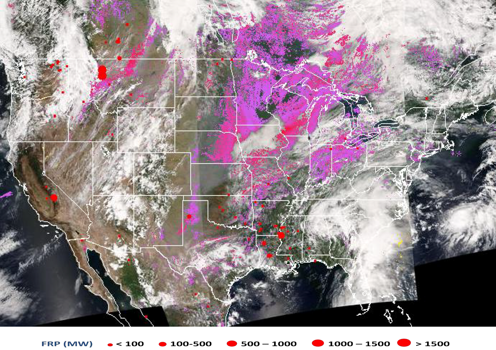
SNPP VIIRS fire hot spots (red dots), smoke mask (pink-magenta)
overlaid on true color image for August 14, 2015. Image generated using
Sensor Data Records (SDRs) from direct broadcast data downloaded at
University of Wisconsin - Madison. The algorithm that generated the
smoke mask is a research algorithm that is being tested on the DB data.
The granules from CONUS and Alaska are processed daily and images
distributed through IDEA
The SNPP VIIRS fire and smoke products are currently distributed to
operational users including air quality forecasters through the IDEA
(Infusing satellite Data into Environmental Applications) website that
includes products generated from Direct Broadcast (DB data). Under the
fire&smoke initiative, the objective is to enhance the IDEA display
system with targeted regions as a focus and interactive zoom capability
to the city level so IMETs (Incident Meteorologists) can use the system
while on ground using their device of choice (e.g., smartphones).
Products to be displayed are fire hot spots, fire radiative power (FRP)
from the new VIIRS operational fire product, proxy burned area computed
from regression models, and areal extent of smoke and dust plumes. This
web-based dissemination system reaches out to many operational users, in
particular air quality forecasters. However, forecasters at weather
forecasting offices (WFOs) often have limited time to access multiple
web-based data and therefore rely on data coming into their AWIPS
monitors. To facilitate the WFOs, the plan is to reformat VIIRS fire and
smoke products available on the IDEA website and make them available for
AWIPS-II applications. As the first phase of this project, STAR aerosol
team gave seminars, interactive tutorials, and live demos to introduce
SNPP VIIRS fire and aerosol products that are available on the IDEA
website.
The summer 2015 has been a very active fire season in the western
region, Alaska, and Canada. Figure 7 shows SNPP VIIRS fire hot spots and
smoke mask overlaid on true color image over CONUS (Contiguous United
States) for August 14, 2015. The smoke mask flag (shown in magenta-pink
color) along with aerosol optical thickness (AOT) product provides the
forecasters with information on not only the amount of aerosol in the
atmosphere but also the type of aerosol. The smoke and dust mask from the
operational product stream generated by the IDPS system is not operational
as its quality is not good. STAR aerosol team developed an alternate
algorithm that runs on the DB data and provides it along with AOT product.
These satellite-derived products are the staple for air quality
forecasters who are well trained on how to use these products in their
daily air quality forecasts. However, the weather forecasters, especially
in the western region, who are increasingly being asked to address the
smoke forecasting needs are not familiar with satellite derived aerosol
products. To address this, a presentation by an air quality forecaster was
given to participants of the fire & smoke initiative on the case study of
June 9, 2015 involving the transport of smoke from fires in Alaska and
Canada and how the smoke led to air quality standard violations for the
eastern US. This presentation along with other informal telecons, was used
to expose the forecasters in the Western Region and Alaska to SNPP VIIRS
aerosol products.
As a result of various meetings including a 1-day satellite air quality
proving ground workshop on September 9, 2015, the VIIRS fire & smoke team
obtained valuable feedback to revise the dissemination of the products.
Although forecasters use products from different satellites, some of them
prefer a blended product. This blended product of fire and smoke aerosols
need to inform them where the hot spots are, where the smoke is now, and
where the smoke is headed. In particular, they are not concerned about
which specific satellite has provided this information. Contrary to this,
air quality forecasters well trained in the use of satellite data prefer
observations from different satellites at different times to capture
diurnal variability in aerosols and changes to cloud cover. To meet these
two diverse requirements, the IDEA website will be modified to have one-
stop information on fires and smoke for different regions (e.g., NWS
Alaska, NWS Western Region, etc.). The blended version of product display
system will also be ported to AWIPS-II.

