27 Jul 2024 - 02:10 UTC
GOES-East Full Disk - Day Cloud Phase / Night Microphysics
2 hour loop - 12 images - 10 minute update
To enlarge, pause animation & click the image. Hover over popups to zoom. Use slider to navigate.


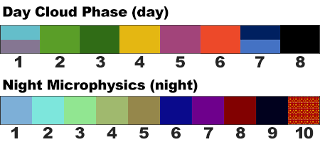
Day Cloud Phase key:
1 - Low level clouds with water droplets (cyan, lavender)
2 - Glaciating clouds (green)
3 - Snow (shades of green)
4 - Thick high level clouds with ice particles (yellow)
5 - Thin mid level clouds with water droplets (magenta)
6 - Thin high-level clouds with ice particles (red-orange)
7 - Land surface (shades of blue)
8 - Water surface (black)
Night Microphysics key:
1 - Fog (dull aqua to gray)
2 - Very low, warm cloud (aqua)
3 - Low, cool, cloud (bright green)
4 - Mid water cloud (light green)
5 - Mid, thick, water/ice cloud (tan)
6 - High, thin, ice cloud (dark blue)
7 - High, very thin, ice cloud (purple)
8 - High, thick cloud (dark red)
9 - High, thin cloud (near black)
10 - High, thick, very cold cloud (red/yellow, noisy)
The STAR GOES Imagery Site team has developed the Day Night Cloud Micro Combo product to more efficiently deliver the observational value of both the Day Cloud Phase Distinction & Night Microphysics RGB products.
Daytime: Day Cloud Phase RGB The daytime period of this RGB helps evaluate the phase of cooling cloud tops to monitor convective initiation, storm growth, and decay. It can also be used to identify snow on the ground. The Day Cloud Phase Distinction RGB takes advantage of cloud reflectance differences between the visible and near infrared channels and temperature variances between land and clouds in the infrared to provide increased contrast between background surfaces and phases of clouds (i.e., water vs. ice). Due to its reliance on visible bands 2 and 5, it is only usable during daylight hours. This composite was developed by the Japan Meteorological Agency (JMA) for Himawari-8. Interpretation is still under investigation.
Nighttime: Nighttime Microphysics RGB The distinction between low clouds and fog in satellite imagery is challenging. While the difference between the 10.4 and 3.9 μm channels has been a regularly applied product to meet aviation forecast needs, the Nighttime Microphysics (NtMicro) RGB adds another channel difference (12.4- 10.4 μm) as a proxy to cloud thickness and repeats the use of the 10.4 μm thermal channel to enhance areas of warm (i.e., low) clouds where fog is more likely. The NtMicro RGB is also an efficient tool to quickly identify other cloud types in the mid and upper atmosphere.
• For more details, see the Day Night Cloud Micro Combo Product Guide, (PDF, 2.87 MB)


