
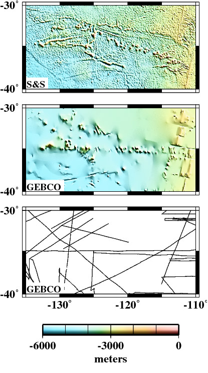
Foundation Seamounts and trough are well resolved in Smith & Sandwell grid. Only features traversed by ship tracks (lines) show up in GEBCO grid. (click image to enlarge)
Altimetric Bathymetry
An evaluation of publicly available global bathymetry grids
We evaluate the strengths and weaknesses of six publicly available global bathymetry grids: DBDB2 (Digital Bathymetric Data Base; an ongoing project of the Naval Research Laboratory), ETOPO2 (Earth Topography; National Geophysical Data Center, 2001, ETOPO2 Global 2' Elevations [CD-ROM]. Boulder, Colorado, USA: U.S. Department of Commerce, National Oceanic and Atmospheric Administration), GEBCO (General Bathymetric Charts of the Oceans; British Oceanographic Data Centre, 2003, Centenary Edition of the GEBCO Digital Atlas [CD-ROM] Published on behalf of the Intergovernmental Oceanographic Commission and the International Hydrographic Organization Liverpool, UK), GINA (Geographic Information Network of Alaska; Lindquist et al., 2004), Smith and Sandwell (1997), and S2004 (Smith, unpublished). The Smith and Sandwell grid, derived from satellite altimetry and ship data combined, provides high resolution mapping of the seafloor, even in remote regions. DBDB2, ETOPO2, GINA, and S2004 merge additional datasets with the Smith and Sandwell grid; but moving from a pixel to grid registration attenuates short wavelengths (<20 km) in the ETOPO2 and DBDB2 solutions.
Short wavelengths in the GINA grid are also attenuated, but the cause is not known. ETOPO2 anomalies are offset to the northeast, due to a misregistration in both latitude and longitude. The GEBCO grid is interpolated from 500 m contours that were digitized from paper charts at 1:10 million scale, so it is artificially smooth; yet new efforts have captured additional information from shallow water contours on navigational charts. The S2004 grid merges the Smith and Sandwell grid with GEBCO over shallow depths and polar regions, and so is intended to capture the best of both products. Our evaluation makes the choice of which bathymetry grid to use a more informed one.
These results are published in:
K. M. Marks and W. H. F. Smith, An Evaluation of Publicly Available Global Bathymetry Grids, Marine Geophys. Researches, Vol. 27, No. 1, 19-34, 2006. DOI: 10.1007/s11001-005-2095-4.