
Altimetric Bathymetry
Detecting Seamounts in Stacked Altimeter Data
Stacked sea surface height (SSH) profiles from repeat ground-track satellite radar altimeters are produced with an algorithm that robustly combines data from repeat cycles to reinforce SSH signal from seafloor topography while reducing measurement noise and SSH attributed to time-varying ocean dynamics. The algorithm has been applied to SSH from the Ka-band altimeter on SARAL/AltiKa and the high-rate SRAL delay-dopper radar altimeter on Sentinel-3A and Sentinel-3B.
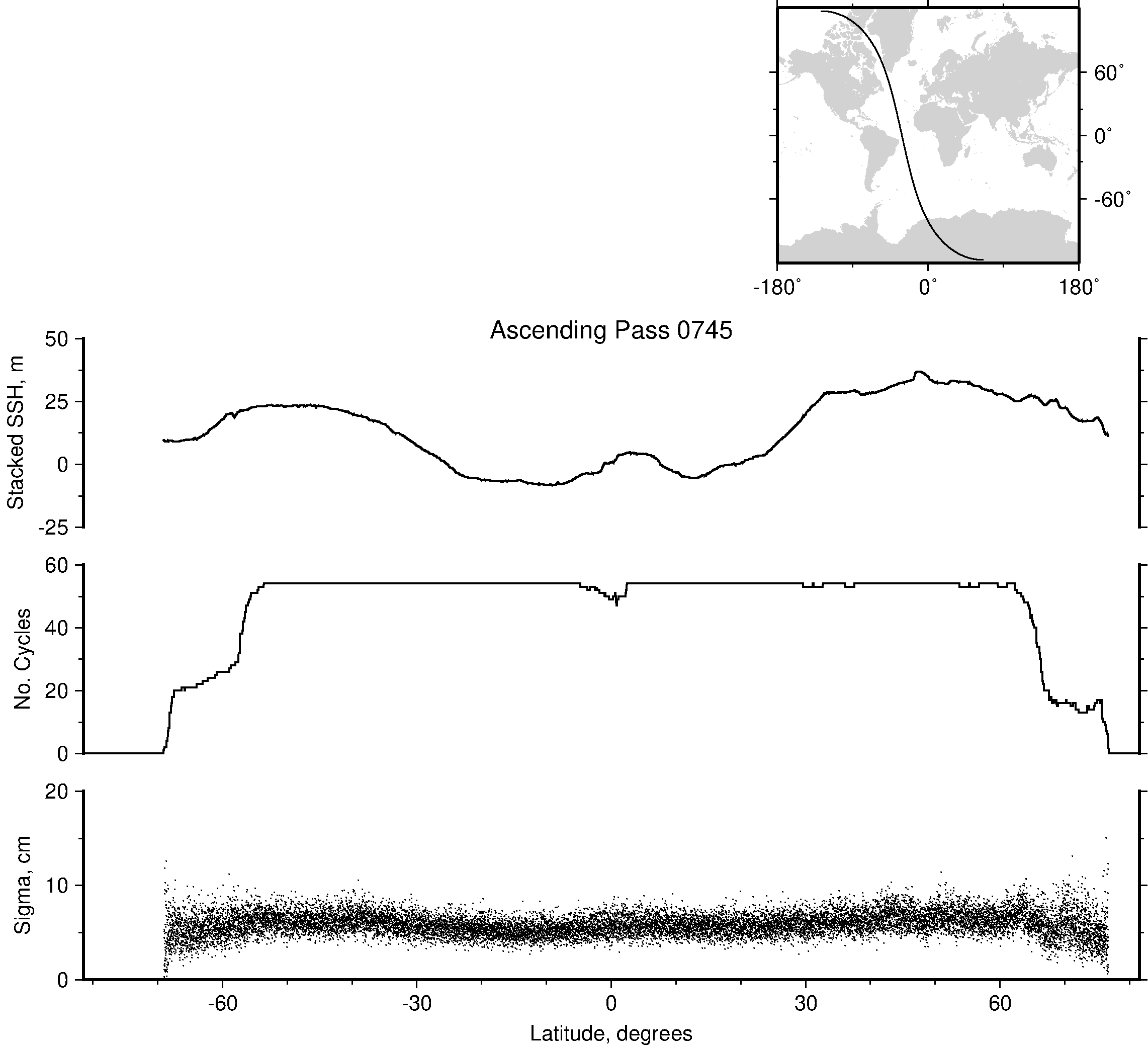
Figure 1. Profiles of stacked sea surface height, number of cycles used in stack, and sigma along Sentinel-3A pass 745.
AltiKa/SARAL is the first altimeter mission to operate with a Ka-band radar. The Sentinel-3 missions are the first satellites to operate globally using a high-rate delay-Doppler radar altimeter instrument. For each Sentinel-3 mission, the stacking algorithm has been applied to SSH from two different methods of processing altimeter echoes, a low-rate (Psuedo-Low Rate Mode or PLRM) constructed to be similar to Jason-3 altimetry and high-rate (SAR Mode or SARM). Comparisons of stacking results from different radar instruments and processing methods will be used to characterize each technology's ability to detect seamounts.
The new datasets contain longitude, latitude, number of revisit cycles useable at each point, error in a single measurement, and median SSH at 1-km intervals along the ground tracks of all satellite passes (1002 passes for AltiKa and 770 passes for Sentinel-3A and Sentinel-3B).
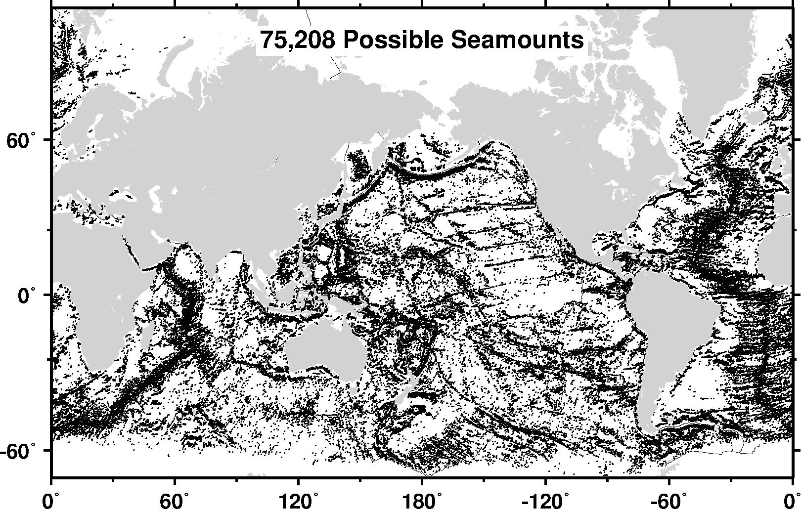
Figure 2. Stacked sea surface height data collected by the AltiKa may reveal more than 75,000 possible small seamounts globally, and resolves seamounts down to 720 m tall.
Acknowledgment: Users are free to use the information hosted on this site in their research, provided credit is given to the NOAA / NESDIS Center for Satellite Applications and Research (STAR) Laboratory for Satellite Altimetry (LSA). Users are also asked to cite the following publication whenever these data are used: Marks, K. M. & Smith, W. H. F. (2018). A Method of Stacking AltiKa Repeat Cycle Data that May Reveal 75,000+ Possible Small Seamounts. Earth and Space Science, 5, 964-969. DOI: 10.1029/2018EA000440
Data access:
- STAR website
- NCEI archive of global stacked sea surface height profiles from AltiKa satellite altimeter data (NCEI Accession 0174134) DOI: 10.25921/8hk9-fk45
- NCEI archive of global stacked sea surface height profiles from Sentinel-3A SARM satellite altimeter data (NCEI Accession 0219900) DOI:10.25921/0rve-s239
- NCEI archive of global stacked sea surface height profiles from Sentinel-3A PLRM satellite altimeter data (NCEI Accession 0219901) DOI:10.25921/m0hw-a781
- NCEI archive of global stacked sea surface height profiles from Sentinel-3B SARM satellite altimeter data (NCEI Accession 0219903) DOI:10.25921/wc1q-m472
- NCEI archive of global stacked sea surface height profiles from Sentinel-3B PLRM satellite altimeter data (NCEI Accession 0219902) DOI:10.25921/88xm-2k19
Point of Contact: Karen.Marks@noaa.gov
End Users
Data from these stacked products may be used to resolve previously unknown small seamounts, augment seamount census studies, and potentially identify areas that may have new habitats or pose hazards to submarine navigation.