Altimetric Bathymetry
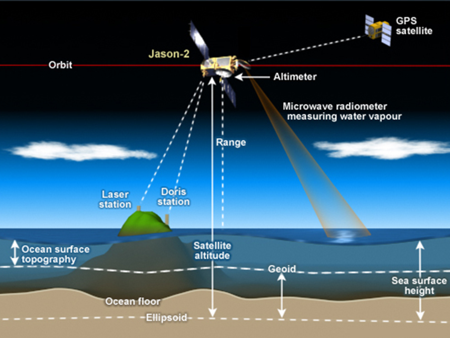
An altimeter measures how high something is. Satellite radar altimeters measure the ocean surface height (sea level) by measuring the time it takes a radar pulse to make a round-trip from the satellite to the sea surface and back. Bathymetry is measurement of the depth of the ocean. Our group does research to see how we can estimate bathymetry from space radar measurements of sea level.
Mars, Venus and Earth's Moon are better mapped than Earth. These other planetary bodies have dry surfaces, making their surface topography accessible to laser or radar measurements of their elevation. Seventy percent of Earth's surface topography is under the oceans, and cannot be directly sensed by lasers or radars. Direct measurement of ocean depths is done by echo sounders carried by ships, but only a few percent of the ocean has been mapped this way. Ship survey lines cover the remote oceans about as sparsely as the Interstate Highway System covers the United States, and gaps between surveys can be as large as 105 km2, or about the size of the state of New Jersey.
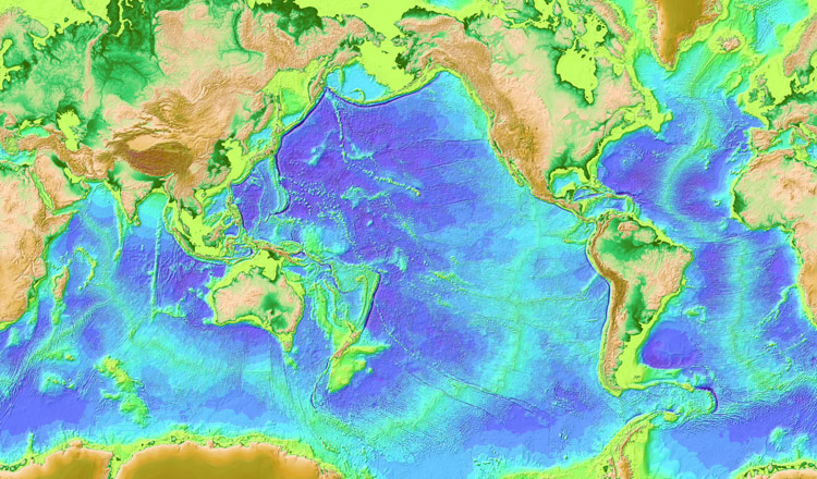
We use satellite radar altimeter measurements of the ocean surface height (sea level) to infer the presence of mountains below. Mountains on the sea floor add extra pull to Earth's gravity field, drawing more water around them and bulging the sea surface outward. This way of estimating depth we call "altimetric bathymetry".
An undersea mountain has to be about a mile high and several miles wide in order to generate enough of a bump in sea level to be recognizable in current radar altimeter data. Therefore altimetric bathymetry is not as accurate or detailed as echo sounding from ships. Even so, because altimeter satellites cover the whole Earth while ships have mapped only a few percent, the best global bathymetric models combine conventional echo soundings with altimetric bathymetry. Our research led to a bathymetric model that has been widely used in the scientific community for more than a decade, and was recently incorporated into GEBCO products and the popular web application Google Earth.
Improving this technique requires research in several areas, including more precise radar measurements (now coming from "delay-Doppler" or "SAR" altimeters) and improved understanding and calibration of the relationship between radar altimeter sea level and ocean bathymetry. These are research topics in our group.
How gravity and sea level interact
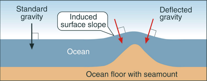
The gravitational pull of a mountain adds to Earth's overall gravity, and this introduces small tilts in the direction that gravity pulls. By this mechanism, undersea mountains tilt sea level. We can use satellite radar measurements of sea level to detect these tilts and infer the presence of uncharted mountains below the sea surface.
This cartoon exaggerates the effect for clarity. In reality, though an undersea mountain can be a few kilometers high, the bump in sea level it produces is only a few meters high. A typical seamount tilts the sea surface by a very small angle, around 30 micro-radians. We are trying to measure these tilts to 1 micro-radian to discover the unknown topography of the sea floor. One microradian of sea surface slope means that sea level changes by 1 mm vertically for each 1 km you move horizontally. That is about 1/16th inch in one mile.


