Day One - Tuesday
| Time |
Presentations / Topics |
Speaker |
Affiliation |
| 0915 - 0930 |
OSO Introduction, (PDF, 1.53 MB) |
Francois Montagner |
EUMETSAT |
| 0930 - 0945 |
A Perspective on Current Status, (PDF, 1.72 MB) |
Ralph Rayner |
NOAA IOOS and London School of Economics |
| 0945 - 1010 |
Present status and evolution perspectives from CMEMS: a state-of-the-art-contribution to operational oceanography, (PDF, 5.33 MB) |
Antonio Repucci |
Mercator Ocean International |
| 1030 - 1345 |
Theme 1: Redefining the Operational Paradigm |
blank cell heading row |
blank cell heading row |
| 1030 - 1100 |
Redefining the Operational Paradigm, (PDF, 8.56 MB) |
Veronica Lance |
NOAA/NESDIS/STAR/SOCD and NOAA CoastWatch/OceanWatch/PolarWatch Program |
| 1100 - 1115 |
Operational EUMETSAT Satellite Products and Servies for Oceanography: Status and Outlook, (PDF, 3.93 MB) |
Estelle Obligis |
EUMETSAT |
| 1115 - 1130 |
Ocean and Coastal Remote Sensing in the NOAA Center for Satellite Applications and Research (STAR): Product Development and Transitions between Research and Operations, (PDF, 10.73 MB) |
Paul DiGiacomo |
NOAA/NESDIS/STAR |
| 1300 - 1315 |
Application of Satellite Oceanography to Weather, Water, and Climate Services, (PDF, 3.89 MB) |
Thomas Cuff |
NOAA/NWS |
| 1315 - 1330 |
Operational exploitation of sea-surface temperature data retrieved from satellites, (PDF, 2.11 MB) |
Anne O'Carroll |
EUMETSAT |
| 1330 - 1345 |
Issues around sustaining operational SST analyses in a rapidly changing satellite constellation, (PDF, 2.47 MB) |
Helen Beggs |
Bureau of Meterology, Melbourne, Australia |
7-17-2019 5:43 pm
Day Two - Wednesday
| Time |
Presentations / Topics |
Speaker |
Affiliation |
| 0900 - 1115 |
Theme 2: Linking Providers and Users |
blank cell heading row |
blank cell heading row |
| 0900 - 0930 |
Connecting Data Providers and Users - Examples from the West Coast Node of CoastWatch, (PDF, 3.73 MB) |
Cara Wilson |
NOAA CoastWatch |
| 0930 - 0945 |
Long Time Series of Satellite homogeneous Wind and Ocean Heat Flux Analyses, (PDF, 3.74 MB) |
Abderrahim Bentamy |
Ifremer |
| 0945 - 1000 |
Ocean Literacy Campaign in Bangladesh, (PDF, 8.89 MB) |
Mohammad Uddin |
University of Chittagong |
| 1000 - 1015 |
Use if Operational Ocean Satellite Data in Operational Ocean Forecast Systems: Opportunities and Challenges, (PDF, 1.75 MB) |
Avichal Mehra |
NOAA/NWS/EMC |
| 1030 - 1045 |
The Role of Satellite Observations in Understanding the Dynamics of the Mediterranean and Black Seas in the Framework of CMEMS, (PDF, 2.94 MB) |
Rita Lecci |
CMCC Foundation |
| 1045 - 1100 |
Use of SSH and SST data in operational 4DVAR Ocean Data Assimilation Systems in JMA, (PDF, 3.7 MB) |
Yosuke Fujii |
JMA, MRI |
| 1100 - 1115 |
Satellite Oceanographic Data Assimilation in the US West Coast Operational Forecast System (WCOFS), (PDF, 3.33 MB) |
Jiangtao Xu |
NOAA/NOS/CO-OPS |
| 1330 - 1500 |
Theme 3: Helping Users Shop in the Data Supermarket |
blank cell heading row |
blank cell heading row |
| 1330 - 1345 |
Coral Reef Stakeholders' Use of NOAA Coral Reef Watch Ecoforecasts During the 2014-2017 Global Coral Bleaching Event, (PDF, 6.42 MB) |
Mark Eakin |
NOAA Coral Reef Watch |
| 1345 - 1400 |
Utilization of Satellite-Derived Salinity as a Predictor for Indian Monsoon Forecasting, (PDF, 4.29 MB) |
Subrahmanyam Bulusu |
USC, ONR |
| 1400 - 1415 |
Satellite Data Access in the Copernicus Era, (PDF, 1.91 MB) |
Hayley Evers-King |
EUMETSAT |
| 1415 - 1430 |
OceanWatch Central Pacific:Satellite Oceanography Products and Applications, (PDF, 2.57 MB) |
Melanie Abecassis |
University of Hawaii |
| 1430 - 1445 |
Progress Toward Data Discovery, Machine Readability, and Interoperability at NOAA: NOAA OneStop and the NESDIS Cloud, (PDF, 1.98 MB) |
Kenneth Casey |
NOAA NCEI |
| 1445 - 1500 |
The International MOSAiC Expedition: Decision making and planning by means of operational satellite and model products, (PDF, 3.98 MB) |
Thomas Krumpen |
Alfred Wegener Institute for Polar and Marine Research |
8-07-2019 12:55 pm
Day Three - Thursday
| Time |
Presentations / Topics |
Speaker |
Affiliation |
| 0845 - 0930 |
Theme 4: Commercial Provider Forum |
blank cell heading row |
blank cell heading row |
| 0845 - 0930 |
Collecte Localisation Satellites, (PDF, 4.31 MB) |
C. Dufau |
CLS |
| 0845 - 0930 |
Applications of Satellite Oceanographic Data in Fishery Industry, (PDF, 2.32 MB) |
Jianke Li |
Maxar |
| 0845 - 0930 |
Specific Product Development for a Target "User Group": Ocean Forecast Fields for Oregon Fishermen, (PDF, 4.58 MB) |
Ted Strub |
Ian Black College of Earth, Ocean, and Atmospheric Sciences |
| 1030 - 1145 |
Theme 5: Governmet to High Level Users and End-to-End Integration |
blank cell heading row |
blank cell heading row |
| 1030 - 1045 |
Marine and Coastal Areas Management in Western Africa: A Case of EO data Application, (PDF, 3.12 MB) |
Bennet Foli |
University of Ghana |
| 1045 - 1100 |
Utilizing Hetergeneous Satellite Products to Understand and Improve Predictability of the Indian Summer Monsoon, its Intra-Seasonal Variability, and its Relation to Large Scale Convective Regimes over the Indian Ocean, (PDF, 1.5 MB) |
Gad Levy |
North West Research Associates, PORSEC |
| 1100 - 1115 |
Blue Planet Oceans and Society: a GEO Initiative, (PDF, 5.31 MB) |
Emily Smail |
University of Maryland, NOAA/NESDIS/STAR |
| 1115 - 1130 |
Assessment of marine and coastal eutrophication using remotely sensed chlorophyll-a concentration, (PDF, 5.99 MB) |
Genki Terauchi |
Northwest Pacific Region Environmental Cooperation Center/NOWPAP CEARAC |
| 1130 - 1145 |
Operational ecosystem and fish population modelling, (PDF, 3.64 MB) |
Patrick Lehodey |
Collecte Localisation Satellites |
| 1500 - 1545 |
7: Plenary Path Forward |
blank cell heading row |
blank cell heading row |
| 1500 - 1545 |
Assessing the Value of Oceanographic Observations, (PDF, 2.12 MB) |
Chris Lauer |
NOAA |
| 1500 - 1545 |
The Path Forward, (PDF, 1.7 MB) |
Craig McLean |
NOAA |
| 1500 - 1545 |
Accelerating Toward NOAA's Next-Generation Earth Observation Architecture, (PDF, 1.74 MB) |
Karen St. Germain |
NOAA |
7-17-2019 12:35 pm
List of Posters and Presenters
| Title |
First author / presenter |
Affiliation |
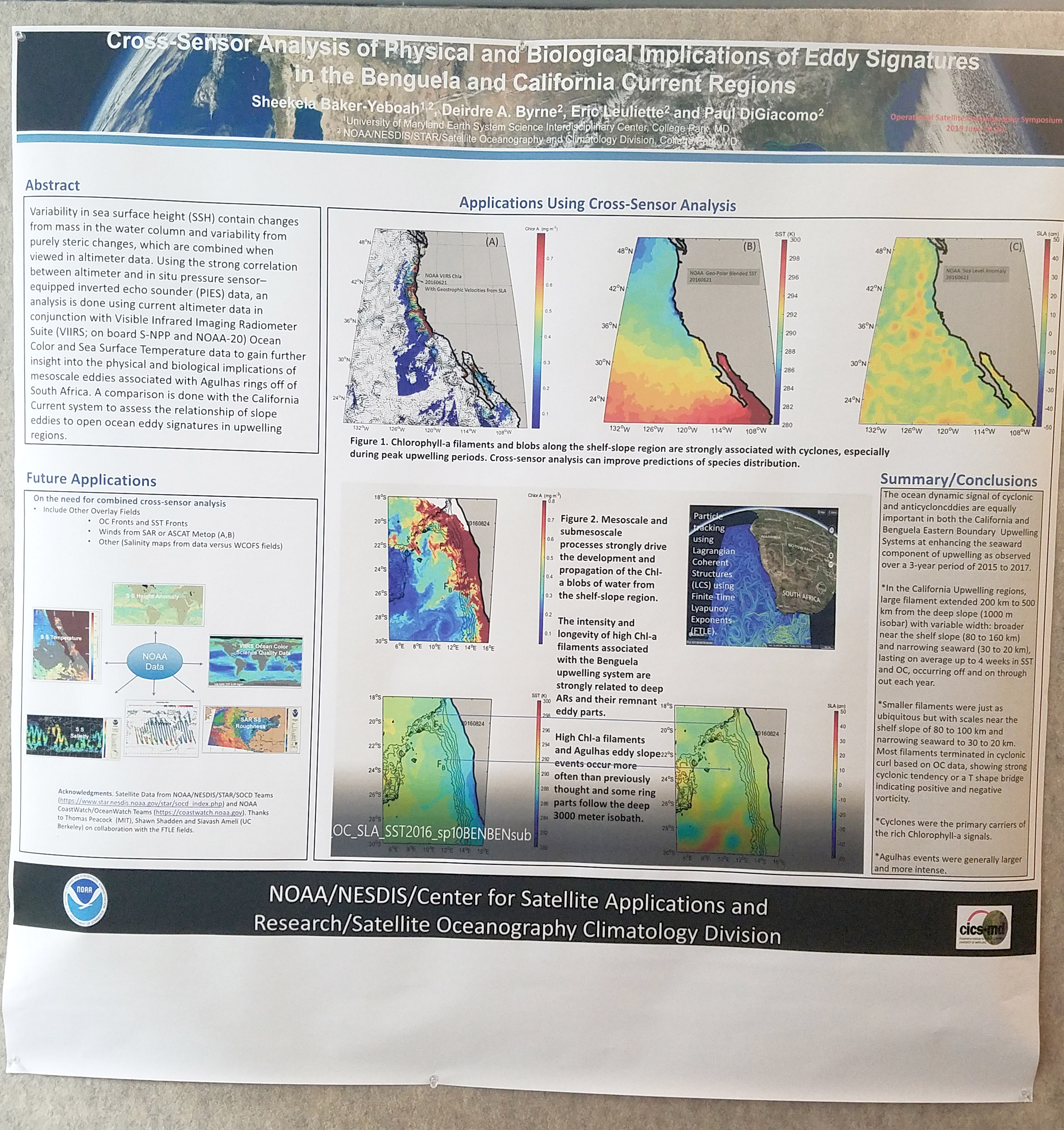
| Cross-Sensor Analysis of Physical and Biological Implications of Eddy Signatures in the Benguela and California Current Regions, (JPG, 2.11 MB) |
Baker-Yeboah, Sheekela |
NOAA / NESDIS / STAR / SOCD |
| OceanWatch -- a multi-pronged approach to disseminating ocean remote sensing data |
Abecassis, Melanie |
University of Hawaii |
| Thought on operational oceanography in West African countries |
Affian, Kouadio |
CURAT |
| SST improvements in the NASA GMAO Weather Analysis and Prediction System |
Akella, Santha |
NASA |
| Issues around Providing Operational SST Analyses for Climate Applications in a Rapidly Changing Satellite Constellation |
Beggs, Helen |
Bureau of Meterology, Melbourne, Australia |
| Long Time Series of Homogeneous Satellite Wind Analyses over Global Oceans |
Bentamy, Abderrahim |
Ifremer |
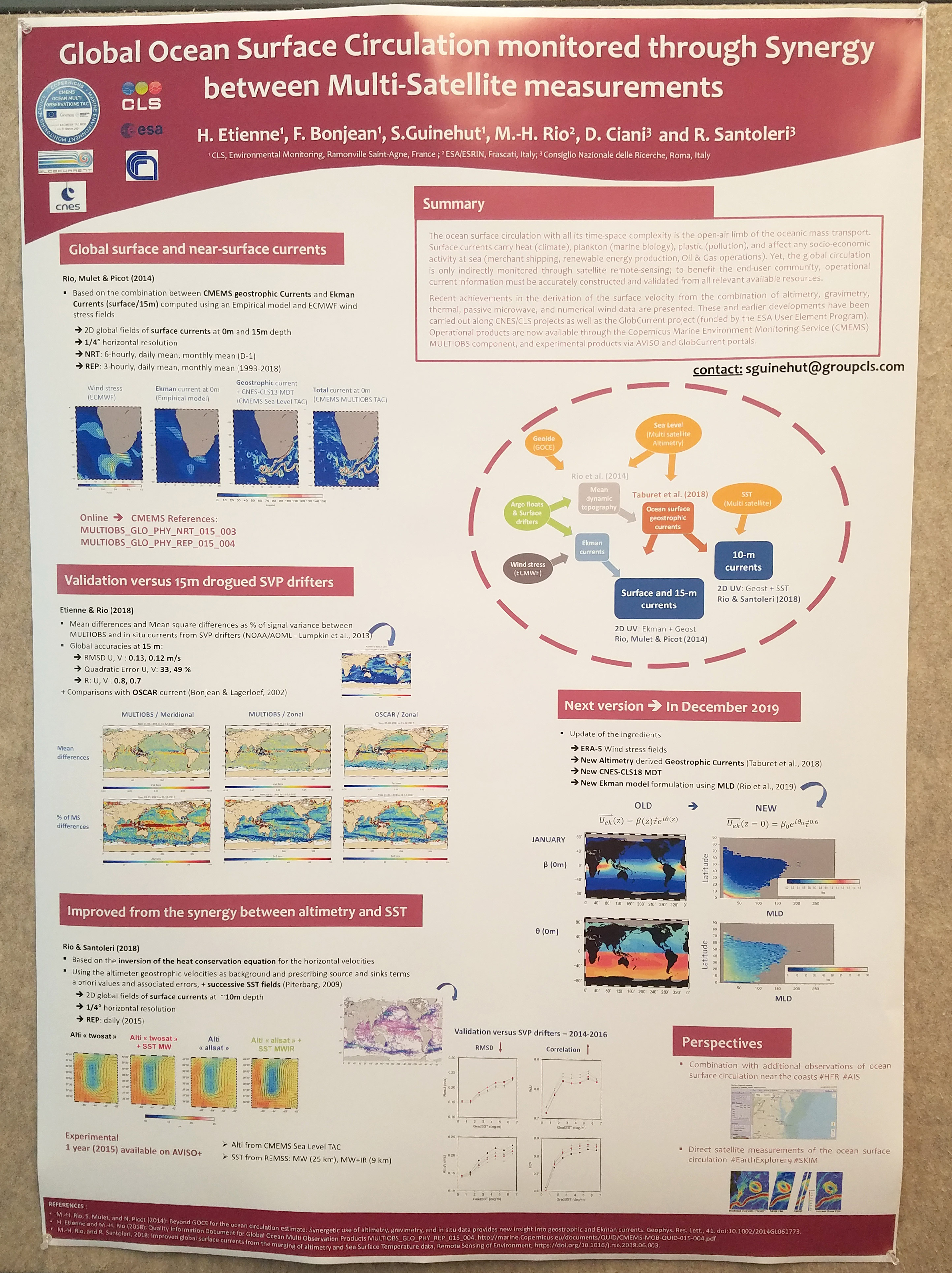
| Global Ocean Surface Circulation Monitored through Synergy between Multi-Satellite Measurements, (JPG, 2.12 MB) |
Bonjean, Fabrice |
Collecte Localisation Satellites |
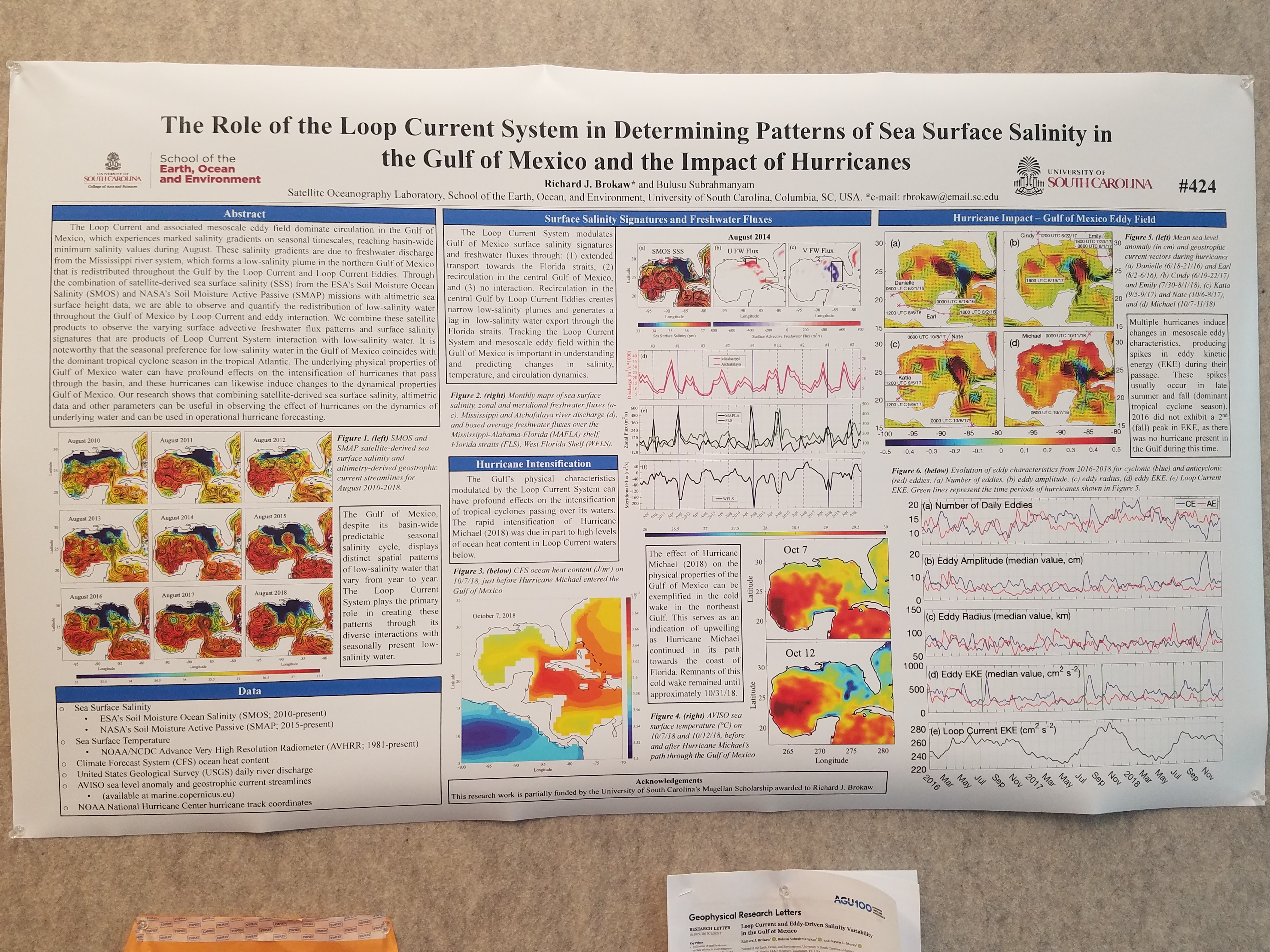
| The Role of the Loop Current System in Determining Patterns of Sea surface Salinity in the Gulf of Mexico and the Impact of Hurricanes, (JPG, 4.47 MB) |
Brokaw, Richard J. |
University of South Carolina |
| Utilization of Satellite-derived Salinity as a Predictor for the Indian Monsoon Forecasting |
Bulusu, Subrahmanyam |
USC, ONR |
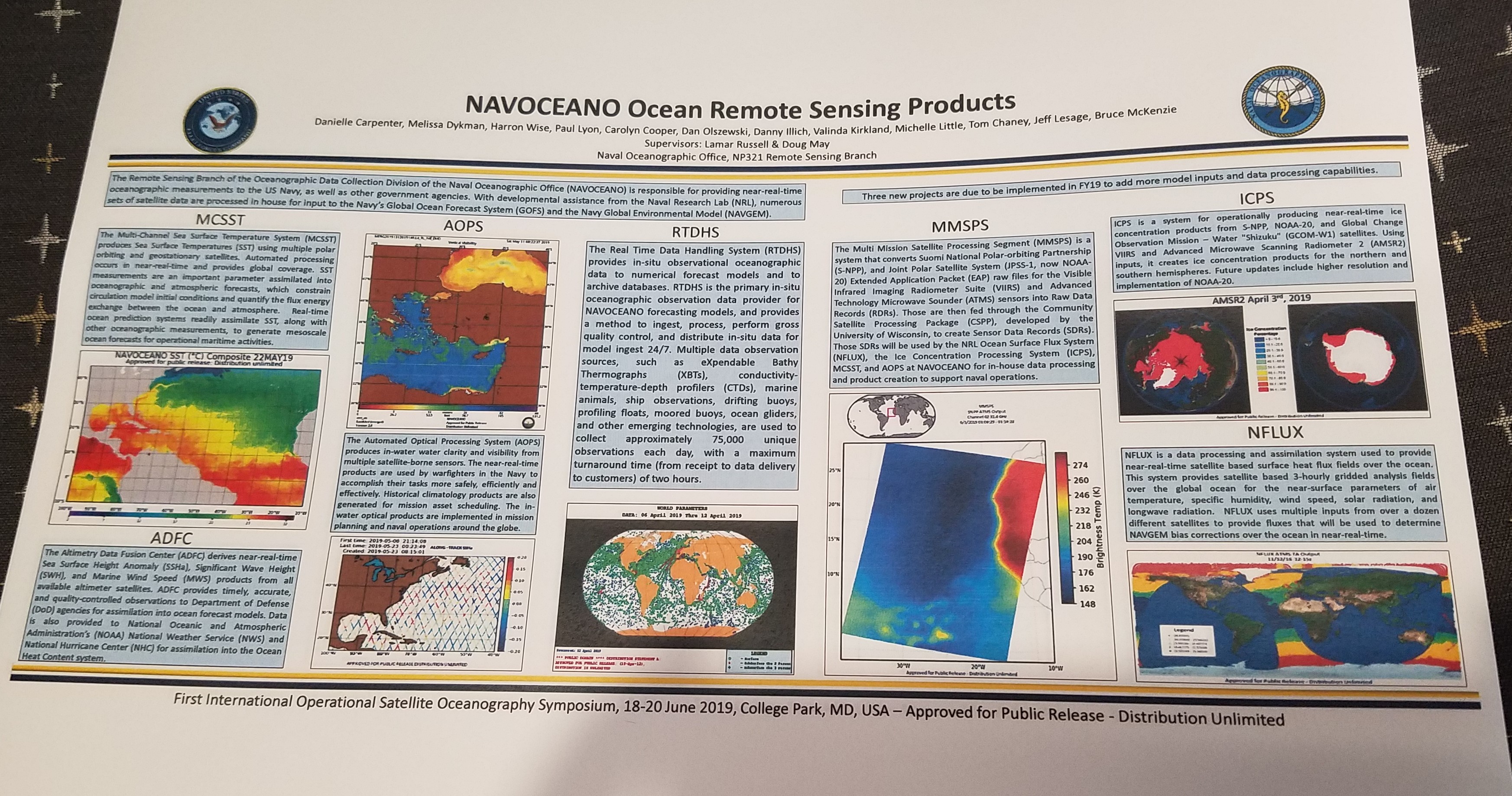
| NAVOCEANO Ocean Remote Sensing Products, (JPG, 1.64 MB) |
Carpenter, Danielle |
NAVO |
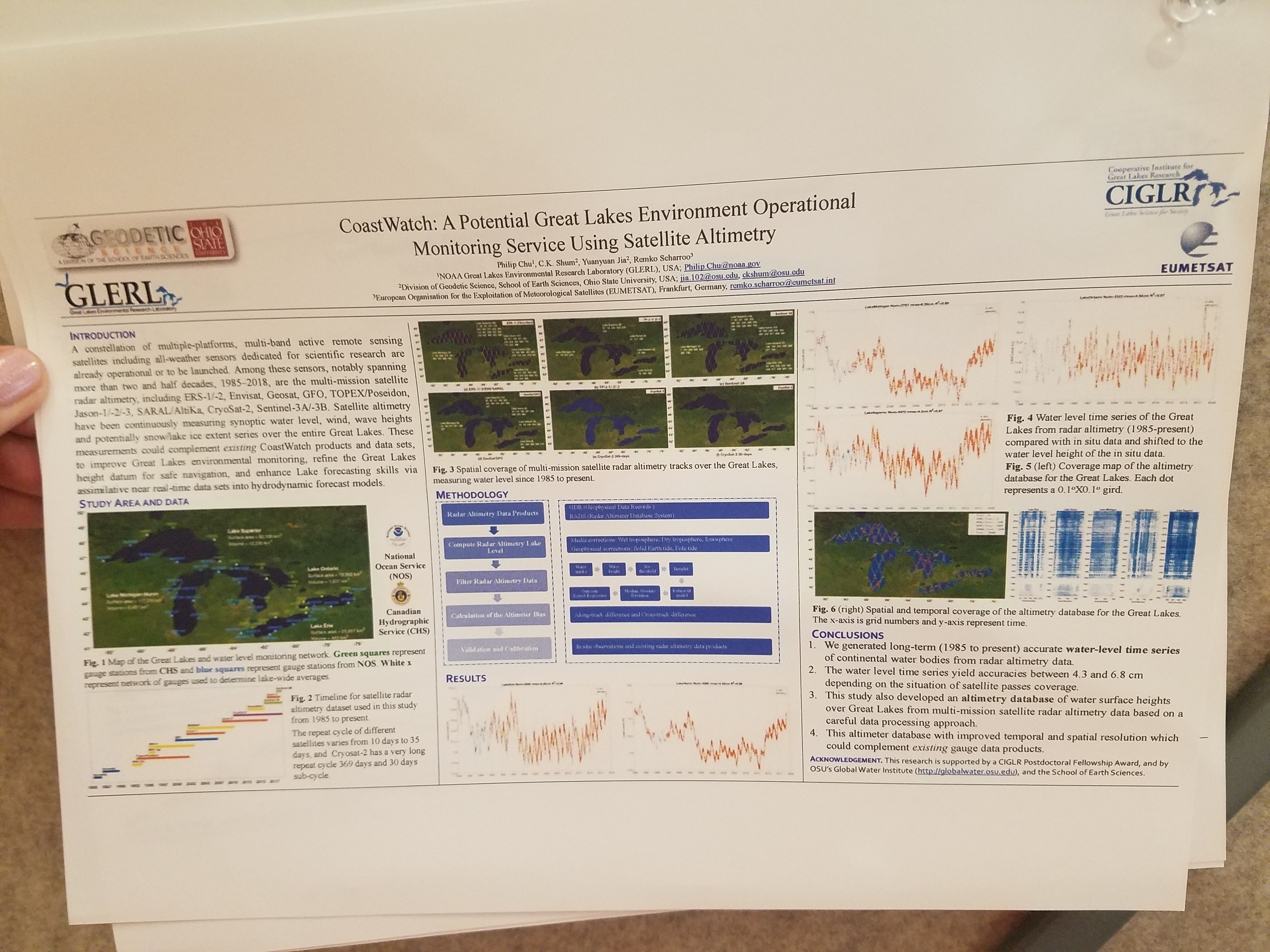
| CoastWatch: A Potential Great Lakes Environment Operational Monitoring Service Using Satellite Altimetry, (JPG, 3.63 MB) |
Chu, Philip |
GLERL |
| A Synergetic Approach for the Space-Based Retrieval of the Sea-Surface Currents in the Mediterranean Sea |
Ciani, Daniele |
CNR-ISMAR |
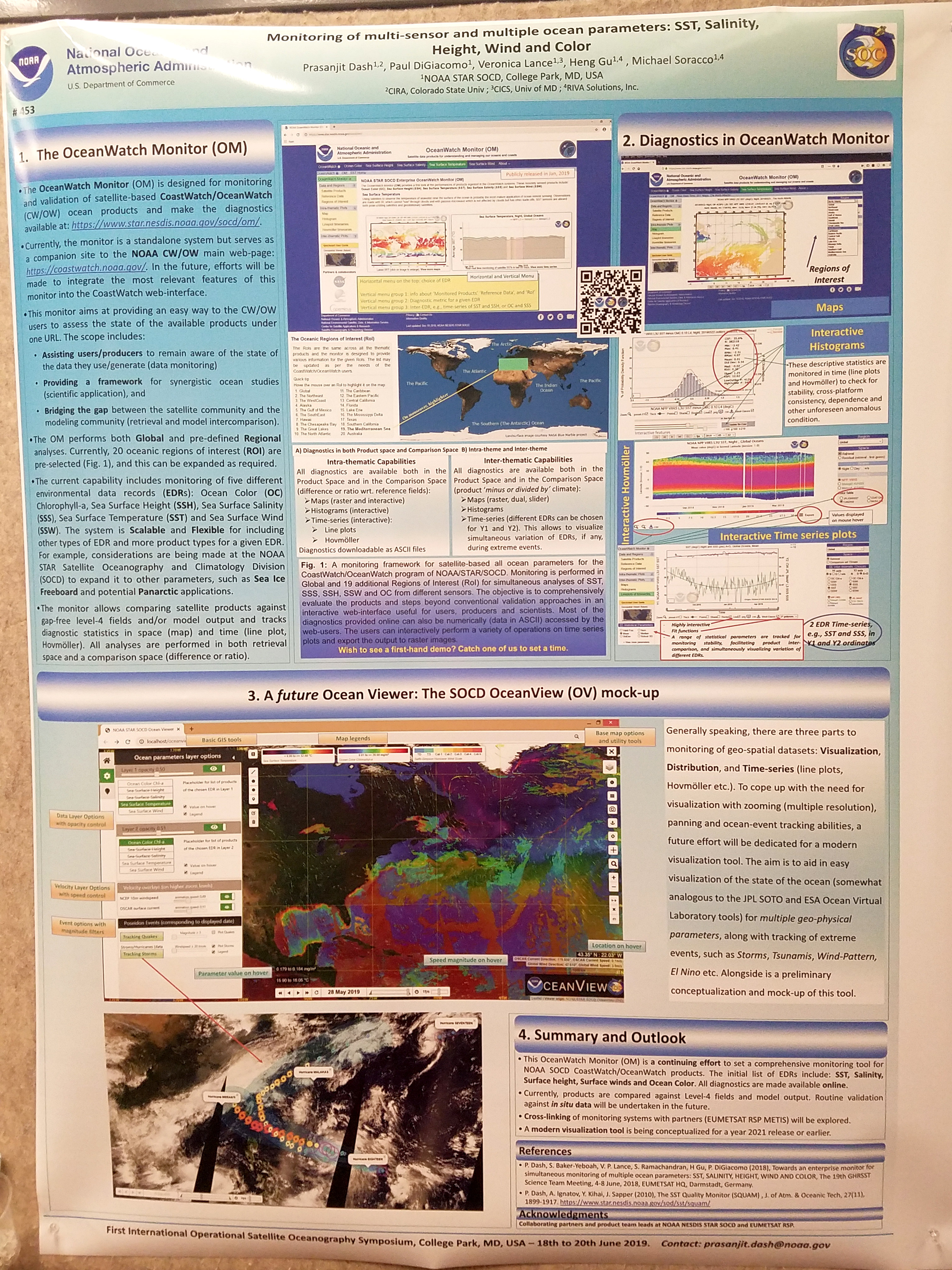
| Monitoring of multi-sensor and multiple ocean parameters: SST, Salinity, Height, Wind, and Color, (JPG, 3.2 MB) |
Dash, Prasanjit |
NOAA / NESDIS / STAR / SOCD |
| Satellite Solutions for Tracking Marine Litter in the Ocean, (JPG, 3.65 MB) |
Dufau, C. |
Collecte Localisation Satellites |
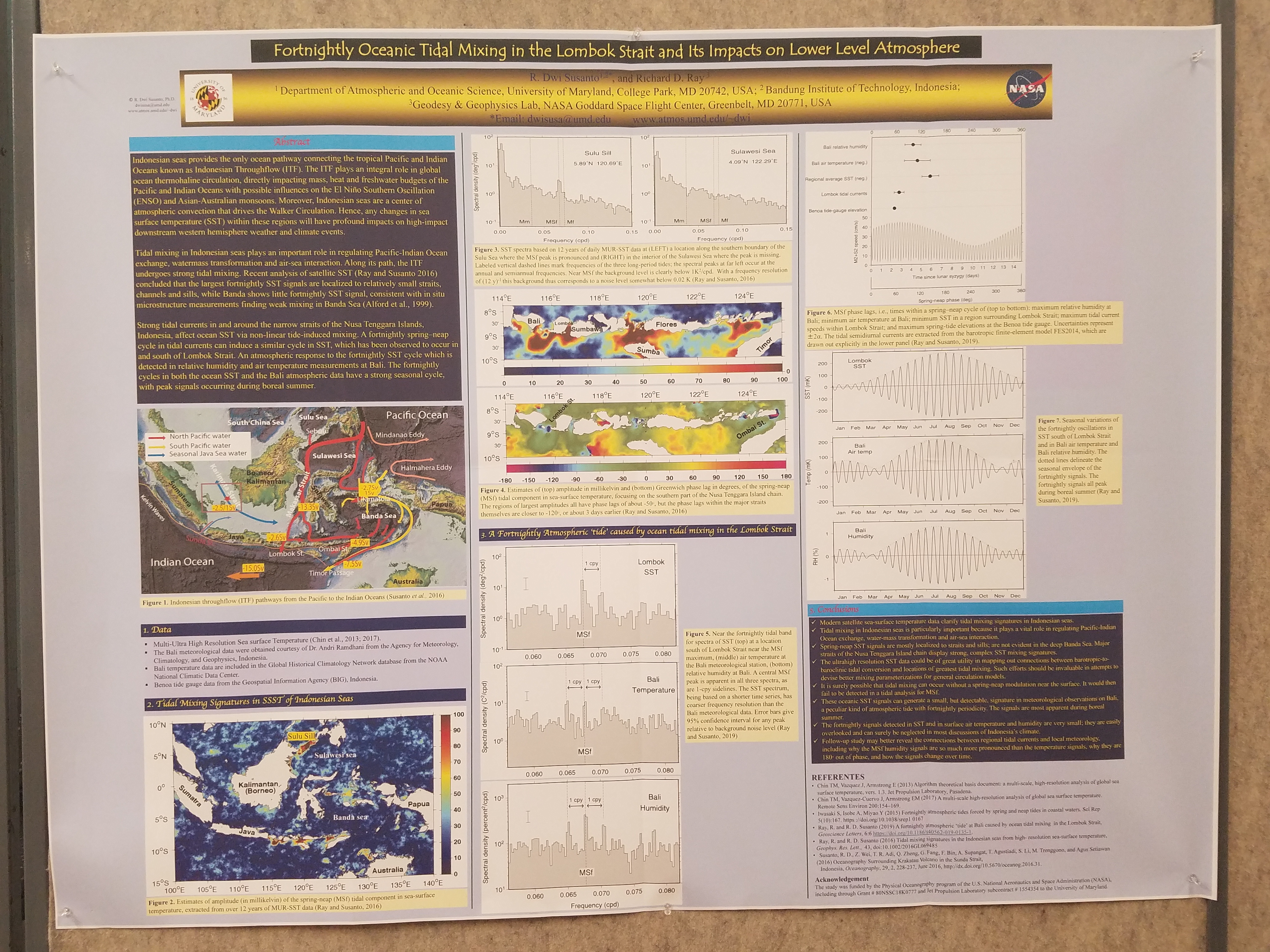
| Fortnightly Oceanic Tidal Mixing in the Lombok Strait and Its Impacts on Lower Level Atmosphere, (JPG, 4.33 MB) |
Dwi Susanto, R. |
University of Maryland |
| Coral Reef Stakeholders' Use of NOAA Coral Reef Watch Ecoforecasts During the 2014-2017 Global Coral Bleaching Event |
Eakin, Mark |
NOAA Coral Reef Watch |
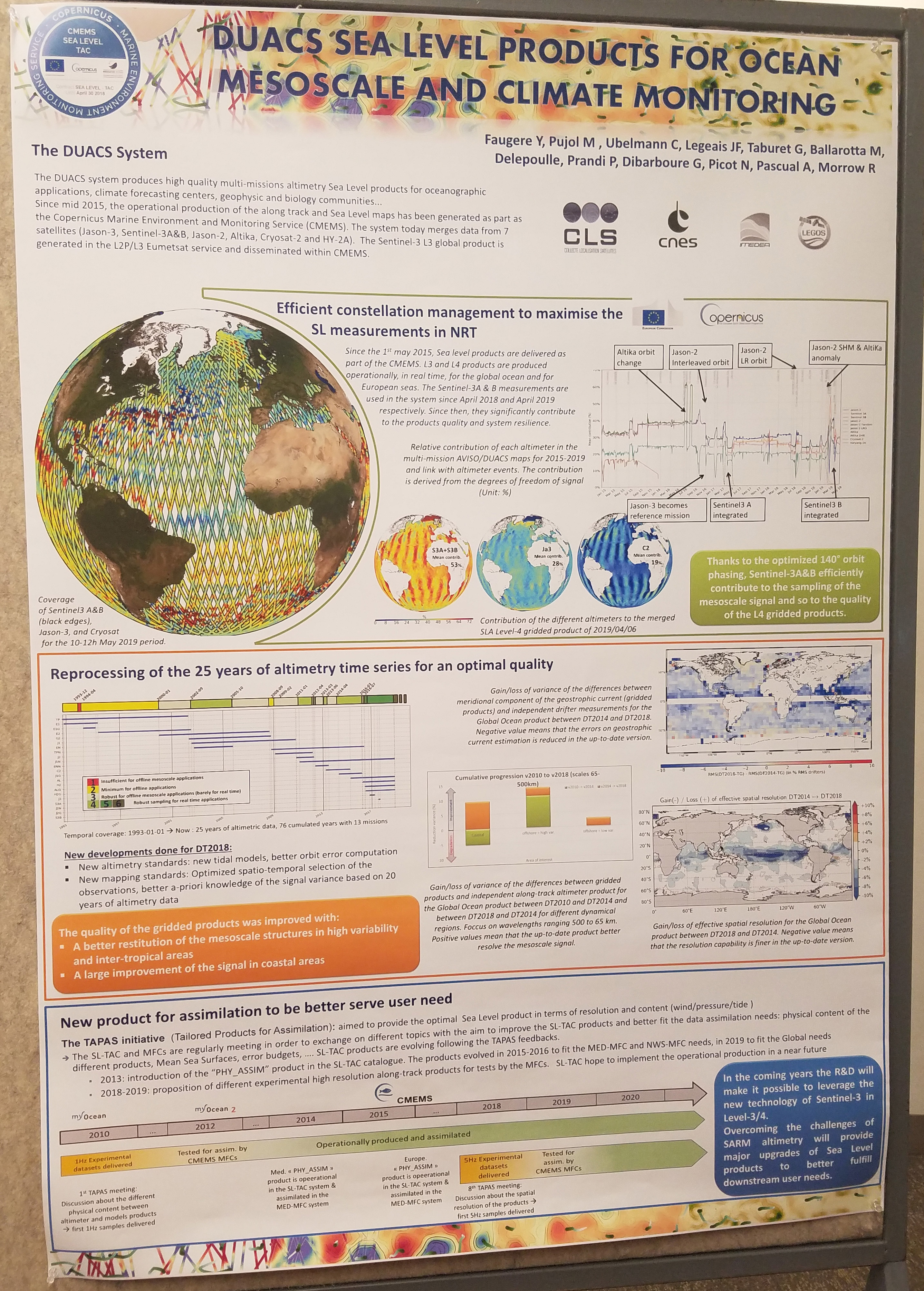
| DUACS Sea Level Products for Ocean Mesoscale and Climate Monitoring, (JPG, 2.79 MB) |
Faugere, Y. |
CMEMS Sea Level TAC |
| Exploring ocean eddy characteristics through the DynEd atlas, (JPG, 1.95 MB) |
Faugere, Y. |
Collecte Localisation Satellites |
| Marine and Coastal Areas Management in Western Africa: A Case of EO Data Application |
Foli, Bennet |
University of Ghana |
| Use of satellite Sea Level Anomaly (SLA) and Sea Surface Temperature (SST) data in operational 4DVAR Ocean Data Assimilation Systems in JMA |
Fujii, Yosuke |
JMA, MRI |
| Visualizations support collaboration and decision making by groups of experts and non-experts alike. They also help to make sense of extremely complex data sets containing thousands of data points,which is often the case inmulti-tiered supply chains |
Gurmu, Sinegiorgis |
NOAA/NESDIS |
| Sea surface roughness effects on aerosol optical depth and water reflectance retrievals from AERONET-OC and ocean color satellite sensors, (JPG, 1.94 MB) |
Herrera, Eder |
NOAA / CREST |
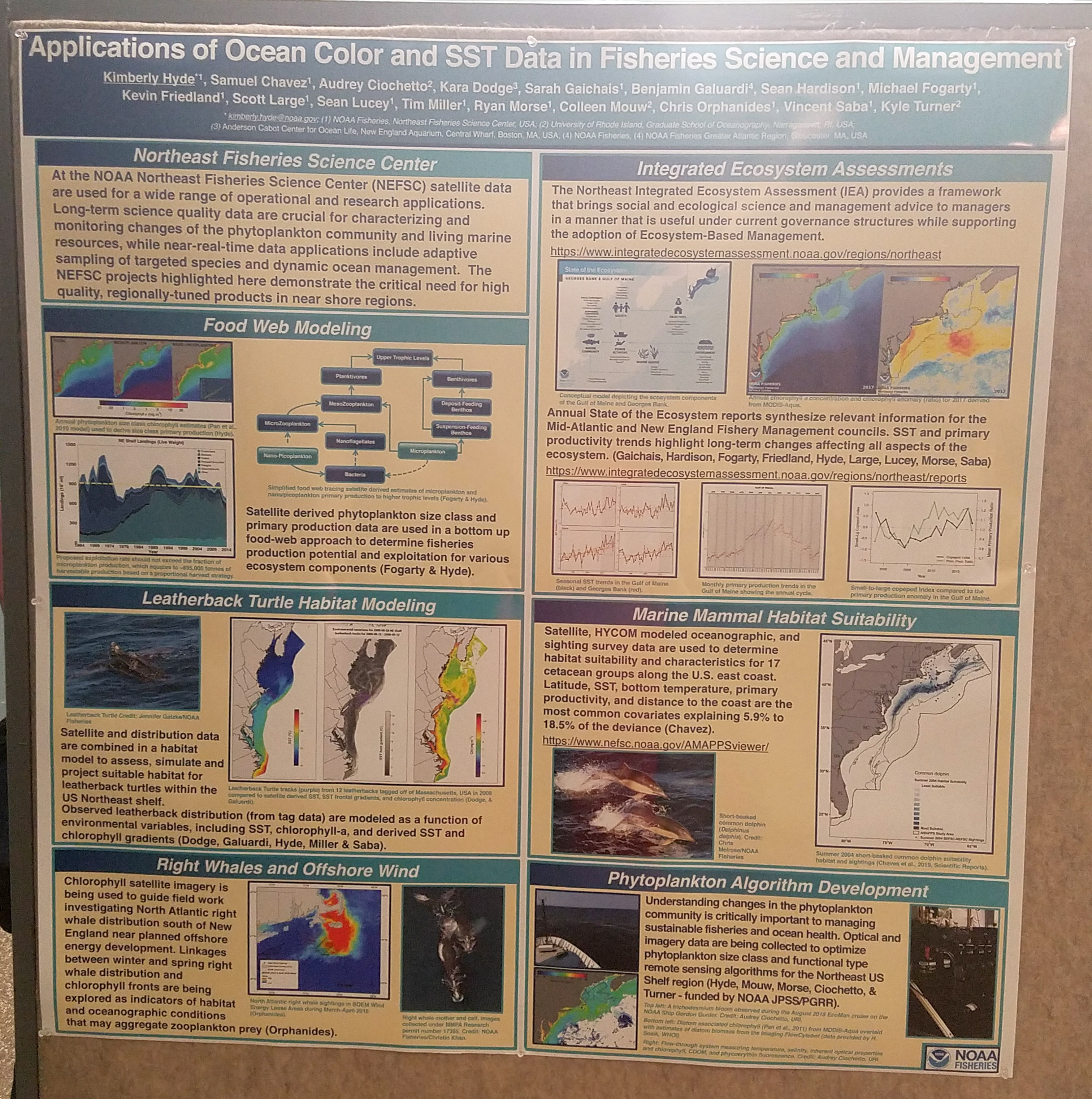
| Applications of Ocean Color and SST Data in Fisheries Science and Management, (JPG, 2.23 MB) |
Hyde, Kimberly |
NOAA Northeast Fisheries |
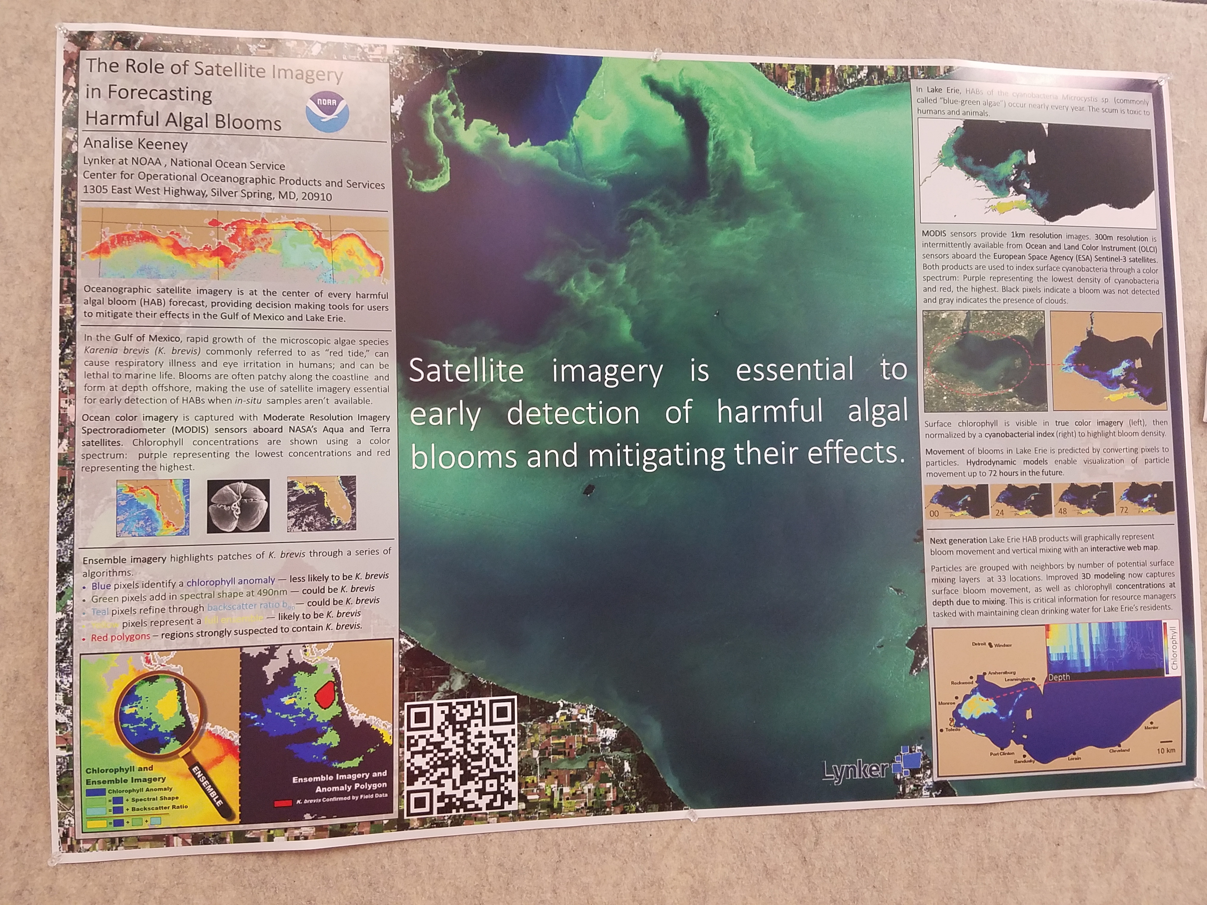
| The Role of Satellite Imagery in Forecasting Harmful Algal Blooms, (JPG, 3.91 MB) |
Keeney, Analise |
NOAA/NOS/CO-OPS |
| Cyclone |
Kelem, Dereje |
Overview of NASA's PACE mission and pre-launch Applications efforts |
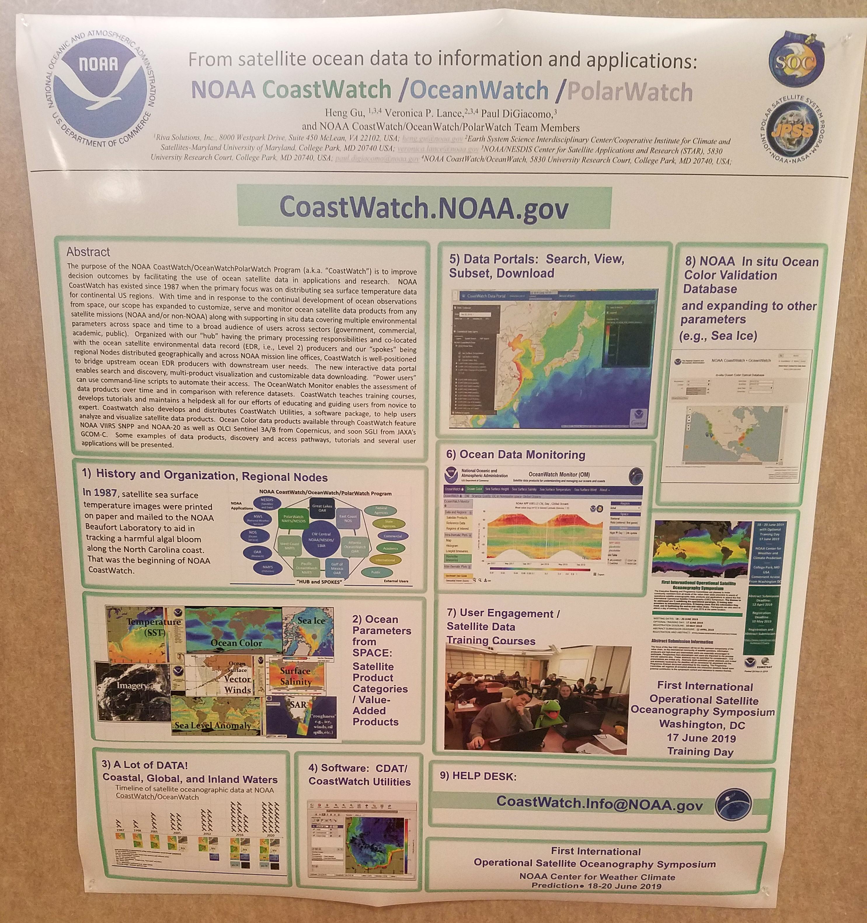
| From satellite ocean data to information and applications: NOAA CoastWatch /OceanWatch /PolarWatch, (JPG, 2.23 MB) |
Lance, Veronica |
NOAA CoastWatch/OceanWatch/PolarWatch |
| The role of satellite oceanographic observations in understanding the dynamics of the Mediterranean and Black Seas in the framework of CMEMS |
Lecci, Rita |
Mercator Ocean International |
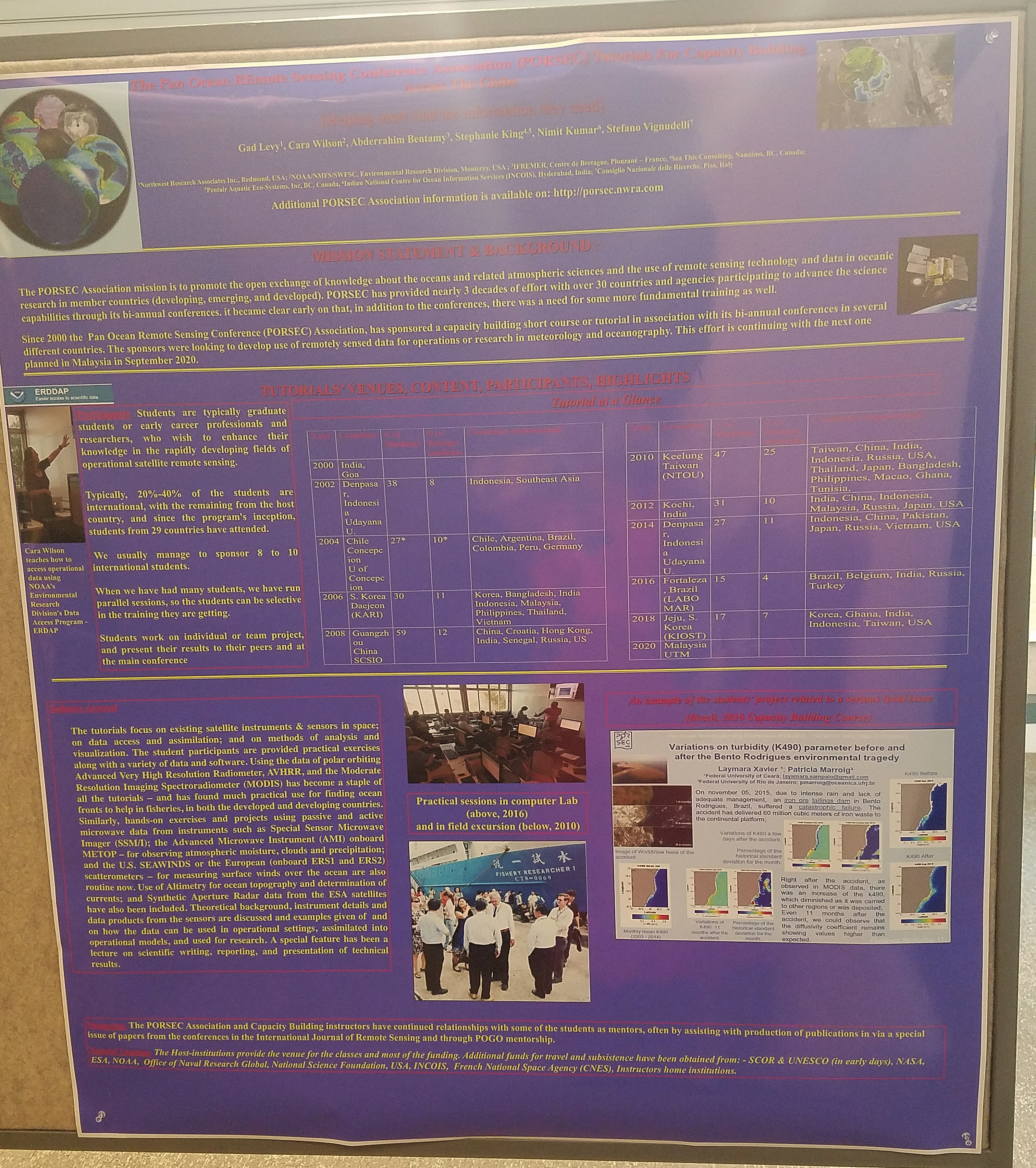
| The Pan Ocean Remote Sensing Conference Association (PORSEC) Tutorials for Capacity Building, (JPG, 3.05 MB) |
Levy, Gad |
Northwest Research Associates |
| NOAA Coral Reef Watch's Operational Satellite Marine Ecosystem Environment Monitoring for Tropical Coral Bleaching Management, (JPG, 4.28 MB) |
Liu, Gang |
NOAA/NESDIS, NOAA Coral Reef Watch |
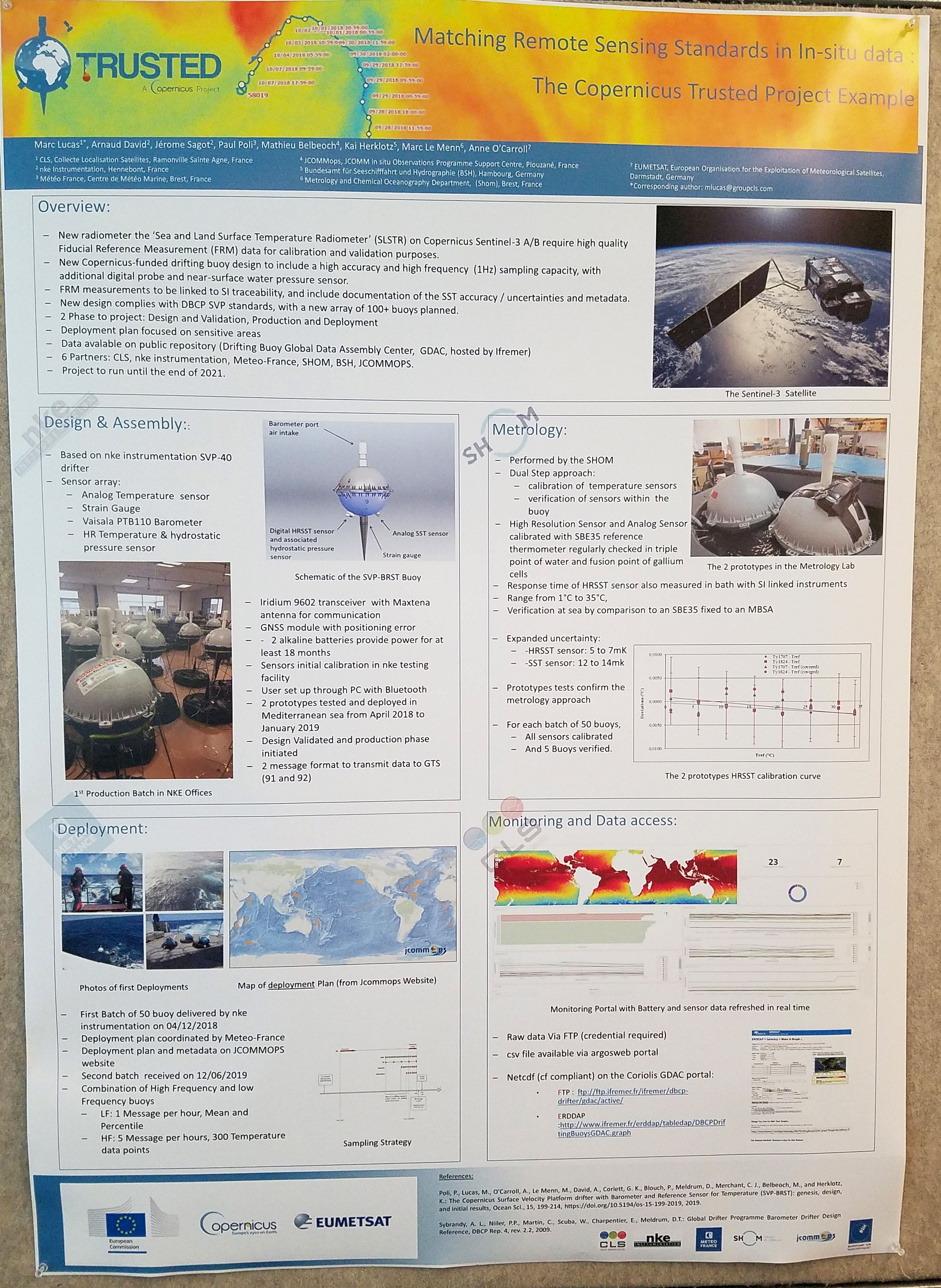
| Matching Remote Sensing Standards in In-situ data: The Trusted Project Example, (JPG, 2.54 MB) |
Lucas, Marc |
Collecte Localisation Satellites |
| Novel Along-track Dynamic Ocean Topography from Cryosat-2 Radar Altimetry used to derive Southern Ocean Surface Circulation and Antarctic Circumpolar Current Frontal Dynamics |
Mackie, Erik |
Cambridge Fluids Network |
| A New High-Resolution Sea Surface Temperature Blended Analysis, (JPG, 1.84 MB) |
Maturi, Eileen |
NOAA |
| Neural Network Reflectance Prediction Model (NNRPM) for both open ocean and coastal waters |
Mukherjee, Lipi |
University of Maryland |
| Future perspectives of using in-situ and satellite data to monitor TC existence and track forecast |
Muleta, Zerihun Bikila |
|
| Spatio-temporal dynamics of phytoplankton functional groups in the South China Sea and their relative contributions to marine primary production |
Ndah, Anthony Banyouko |
Universiti Brunei Darussalam |
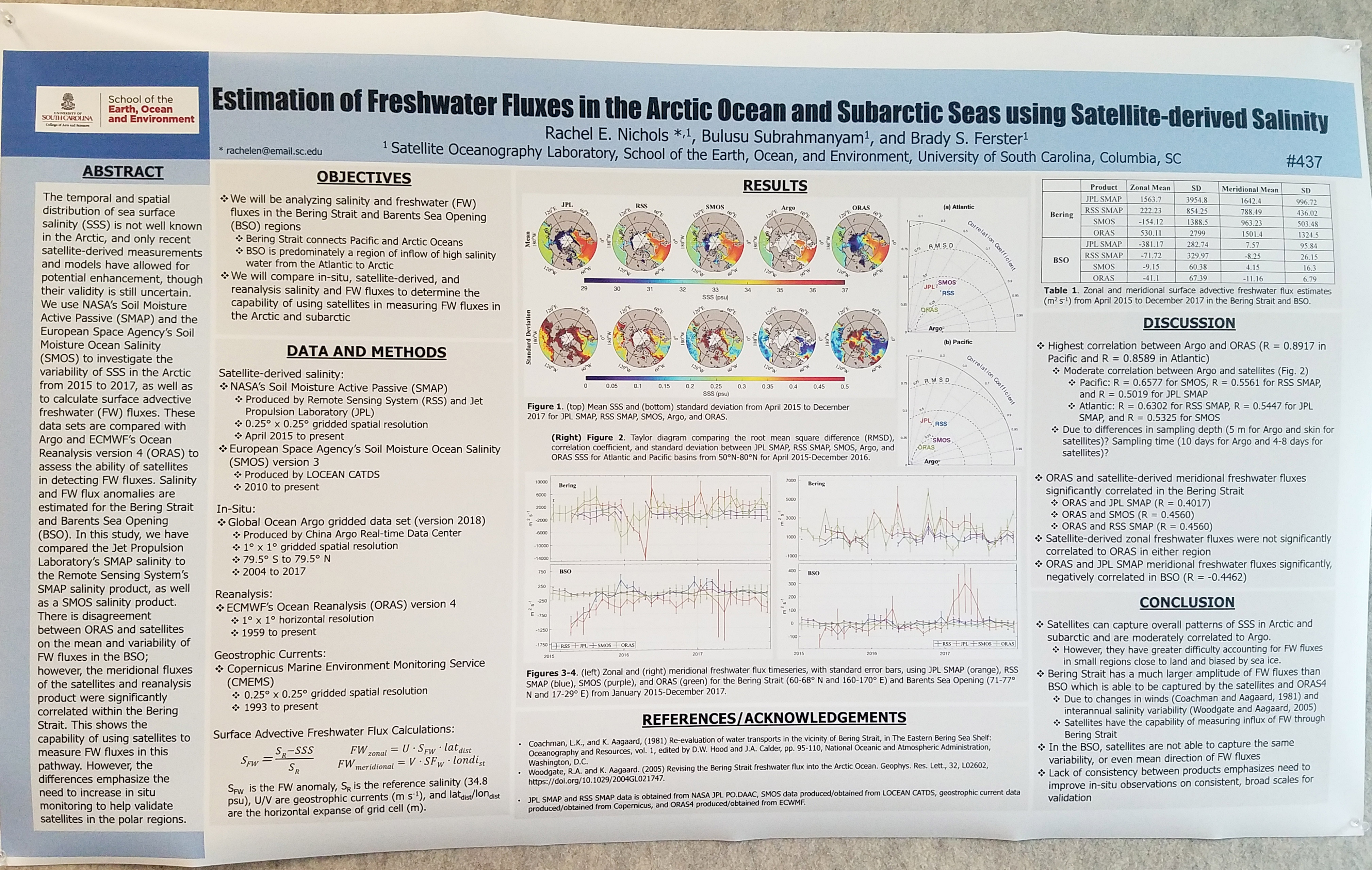
| Estimation of Freshwater Fluxes in the Arctic Ocean and Subarctic Seas using Satellite-derived Salinity, (JPG, 2.39 MB) |
Nichols, Rachel E. |
University of South Carolina |
| Impact of High-Resolution Sea Surface Salinity Observations on Ocean Analysis/Forecast Skill, (JPG, 2.2 MB) |
Nyadjro, Ebenezer |
University of New Orleans |
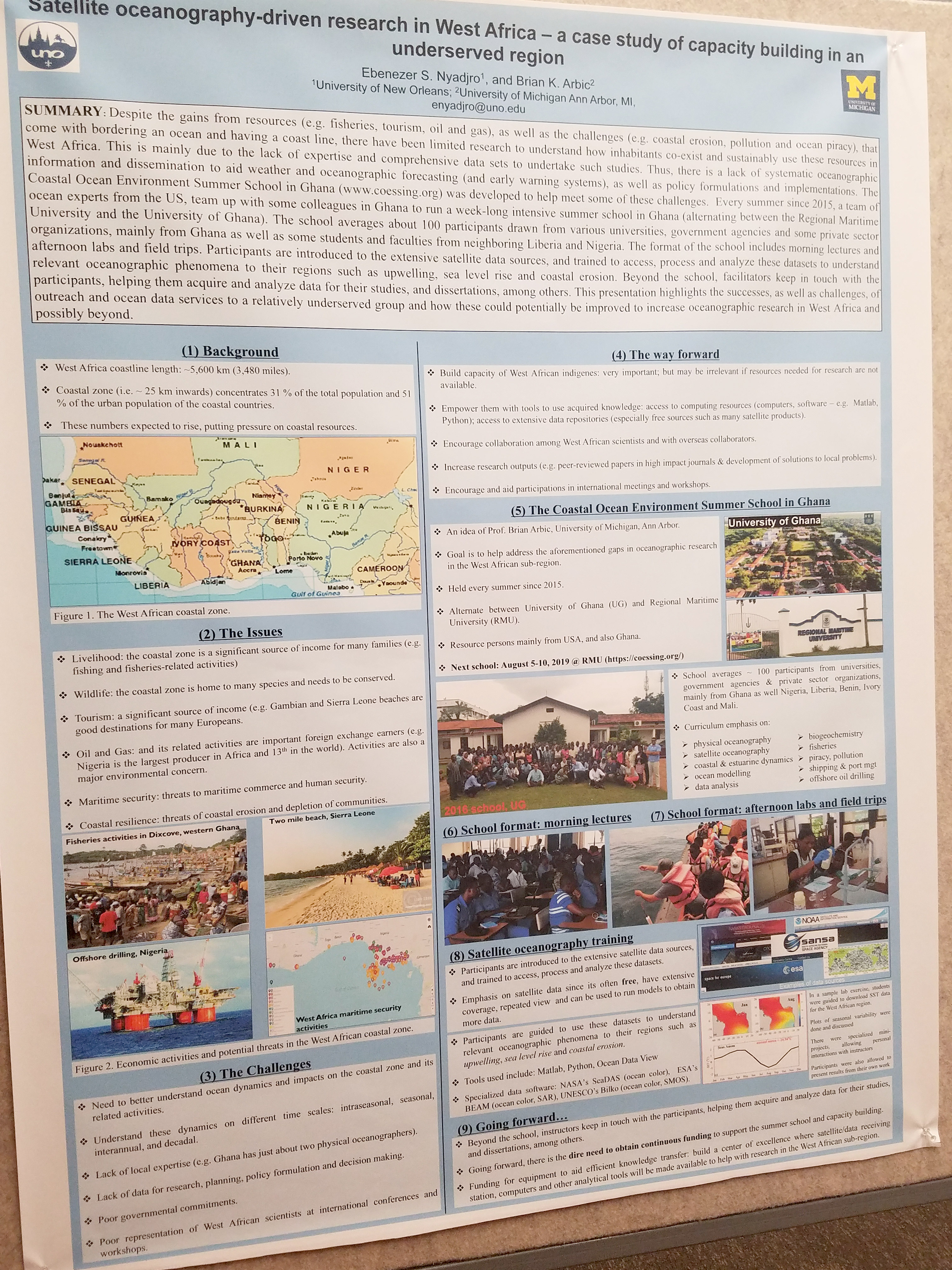
| Satellite oceanography-driven research in West Africa -- a case study of capacity building in an underserved region, (JPG, 2.85 MB) |
Nyadjro, Ebenezer |
University of New Orleans |
| Operational exploitation of sea-surface temperature data retrieved from satellites |
O'Carroll, Anne |
EUMETSAT |
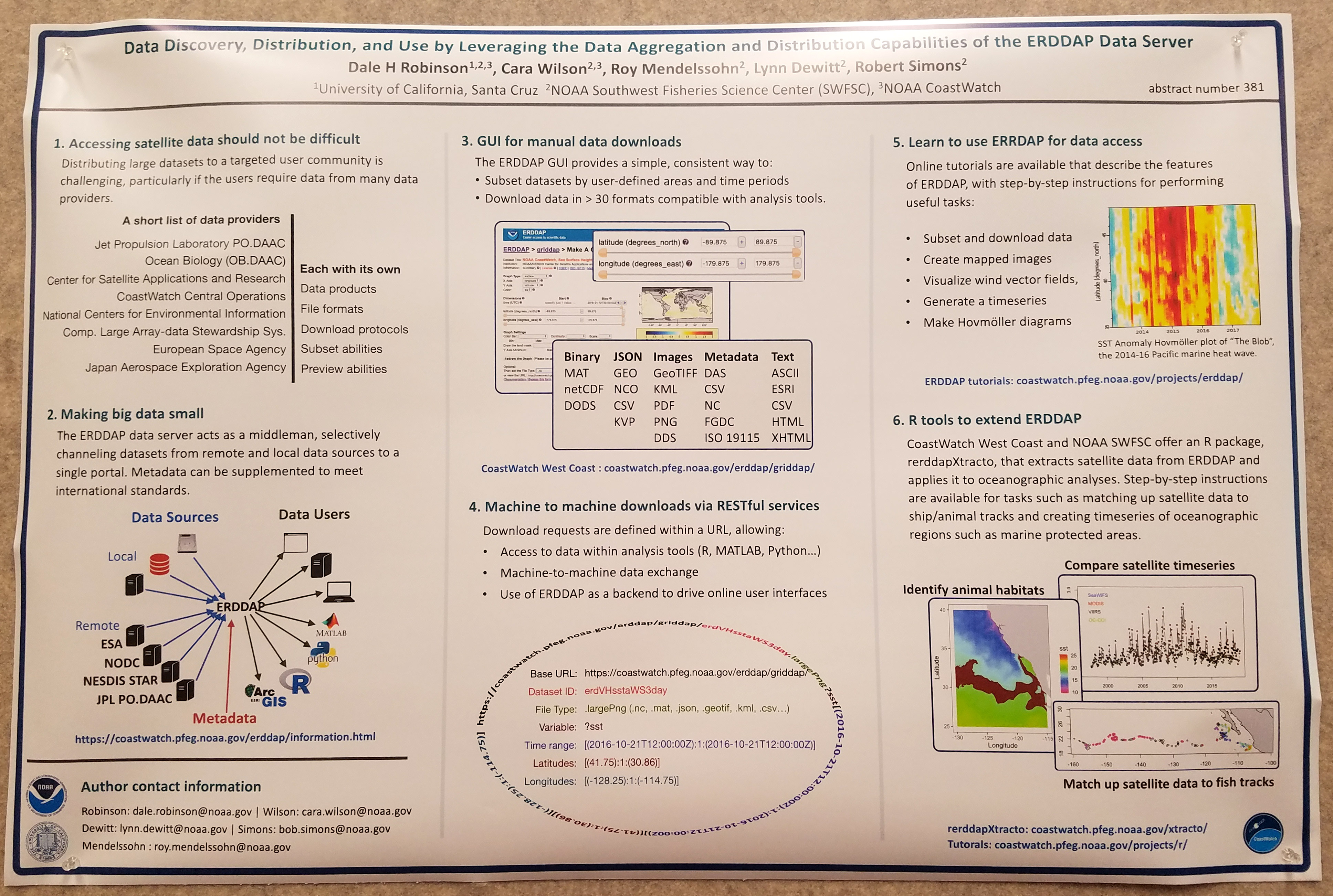
| Data Discovery, Distribution, and Access to Data by Leveraging the Data Aggregation and Distribution Capabilities of the ERDDAP Data Server, (JPG, 1.93 MB) |
Robinson, Dale |
NOAA |
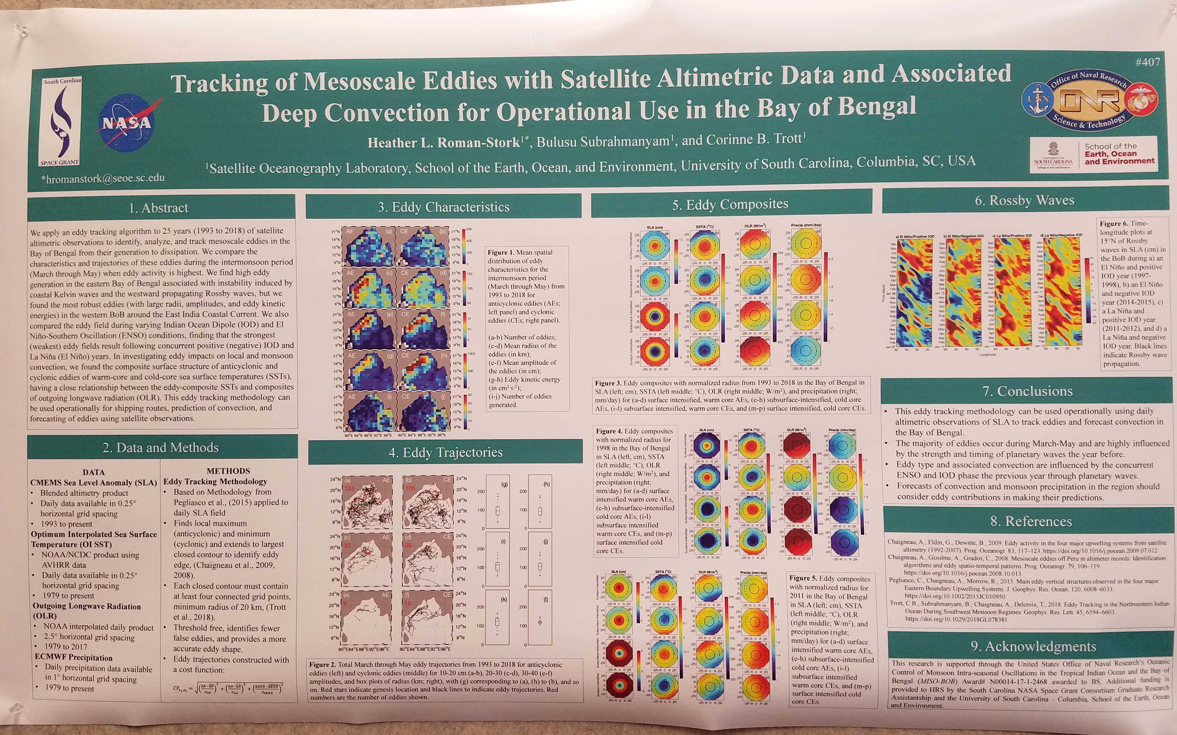
| Tracking of Mesoscale Eddies with Satellite Altimetric Data and Associated Deep Convection for Operational Use in the Bay of Bengal, (JPG, 2.45 MB) |
Roman-Stork, Heather L. |
University of South Carolina |
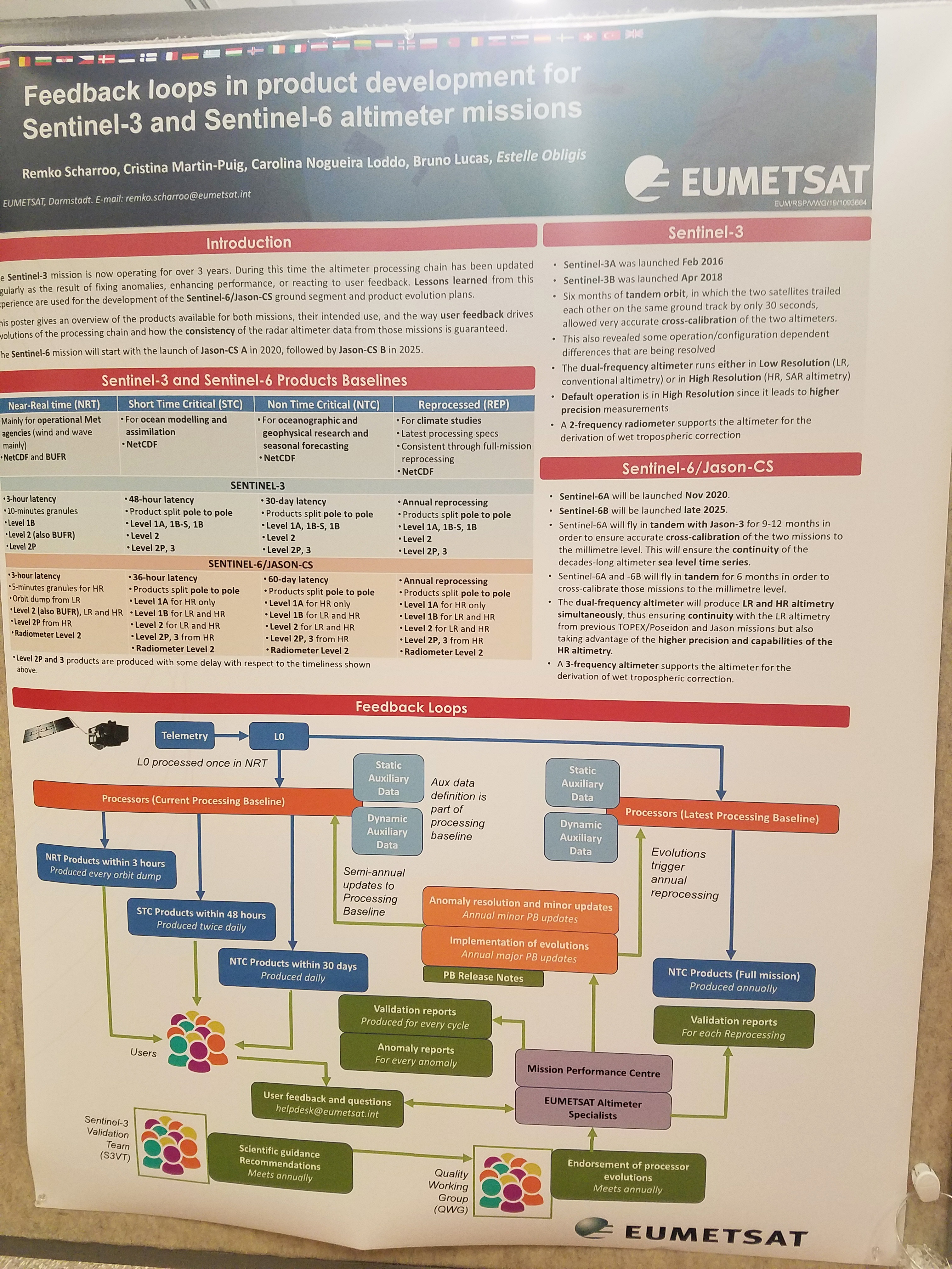
| Feedback loops in product development for Sentinel-3 and Sentinel-6 altimeter missions, (JPG, 2.58 MB) |
Scharroo, Remko |
EUMETSAT |
| Collaborative Design of Mid-Stream Satellite and Forecast Information Systems, (JPG, 1.88 MB) |
Strub, Ted |
Oregon State University |
| Spring-neap Tidal Mixing Signatures from High Resolution Satellite-Derived Sea Surface Temperature Data, (JPG, 4.33 MB) |
Susanto, Raden Dwi |
University of Maryland |
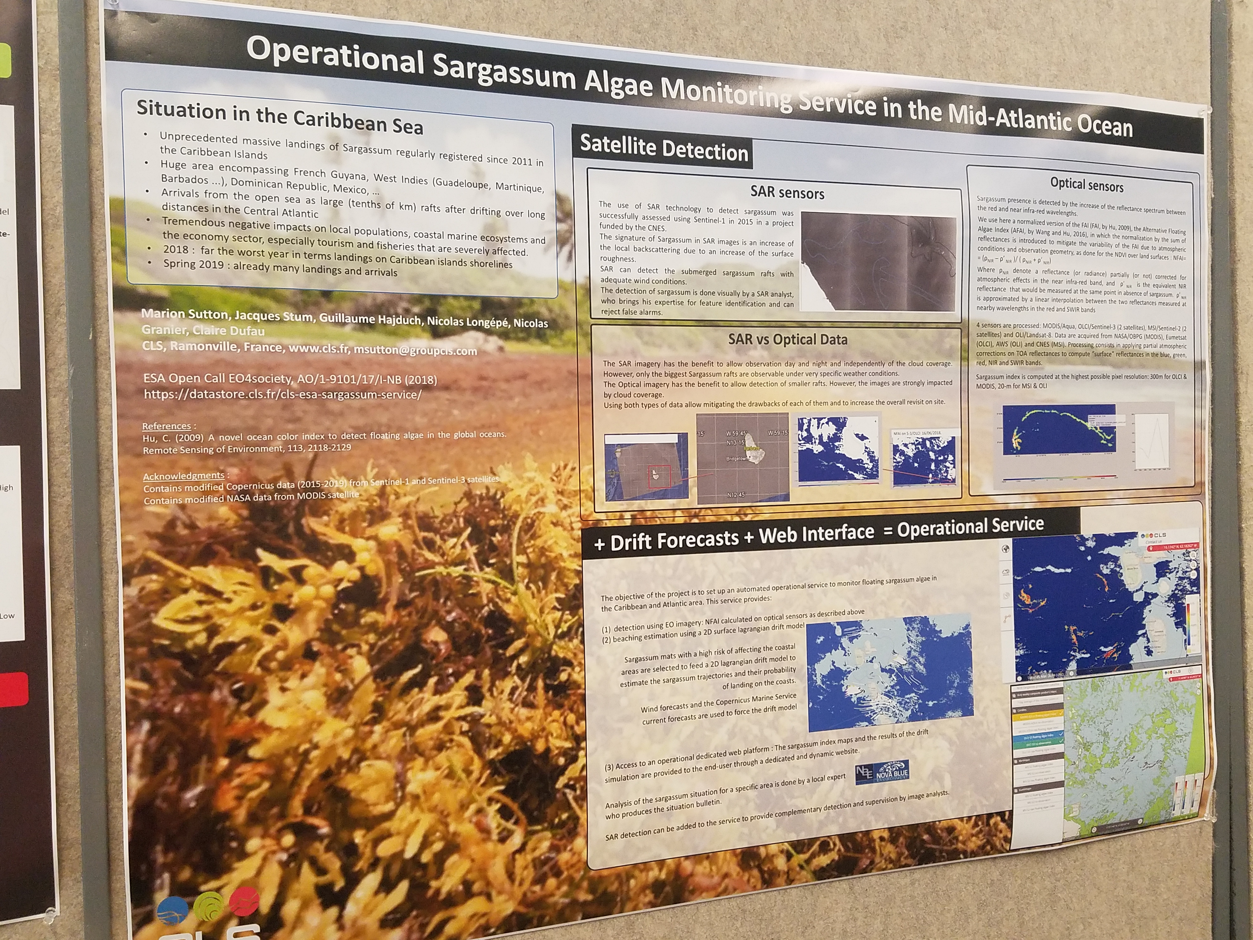
| Operational Sargassum Algae Monitoring Service in the Mid-Atlantic Ocean, (JPG, 4.43 MB) |
Sutton, Marion |
CLS |
| Satellite Based Products and Services at National Meteorology Agency (NMA) |
Tesfatsion, Yitaktu |
NMA |
| The impact of climate change on vegetation in Ethiopia over some selected areas |
Tesfatsion, Yitaktu |
NMA |
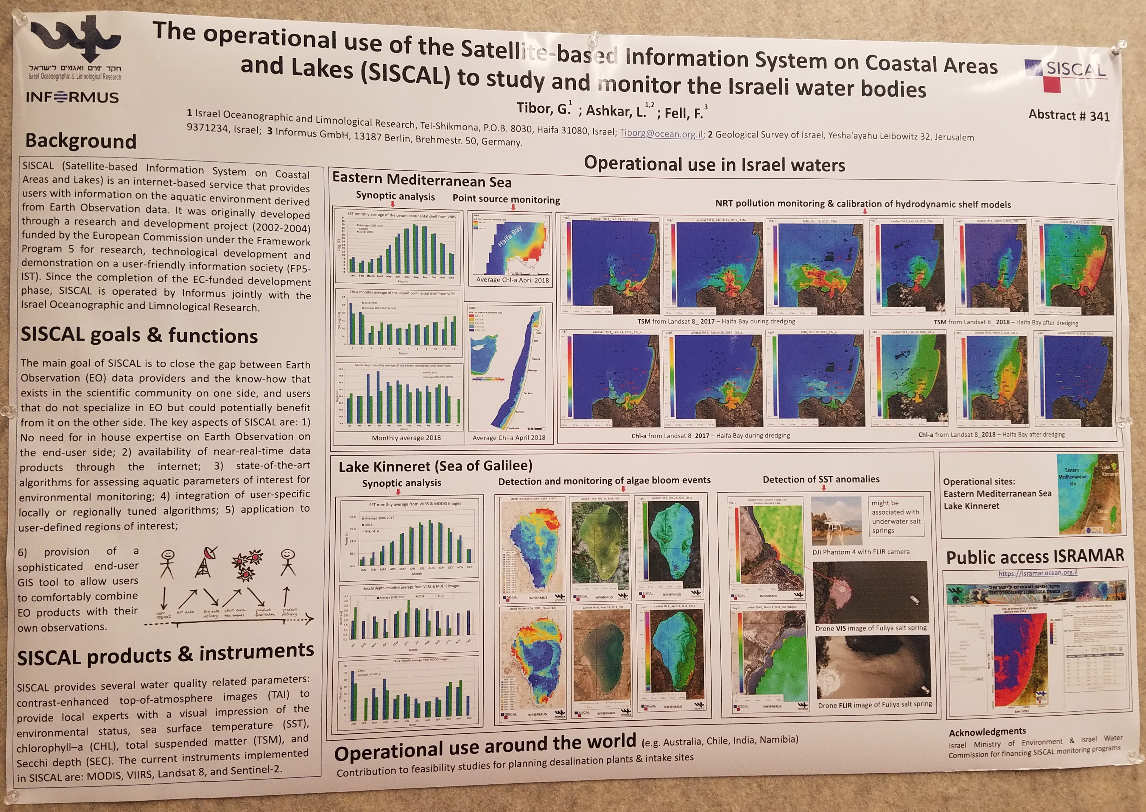
| The operational use of the Satellite-based Information System on Coastal Areas and Lakes (SISCAL) to study and monitor the Israeli water bodies, (JPG, 2.53 MB) |
Tibor, Gideon |
IOLR |
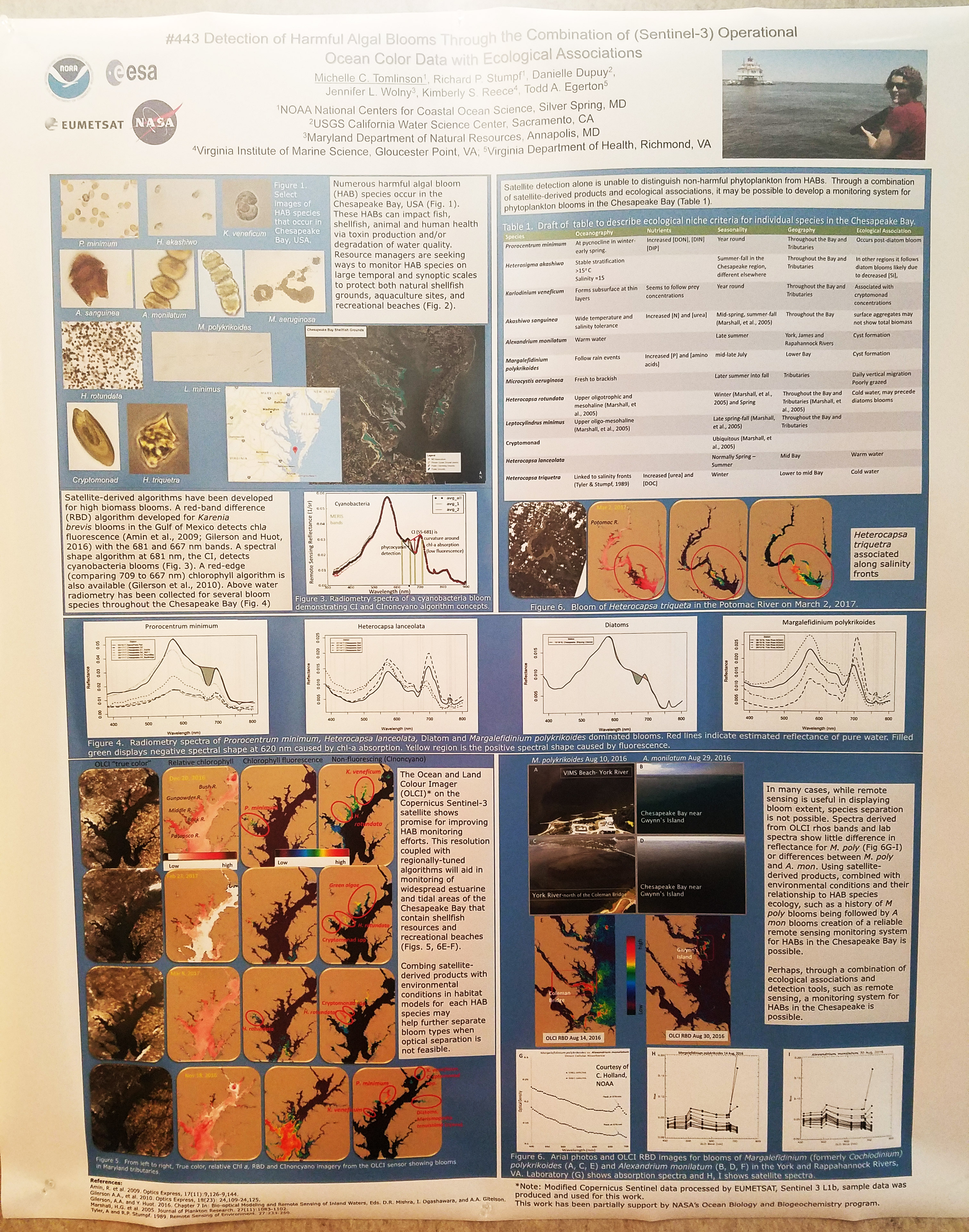
| Detection of Harmful Algal Blooms Through the Combination of (Sentinel-3) Operationa Ocean Color Data with Ecological Associations, (JPG, 3.14 MB) |
Tomlinson, Michelle |
NOAA NCCOS |
| ASCAT - from data to applications, (JPG, 2.02 MB) |
Linow, S. |
EUMETSAT |
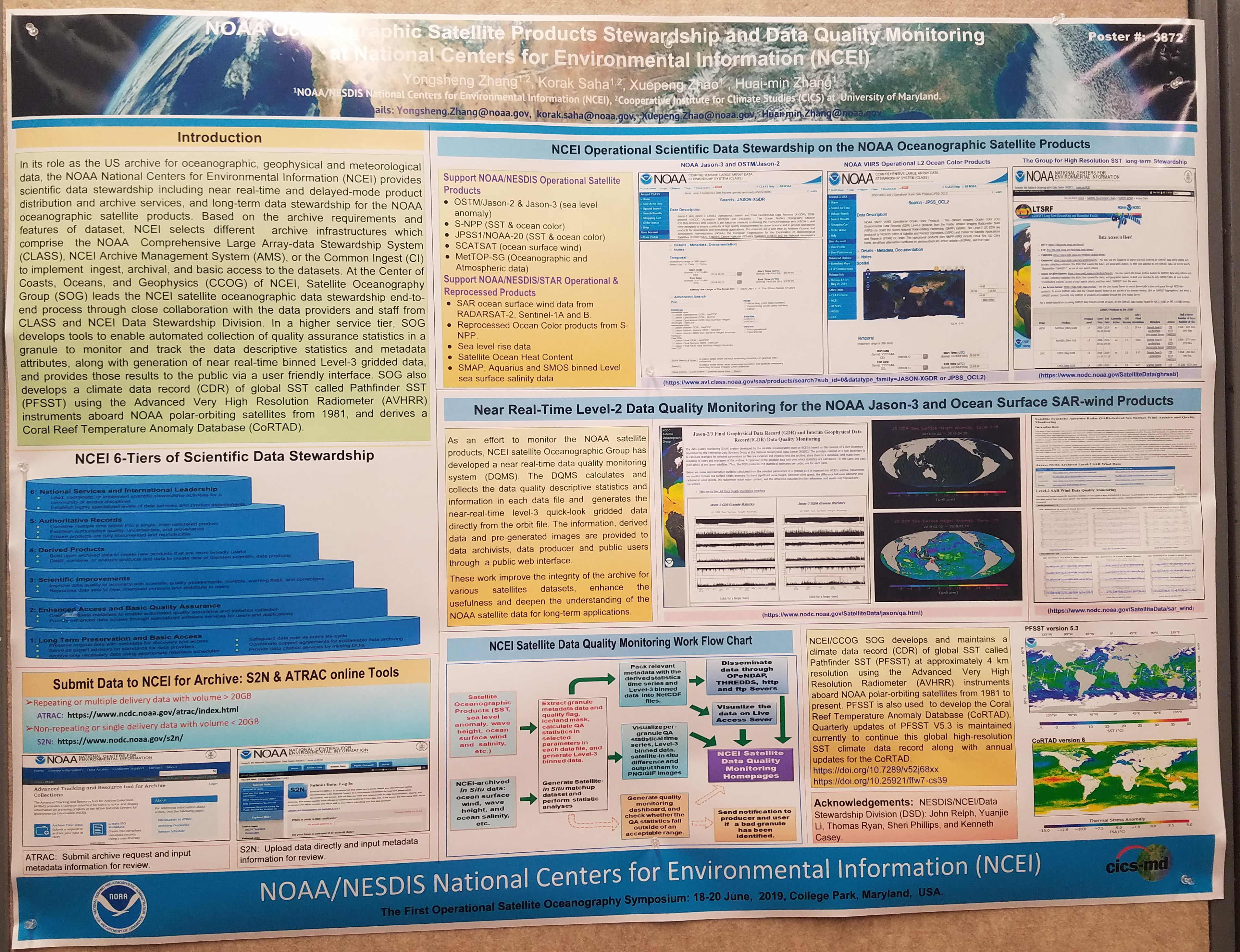
| NOAA Oceanographic Satellite Products Stewardship and Data Quality Monitoring at National Centers for Environmental Information (NCEI), (JPG, 2.97 MB) |
Zhang, Yongsheng |
NOAA NCEI |
|
