NOAA Center for Satellite Applications and Research banner
 
Ocean Winds Field Experiment Program

The NESDIS Ocean Winds Field Experiment Program is an ongoing effort with the objectives:

  • Provide calibration and validation of satellite ocean surface vector wind (OSVW) retrieval performance in limiting environmental conditions, such as high winds with and without the presence of precipitation.
  • Improve satellite OSVW retrieval performance and understanding. For example, currently ASCAT OSVW retrievals are not detecting hurricane force wind conditions which QuikSCAT consistently revealed. In order to provide as much continuity as possible to support NWS services and products we need to ascertain whether this ASCAT limitation can be overcome, and the field experiment is an important part of this effort.
  • Provide risk reduction by testing and evaluating new remote sensing technologies and techniques. For example, the results of NESDIS Ocean Winds experiment program was the basis for the dual-frequency design of next generation scatterometer (XOVWM) and dual-frequency scatterometer designed by JPL for JAXA's GCOM-W mission to achieve improved wind vector retrieval performance.

Research Instrumentation & the Program's Summer Component

During the summer component, the NESDIS Ocean Winds program is integrated with Hurricane Intensity Forecast Experiment (IFEX) and the Hurricane Forecast Improvement Project (HFIP) and works closely with the AOML/Hurricane Research Division. The main instrumentation utilized is the Imaging Wind and Rain Airborne Profiler (IWRAP) which is a C-band and Ku-band profiling radar system capable of measuring the surface radar cross-section in addition to profiles of reflectivity and doppler velocity in the presence of precipitation. IWRAP was designed and built by the University of Massachusetts at Amherst (UMASS). UMASS graduate students participate in flight experiments operating IWRAP and in the post-experiment processing and analysis of the collected data. We also utilize other standard measurements provided by the NOAA P-3 platform which include the Stepped Frequency Microwave Radiometer (SFMR), which was originally developed at UMASS, GPS dropsondes, aircraft position information, and other variables.

decorative border

NESDIS Ocean Winds Field Experiment Program

N43 propeller with icicles

Joe Sapp, Zorana Jelenak and Paul Chang monitoring data at station 7 on N43
See the other trip photos

February 22, 2010 - At the AMS Banquet in Atlanta last month, Paul Chang was honored along with co-researchers for "an exceptional, interdisciplinary project, resulting in continuous operational monitoring of hurricane surface winds, improved hurricane intensity advisories, and saving countless lives." But Paul wasn't at the AMS to receive this award. He was on his way to Newfoundland to work on the NESDIS Ocean Winds Field Experiment.

The NESDIS Ocean Winds Field Experiment program generally consists of a summer and winter component, where the winter component focuses on extratropical storms in the North Atlantic or North Pacific and the summer component focuses on tropical cyclones. The NESDIS Ocean Winds Flight Experiment Program flight hours are supported out of OMAO's budget as one of the core annual P-3 programs. STAR personnel, Paul Chang and Zorana Jelenak planned and executed the missions while Joe Sapp and Jason Dvorsky, UMASS graduate students, operated remote-sensing equipment. NOAA Aircraft Operation Center (AOC) personnel and resources are a key piece of the success of the program. On our current deployment in St. Johns Newfoundland AOC has 15 personnel deployed to support the flights.


ASCAT High Wind Speed Retrieval Product

Currently Operational ASCAT Wind Vector Retrievals

Currently Operational ASCAT Wind Vector Retrievals


New ASCAT Wind Vector Retrievals

New ASCAT Wind Vector Retrievals


The two images above are ASCAT wind vector retrievals coinciding with our February 2nd flight. They both have the flight track and a sample validation observation indicated. One plot is the current operational ASCAT wind vector retrievals while the other is a new and improved ASCAT high wind speed retrieval scheme that Seubson (Golf) Soisuvarn has been working on in our group.

The NWS is very interested in this product, since it could improve their ability to continue some of the marine wind warning and forecasting products that they relied upon QuikSCAT for (QuikSCAT ceased nominal operations in November 2009). We were able to validate on several of our flights that Golf's new ASCAT retrievals were indeed more accurate at high wind speeds than are the current ASCAT wind retrievals being used operationally today.


Trip Notes

Paul sent out trip notes to his STAR colleagues, and along with the photographs, they give a fascinating front-row seat on NOAA wind research.

Ocean Winds Survey - Installment #1 - 31 January 2010

photo: aircraft de-icingWe arrived in St Johns, Newfoundland aboard the NOAA P-3 N43RF Wednesday (1/20) evening. It was a nice clear evening so weather at landing was not a problem. The following day brought several inches of snow and, after a project kick-off meeting at the airport FBO that morning, we spent the rest of the day working on IWRAP, which had exhibited some problems during the ferry flight. The problems were eventually isolated to two bad cable connections and a PCI A/D card that had worked itself loose over time.

We planned and executed our first mission into a storm in the North Atlantic on Saturday with the meteorological help/guidance of Joe Sienkiewicz (OPC). For this 6 hour flight, we managed to takeoff around 630pm (scheduled 530pm) after some problems with the aircraft data systems and an extended de-icing session. Since we weren't timing a satellite overpass the later takeoff didn't cause any problems. A quick look at the data after our return revealed some potential issues with the two channels that we installed frequency synthesizers to permit varying the incidence angles.

Sunday afternoon we did some additional testing with IWRAP to better understand what was happening at the outer incidence angles. Monday was declared a hard-down data to reset the 7 day clock. We currently have planned a day-time flight for Wednesday (1/27) in the Labrador sea region to coincide with an Oceansat2 overpass. Tuesday we have planned a few hours of work on IWRAP to prepare for Wednesday's flight. The attached picture is N43 parked in our spot at the airport. We are supposed to be parked right in front of the FBO building but a broken USAF C130 that is awaiting a replacement prop is currently parked there. It's been below freezing since we arrived with temps about -10°C at night which results in an extended equipment warmup time.

Ocean Winds Survey - Installment #2 - 2 February 2010

Hi All, Sorry for the delay in getting the next Ocean Winds update out. We had a very nice flight last Wednesday (1/27) into a storm in the Labrador sea area. We sampled large areas of 20-25 m/s winds under cold SST conditions. We coordinated with an ASCAT and Oceansat2 overpass. The flight was approximately 6 hours and IWRAP behaved well. We did some testing of various incidence angles at the end of the flight and based on that test we made some changes to the IWRAP configuration. The current IWRAP configuration is as follows:

IWRAP Configuration
C-band Ku-band
  • CH2 (synthesizer set at 4.98GHz) running without the Rx 5.01 GHz BPF (75 MHz bandwidth) because the Tx freq would actually be 4.95 GHz and outside the range of the BPF
  • CH1 use the 5.23 GHz DRO which is about ~35°
  • CH2 (synthesizer set at 12.6 GHz (or 12.5 with larger cal pulse oscillations?) without an RX BPF filter because it is outside of the passband
  • CH1 use the 13.53 GHz DRO which is about ~35°

We are also operating in chirp-chirp mode (versus pulse-chirp) for both frequencies and flying at 8K feet during our operations.

We also had a flight on Monday (2/1) into a rapidly developing storm NE of St Johns (south of Greenland). We were over an hour late in taking off because of some aircraft issues that the maintenance folks scrambled to rectify. I don't think Miss Piggy (N43) likes the cold! We also had some minor de-icing....certainly much less than the $16K that our first flight required. This was a maximum duration mission of approximately 8 hours with a landing at St Johns at approximately 130am on 2/2. We encountered winds in the 20-27 m/s range and IWRAP behaved very nicely. We coordinated with an ASCAT and Oceansat2 overpass. Incidentally, from looking at the ASCAT data coincident from our last few flights, Golf's improved GMF retrievals appear to match what we saw in-flight much better than current operational ASCAT retrievals.

We had a second flight planned for Tuesday (2/2) into the same storm but opted to pull the plug on that flight to focus on a storm forecast for Thursday and Friday which is looking impressive. This is the same system that brought snow to the DC area last night. The maintenance folks conducted the required 50 hour maintenance during the course of yesterday and today which will permit us two do two flights in a row. Attached is the OPC 48 forecast valid at 00Z on 2/5 depicting the storm we will be going after tomorrow.

Ocean Winds Survey - Installment #3 - 13 February

N43 at airfield, as snow intensifies - photo #1N43 at airfield, as snow intensifies - photo #2
N43 at airfield, as snow intensifies - photo #3N43 at airfield, as snow intensifies - photo #4

Watching the N43 ("Miss Piggy") Disappear During the Blizzard February 5, 2010

On Thursday February 4th we had a fantastic flight into a major extratropical cyclone with hurricane force winds. We successfully sampled large regions of storm to hurricane force winds. It was a maximum duration mission which is approximately 8 hours for deployment. IWRAP behaved very nicely and the flight track planning we did, with great assistance from Joe Sienkiewicz at OPC, worked beautifully so in some sense it was almost an easy flight if one considers 3 hours of pre-flight and 8 hours of flight time in a P-3 easy. However, our plan to fly this storm a second day didn't quite work out as planned. We had planned for a 1530 local time takeoff on Friday but storm we flew the previous day had broadened and brought less than ideal flying weather over St Johns (see pics).

We all mustered at the airport at 1230 local to see if the weather might let up for us to takeoff but after waiting for about an hour with conditions continuing to deteriorate we pulled the plug on the Friday mission. Between a quiet period of weather and some unforeseen delays in Canadian customs to get some required parts for N43, our next flight was the following Thursday February 11. This storm was the one that brought the second batch of snow to the Washington DC area on Tuesday/Wednesday. It was also forecast to reach hurricane force strength out over the Atlantic. However, it was positioned a little to far south for us to be able to reach the region of the highest winds, but we did sample a 27 m/s wind with one of the GPS dropsondes we deployed. One really nice thing with this storm was that for much of the flight track we could see the surface. There was very little in the way of precipitation but we measured surface winds covering the range from calm to all the way to storm force.

This flight should prove to be a very useful one for our scatterometer and SFMR wind retrieval studies. We had originally planned on a second flight into this storm system, but by Friday it had weakened considerably and the weather at St John's airport was approaching minimums required for takeoff. So we opted to cancel the flight and focus on Sunday and Monday which forecast the storm that brought snow to the Southern part of the country yesterday to be a hurricane force storm in the Atlantic just south of St. Johns.

Ocean Winds Survey - Installment #4 - 22 February 2010

photo: Ice on the N43 propellerThis is the final update of the Ocean Winds winter 2010 field experiment. We conducted two consecutive flights Sunday (2/14) and Monday (2/15) into a predicted hurricane force storm in the Atlantic south of St. John's. On Sunday the storm was a little further south than forecast so we weren't able to fully sample the southern portion of the storm as originally planned. However, we did find marginal hurricane force winds. One nice thing about this flight was that for the most part we were free of precipitation and could visually see the ocean surface.

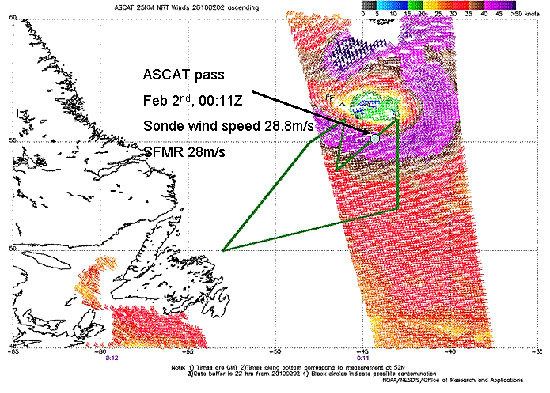
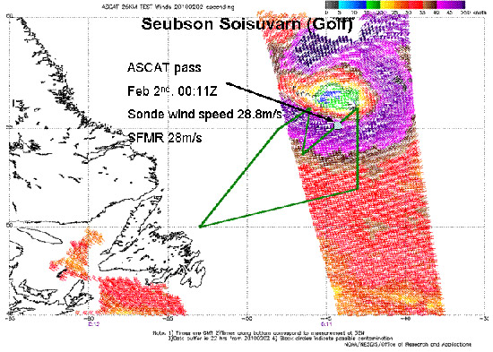
On Monday the storm had moved so that it was more to the east-southeast of St. John's. We found the strong storm-force winds that we were expecting, but the region of storm-force winds was significantly larger than the forecast models were predicting. Both flights were excellent data flights. For Sunday's flight we did have to de-ice again which did surpass our previous de-icing bill and totaled about $25K. During the final third of Monday's flight we did lose the radar return from both channels of the C-band portion of IWRAP. We did some debugging during the final portion of the flight. The calibration pulse and noise floor appeared normal for both channels so we focused our efforts on the power amplifier box. We made some power measurements with the power meter to try ascertain where the problem might be. However, there wasn't enough time track down the problem that day so we opted to take a few collected data files to examine back at the hotel.

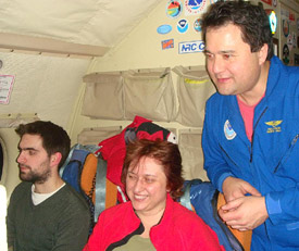
The following day (Tuesday) was a hard-down day and most of the crew decided to try their hand at curling. We rented two sheets of ice at the St. John's curling club for a few hours and had a blast. The following day we went back out to the plane to dig a little deeper into the IWRAP C-band issue. We had a final flight planned for Thursday into the Labrador Sea area to fly some calibration patterns in a large consistent area of gale force winds associated with a passing storm. This flight was also coordinated with an Oceansat2 overpass as was Monday's flight. With IWRAP we found that the cable going from the power amplifier to the antenna had worked its way loose at the rotary joint. There appeared to be a bracket that was preventing the tightening of the connector so we opted to remove the bracket.

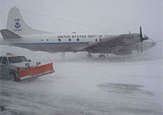
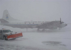
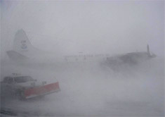
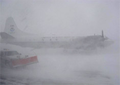
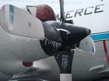
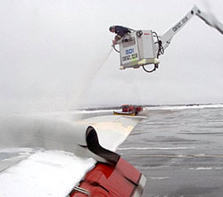
When we showed up Thursday morning for our last flight, N43 was a little bit of a popsicle. Three days of rain and fog with temperatures hovering just around freezing was not a good thing. $44K later "Miss Piggy" was looking much happier, but of course after $44K she had better be happier! The two things that made us feel a little better about the cost were that we would need to get rid of that ice eventually to go home in a few days (temperatures were not forecast to rise) and that the Air Force C-130 ahead of us spent $58K to de-ice. It was also great data flight with the Oceansat2 overpass and the calibration flight patterns. We still had problems with the C-band side of IWRAP. It turns out that rotary joint failed structurally, which might have been helped along by the removal of the bracket that was preventing us from fully tightening the RF cable connector.

The flight otherwise went off without a hitch and we planned for a pack-out data on Friday and a departure for Tampa on Saturday. However, during the flight back to St John's a small section of de-lamination in the co-pilot's window was noticed. The P-3 was subsequently downed until repair which meant at least a week delay in departure. On Friday, plans were made to send most of the crew home via commercial carrier on Saturday. "Miss Piggy" will return to Tampa after a window replacement with a minimum crew, hopefully by the end of the week. Jason and Joe (UMASS) will coordinate with return of N43 to Tampa for about two days of post-experiment calibration measurements and equipment uninstalls.

The Ocean Winds 2010 winter experiment was a very successful project. Many thanks to the great crew at AOC!