
STAR / SMCD / EMB Aerosol Remote Sensing
NESDIS Aerosol Products
This site provides a brief overview of the operational aerosol data produced at NOAA / NESDIS. Depending on the type of the satellite orbit there are two products. They are aerosol data from polar satellites and aerosol data from geostationary satellites.
Aerosol Data from Polar Satellites
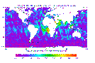 NOAA
/ NESDIS has been routinely estimating aerosol amount over the world's
oceans from the Advanced Very High Resolution Radiometer (AVHRR)
onboard the NOAA polar orbiting operational satellites. The products
are daily, weekly, and monthly global one-degree maps of Aerosol Optical
Thickness. (Read more ...)
NOAA
/ NESDIS has been routinely estimating aerosol amount over the world's
oceans from the Advanced Very High Resolution Radiometer (AVHRR)
onboard the NOAA polar orbiting operational satellites. The products
are daily, weekly, and monthly global one-degree maps of Aerosol Optical
Thickness. (Read more ...)
Aerosol Data from Geostationary Satellites
 Aerosol
optical depth (AOD) has also been routinely retrieved for the contiguous
U.S. (CONUS) from the Geostationary Operational Environmental Satellite
(GOES) satellites. The product is known as the GOES Aerosol and Smoke
Product (GASP). It has retrievals for nominal 4-km pixels every 30 minutes
during daytime. (Read more ...)
Aerosol
optical depth (AOD) has also been routinely retrieved for the contiguous
U.S. (CONUS) from the Geostationary Operational Environmental Satellite
(GOES) satellites. The product is known as the GOES Aerosol and Smoke
Product (GASP). It has retrievals for nominal 4-km pixels every 30 minutes
during daytime. (Read more ...)