
STAR / SMCD / EMB Aerosol Remote Sensing
GOES-R Research
The next generation of US geostationary satellites, the first of which will be the GOES-R spacecraft, will carry an improved, 16-channel imager, The Advanced Baseline Imager (ABI). Out of the 16 spectral channels, six are in the shortwave spectrum (0.47, 0.64, 0.865, 1.378, 1.61, and 2.25 µm), and the rest (3.9, 6.19, 6.95, 7.34, 8.5, 9.61, 10.35, 11.2, 12.3 and 13.3 µm) are in the infrared. The nominal instantaneous geometric field- of-view of (IGFOV) of the infrared and of the 2.25 and 3.9-µm channels is 2 km; that in the shortwave is 1 km with the exception of the 0.64-µm channel, which has an IGFOV of 0.5 km. In addition, ABI will have onboard calibration of both shortwave and longwave channels (Schmit et al., 2005).
Due to the increase in the number of shortwave channels and higher spatial resolution the potential for retrieving aerosol substantially improves with ABI over what is possible from the current GOES Imager. Because of the similarity of its spectral channels to those of the Moderate Resolution Imaging Spectroradiometer (MODIS; King et al., 1992) flown on the NASA Earth Observing System (EOS) satellites, ABI offers capabilities for aerosol remote sensing similar to those currently provided by MODIS.
Algorithm Development and Evaluation
The ABI aerosol algorithm
The ABI aerosol-retrieval algorithm is designed to closely follow the approach used in the MODIS aerosol retrieval (Kaufman, et al., 1997, Tanre, et al., 1997, Remer et al., 2005). The algorithm retrieves the aerosol optical depth and the most likely aerosol model simultaneously from radiances observed in the visible and near infrared channels. Similarly to MODIS, the ABI algorithm assumes that the contribution of the ocean surface can be accurately computed, and the land surface reflectance can be estimated from observations. Therefore there are two separate components of the algorithm; one is for land and the other is for ocean. Over the ocean surface reflectance is modeled accounting for wind speed and direction, and for sun-glint, while land surface reflectances in the visible spectrum is estimated from the reflectance in the near infrared (NIR) using pre-determined relationships between visible and NIR reflectances.
The algorithm retrieves the AOD and the aerosol model from all the optical depths and models in a look-up table (LUT) that best match the multi-channel observations simultaneously. Mathematically, the retrieved AOD and aerosol model are the ones that provide the smallest residual calculated as the sum of the squared differences between the observed and calculated reflectances in selected channels. The principle is illustrated in the Figure below where the top-of-atmosphere (TOA) reflectance in the red (0.64 µm) band is plotted as a function of the TOA reflectance in the blue (0.47 µm) band.
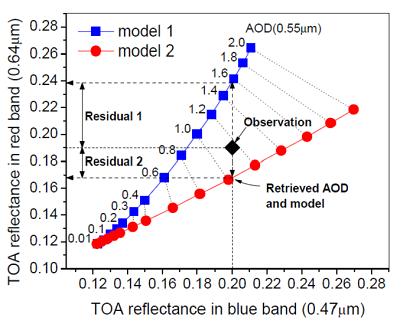 For
simplicity, the Figure plots the blue and red reflectances
from the LUT for two aerosol models (models 1 and 2) only. The numbers
shown along the curves represent the aerosol optical depth at 0.55 µm.
The aerosol optical depth increases from left to right leading to
monotonically increasing reflectances. The dotted lines connect
reflectances with the same aerosol optical depth. The large diamond
marks the observed blue and red reflectances, which in this example are
0.2 (blue) and 0.19 (red). Because the reflectance of a snow-free
surface is low in the blue band the blue reflectance is used to
retrieve the aerosol optical depth for each aerosol model in the LUT.
In the example shown, the retrieved AOD for model 1 is ~1.6, while that
for model 2 is ~1.1. Next, these AOD values are used to calculate
the red reflectances for each model leading to the values of ~0.24 and
~0.17 for models 1 and 2, respectively. These red reflectances are then
compared to the observed one, and the residuals for each model are
calculated. In the example, the residual for model 2 is the smallest
and thus the retrieved model is model 2 and the AOD is ~1.1. More
details are available in Laszlo et al. (2008).
For
simplicity, the Figure plots the blue and red reflectances
from the LUT for two aerosol models (models 1 and 2) only. The numbers
shown along the curves represent the aerosol optical depth at 0.55 µm.
The aerosol optical depth increases from left to right leading to
monotonically increasing reflectances. The dotted lines connect
reflectances with the same aerosol optical depth. The large diamond
marks the observed blue and red reflectances, which in this example are
0.2 (blue) and 0.19 (red). Because the reflectance of a snow-free
surface is low in the blue band the blue reflectance is used to
retrieve the aerosol optical depth for each aerosol model in the LUT.
In the example shown, the retrieved AOD for model 1 is ~1.6, while that
for model 2 is ~1.1. Next, these AOD values are used to calculate
the red reflectances for each model leading to the values of ~0.24 and
~0.17 for models 1 and 2, respectively. These red reflectances are then
compared to the observed one, and the residuals for each model are
calculated. In the example, the residual for model 2 is the smallest
and thus the retrieved model is model 2 and the AOD is ~1.1. More
details are available in Laszlo et al. (2008).
Validation with MODIS Aerosol Data
The ABI aerosol algorithm is being run routinely with MODIS reflectances as input. The resulting ABI aerosol retrievals are also routinely compared to the standard MODIS aerosol products. (Read more ...)
Validation with AERONET Aerosol Data
The ABI aerosol retrievals are evaluated by comparing the results to ground-observed data from the Aerosol Robotic Network (AERONET). ( Read more ...)
| Istvan Laszlo (Lead) | NOAA/NESDIS/STAR and University of Maryland at College Park |
|---|---|
| Mi Zhou | I. M. Systems Group Inc. (IMSG) |
| Pubu Ciren | I. M. Systems Group Inc. (IMSG) |
| Hongqing Liu | I. M. Systems Group Inc. (IMSG) |
| Shobha Kondragunta | NOAA / NESDIS / STAR |
| Qingzhao Guo | I. M. Systems Group Inc. (IMSG) |
| Alexei Lyapustin | University of Maryland Baltimore County and NASA Goddard Space Flight Center |
| Ping Yang | Texas A&M University |
References:
Kaufman, Y.J., Tanre, D., Remer, L.A., Vermote, E.F., Chu, A. Holben, B.N. Operational remote sensing of tropospheric aerosol over land from EOS moderate resolution imaging spectroradiometer. J. Geophys. Res. 102(D14), 17051-17067, 1997.
King, M.D., Kaufman, Y.J., Menzel, W.P., Tanre, D. Remote sensing of cloud, aerosol and water vapor properties from the Moderate Resolution Imaging Spectrometer (MODIS). IEEE Trans. Geosci. Remote Sens. 30, 2-27. 1992.
Laszlo I., P. Ciren, H. Liu, S. Kondragunta, J. D. Tarpley and M. D. Goldberg, 2008: Remote sensing of aerosol and radiation from geostationary satellites, Adv. Space Res., 41, 11, 1882-1893, doi: 10.1016/j.asr.2007.06.047
Remer, L.A., Kaufman, Y.J., Tanre, D., Mattoo, S., Chu, D.A., Martins, J.V., Li, R.-R., Ichoku, C., Levy, R.C., Kleidman, R.G., Eck, T.F., Vermote, E., Holben, B.N. The MODIS aerosol algorithm, products, and validation. J. Atmos. Sciences 62(4), 947-973, 2005.
Schmit, T.J., Gunshor, M.M., Menzel, W.P., Gurka, J. J., Li, J., Bachmeier, A.S. Introducing the next generation advanced baseline imager on GOES-R. Bull. Amer. Meteor. Soc. 86, 1079-1096, 2005.
Tanre, D., Kaufman, Y.J., Herman, M., Mattoo, S. Remote sensing of aerosol properties over oceans using the MODIS/EOS spectral radiances. J. Geophys. Res. 102(D14): 16971-16988, 1997.