
5th Symposium on the Impacts of an Ice-Diminishing Arctic
on Naval and Maritime Operations
Visualizations
Each of the topics linked below include images and animations that illustrate
the current state of Arctic ice.
The Arctic's Record Breaking Ice Melt - September 2012
 The sea ice in the
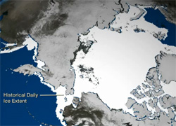
Arctic Ocean dropped below the previous all-time record set in 2007. This year also
marks the first time that there has been less than 4 million square kilometers
(1.54 million square miles) of sea ice since satellite observations began in 1979.
This animation shows the 2012 time-series of ice extent using sea ice concentration
data from the DMSP SSMI/S satellite sensor. The black area represents the daily
average (median) sea ice extent over the 1979-2000 time period. Layered over top
of that are the daily satellite measurements from January 1 - September 14, 2012.
A rapid melt begins in July, whereby the 2012 ice extents fall far below the
historical average. The National Snow and Ice Data Center will confirm the final
minimum ice extent data and area once the melt stabilizes, usually in mid-September. The sea ice in the
Arctic Ocean dropped below the previous all-time record set in 2007. This year also
marks the first time that there has been less than 4 million square kilometers
(1.54 million square miles) of sea ice since satellite observations began in 1979.
This animation shows the 2012 time-series of ice extent using sea ice concentration
data from the DMSP SSMI/S satellite sensor. The black area represents the daily
average (median) sea ice extent over the 1979-2000 time period. Layered over top
of that are the daily satellite measurements from January 1 - September 14, 2012.
A rapid melt begins in July, whereby the 2012 ice extents fall far below the
historical average. The National Snow and Ice Data Center will confirm the final
minimum ice extent data and area once the melt stabilizes, usually in mid-September.
Arctic Sea Ice Getting Thinner, Younger - October 2012
 Surface area isn't
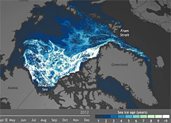
the only quality of the ice that is changing. Wind and ocean circulation patterns are
conspiring with a warmer climate to reduce the amount of year-round (multi-year) ice,
transforming the remaining ice into a younger, thinner version of its old self. The
loss of thick, melt-resistant, multi-year ice can easily become a self-reinforcing
process. When multi-year ice melts away--or when young ice fails to survive any melt
seasons--the ice that remains in the Arctic will be predisposed to melt quickly during
the following summer. Surface area isn't
the only quality of the ice that is changing. Wind and ocean circulation patterns are
conspiring with a warmer climate to reduce the amount of year-round (multi-year) ice,
transforming the remaining ice into a younger, thinner version of its old self. The
loss of thick, melt-resistant, multi-year ice can easily become a self-reinforcing
process. When multi-year ice melts away--or when young ice fails to survive any melt
seasons--the ice that remains in the Arctic will be predisposed to melt quickly during
the following summer.
Arctic Sea Ice Extent Sets Seasonal Record - September 2012
 The
National
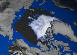
Snow and Ice Data Center announced today that on September 16, 2012 sea ice
extent dropped to 3.41 million square kilometers (1.32 million square miles).
This appears to have been the lowest extent of the year. In response to the
setting sun and falling temperatures, ice extent will now climb through autumn
and winter. However, a shift in wind patterns or a period of late season melt
could still push the ice extent lower. The minimum extent was reached three
days later than the 1979 to 2000 average minimum date of September 13. The
National
Snow and Ice Data Center announced today that on September 16, 2012 sea ice
extent dropped to 3.41 million square kilometers (1.32 million square miles).
This appears to have been the lowest extent of the year. In response to the
setting sun and falling temperatures, ice extent will now climb through autumn
and winter. However, a shift in wind patterns or a period of late season melt
could still push the ice extent lower. The minimum extent was reached three
days later than the 1979 to 2000 average minimum date of September 13.
Visual Highlights of 2012 Arctic Report Card - December 2012
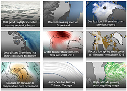 NOAA released the 2012
installment of the annual Arctic Report Card on December 5, 2012, as part
of the American Geophysical Union's fall meeting. You won't find these graphics
in the Report Card itself. This collection is a gallery of highlights based on
the report's major themes. It was developed by the NOAA Climate.gov team in
cooperation with Arctic Report Card authors and other Arctic experts. It
includes images depicting a record-breaking melt on Greenland, a lengthening
high-latitude growing season, and a record low spring snowcover in the
Northern Hemisphere. NOAA released the 2012
installment of the annual Arctic Report Card on December 5, 2012, as part
of the American Geophysical Union's fall meeting. You won't find these graphics
in the Report Card itself. This collection is a gallery of highlights based on
the report's major themes. It was developed by the NOAA Climate.gov team in
cooperation with Arctic Report Card authors and other Arctic experts. It
includes images depicting a record-breaking melt on Greenland, a lengthening
high-latitude growing season, and a record low spring snowcover in the
Northern Hemisphere.
(Graphics courtesy of the NOAA Environmental Visualization Lab
and NOAA Climate Watch)
2013 Symposium Information
Symposium Hosts
|


