STAR 2008 News & Events
Menghua Wang's Ocean Color Work Featured on NASA Remote Sensing Site
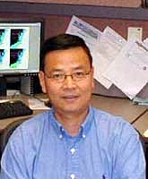 Recently, NASA's
Earth System Science Data and Services group included an article
on Menghua Wang's ocean color work in their publication
Sensing Our Planet: NASA Earth Science Research.
The article, entitled Cleaner
Water From Space details Wang's work using the MODIS
satellite sensor to detect, predict, and mitigate dangerous
algal blooms in large bodies of water.
From the article:
Wang sees a key role for near-real-time space
observations of lake water in the Taihu area and in other regions
trying to manage increasingly pressured water resources. Wang said,
"An image series like this will be very useful for local officials
in the management of water quality. We will know what's happening,
and when it's happening, and can give timely information to local
governments for water quality."
The NASA publication is available on the web.
Felix Kogan Wins Commerce Gold Medal Award for Scientific/Engineering Achievement
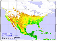 December 2, 2008 - Felix Kogan
recently received a Gold Medal Award from the U.S. Department of
Commerce at the 60th Annual Honor Awards Ceremony on November 18,
2008. He was honored for his work developing space-based, worldwide
drought early warning and vegetative health monitoring systems and
transferring the technology to users in more than ten nations. This
is the first operational use of NOAA's satellite instruments for
monitoring vegetative health and correctly portraying drought onset
and extent and an innovative use of a current NOAA Advanced Very
High Resolution Radiometer (AVHRR) sensor. The system has been used
to successfully monitor drought and affect agriculture and livestock
policy in the U.S., Kazakhstan, and Georgia (Caucasus). See
the website demonstrating his work here.
Workshop on Achieving Satellite Instrument Calibration for Climate Change (ASIC3)
For the most part, satellite observations of climate are not
sufficiently accurate to establish a climate record that is
indisputable and hence capable of determining at what rate the
climate is changing. Furthermore, they are insufficient for
establishing a baseline for testing long term trend predictions of
climate models. The reasons for this state of affairs are many, but
can be summed up in one all-encompassing statement: NOAA's
operational satellite systems have been focused on short term
weather observations, and NASA's research satellite systems have not
had the long term continuity needed for monitoring climate change.
As a result, highly accurate observations of decadal scale climate
trends are generally lacking. The Workshop on Achieving Satellite
Instrument Calibration for Climate Change (ASIC3), sponsored by
NIST, NASA, NOAA, NPOESS-IPO, and Space Dynamics Laboratory of Utah
State University, was organized to discuss the scientific issues
involved and develop recommendations to improve the situation. The
Workshop brought together experts in satellite instrument
calibration, metrology scientists from the U.S. and U.K. national
standards institutes, remote sensing specialists, and climate data
analysts. STAR has been responsible for editing and preparing the
Workshop Report, which has contributions from 29 scientists, and
will publish the printed hard copy version.
 Two overarching recommendations were developed at the workshop.
The first calls for a set of satellite benchmark missions to create
irrefutable records and calibrate other satellite sensors. This is a
new paradigm for measuring long-term global climate change. The
basic concept is to place in space a series of highly accurate
instruments, traceable to International Standards (SI), to measure
with fine spectral resolution the energy reflected and emitted by
the Earth. These instruments would not only provide reliable long-
term records in their own right, but would also serve as a reference
standard in space to calibrate other environmental satellite
sensors. This recommendation also calls for maintaining continuous,
overlapping missions for sea level, solar irradiance, and Earth
radiation budget. The second overarching recommendation calls for
establishing a U.S. National Center for Calibration (NCC). The NCC
would bring together NOAA's expertise in operational missions and
calibration/intercalibration of operational instruments, NIST's
leadership in measurement science and standards, and NASA's
capabilities in research missions and advanced calibration
techniques.
Noteworthy STAR contributors to this workshop and its report
include: Mitch Goldberg, Fuzhong Weng, and Changyong Cao were Lead
Authors of three chapters; Larry Flynn was a contributing author,
George Ohring edited the report, and Jerry Sullivan was a reviewer.
Mary Kicza was the Keynote Speaker at the Workshop and Al Powell
gave an invited talk on NOAA's calibration activities.
Final Report of ASIC3 Workshop (PDF, 3.6MB)
Special thanks to NOAA consultant George Ohring for writing this story.
Clouds from AVHRR Extended Project (CLAVR-x)
Launches New Google Earth Site Serving STAR-Generated AVHRR Imagery
Google Earth users can now access the most
recent high-quality satellite images generated at the University of
Wisconsin-Madison's Space Science and Engineering Center (SSEC). The
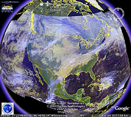 Clouds from AVHRR
Extended Project (CLAVR-x) is now using
Google Earth to display false-color imagery. Currently, the
site shows a pseudo true-color image which uses the AVHRR's 0.63,
0.86 and 10.8 micron channels to simulate what the eye would see
from space. In the future, this site will show other false-color
images to highlight cloud and surface properties as well imaging
derived products. The global coverage of the images will increase
when a new data server comes on line next year. The generation of the Google Earth images
was done by Amato Evan at UW/CIMSS and Andy Heidinger at STAR/CoRP/ASPB
with funding support from NOAA/NESDIS/STAR.
The Advanced Very High Resolution Radiometer (AVHRR) flies on the
NOAA POES and EUMETSAT METOP series of polar orbiting satellites.
The METOP/AVHRR provides global coverage with a resolution of 1
km. Data with a spatial resolution of 1 km is only available from
the NOAA POES instruments when recorded by a direct broadcast
station. We are using data from NOAA CLASS and this provides
direct-broadcast data from several sites in the conterminous USA
as well as Australia, Alaska and Hawaii. The site is updated
every time a new data-set is found.
Special thanks to Andy Heidinger, CoRP/ASPB, and Amato Evan and UW for their
work on this project.
STAR Personnel Win Gold and Silver Medal Recognition
at Annual Commerce Department Honor Awards Ceremony
At the 59th Annual Department of Commerce Honor Awards Program on
November 15, 2007, 7 different STAR scientists were honored with Gold or
Silver Medals. Paul S. Chang, Christopher W. Brown, and Kent H. Hughes
received Gold Medals for their efforts, while W. Paul Menzel, Kent H. Hughes,
Eileen Maturi, Xiangqian "Fred" Wu, and Cheng-Zhi Zou were honored with
Silver Medal recognition. The details of the awards and the work recognized
are detailed below.
Since 1949, the Department has granted honor awards in
the form of Gold, Silver, and Bronze Medals. The Gold and Silver Medals
are the highest and second highest honor granted by the Secretary for
distinguished and exceptional performance. The Bronze Medal is granted
by the head of an operating unit or Secretarial Officer for superior
performance. Honor Awards are granted in seven categories: Leadership,
Personal and Professional Service, Scientific/Engineering Achievement,
Organizational Development, Customer Service, Administrative/Technical
Support, or Heroism.
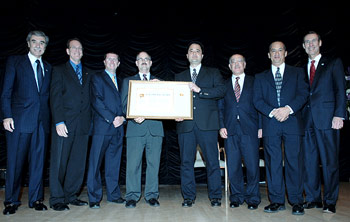
Among the STAR honorees, Paul Chang, Christopher Brown, Eileen Maturi, Xiangqian "Fred" Wu, and
Cheng-Zhi Zou were in attendance for the awards ceremony.
All of the official photos from the Medal Awards Ceremony can be viewed at
the DOC Press Photos site.
 Gold Medal for Leadership:
Paul S. Chang
Under Chang's leadership, the team cited for the award revolutionized
the analysis of tropical and extra-tropical systems, greatly enhancing the
accuracy of operational analyses, forecasts and warnings by using ocean
surface vector winds observed by QuikSCAT, a research satellite launched
in 1999.
Link to QuikSCAT.
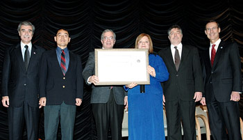
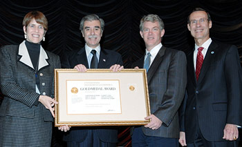 Gold Medal for Scientific / Engineering Achievement:
Team that included:
This team was honored for delivering operational satellite-derived
ocean biology products that support the need for forecasting and
monitoring coastal and ocean waters. These ocean biology products, such as
chlorophyll levels, help detect harmful algal blooms, assess regional
water quality, and locate suitable habitat for important marine species.
NOAA now relies daily on these products to provide information to its
customers involved in ocean and coastal management. these ocean biology
products are essential for NOAA to achieve its mission to maintain healthy
aquatic ecosystems.
Link: Ocean Color Data Sources, from
NOAA CoastWatch
 Silver Medal for Scientific / Engineering Achievement
W. Paul Menzel
Kent Hughes
Eileen Maturi
This team is recognized for introducing the first-ever hourly sea
surface temperatures (SST) from geostationary satellite measurements.
The product has revealed diurnal warming that is distinct from climate
trends, improvied offshore weather forecasts, and enabled more timely
services related to coral health, endangered species protection,
fisheries and marine mammal management, and other environmental
applications.
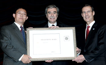 Silver Medal for Scientific / Engineering Achievement
Cheng-Zhi Zou
Dr. Zou is honored for developing an innovative and unique satellite
instrument intercalibration technique, which allowed data from several
NOAA satellites to be merged into a single consistent, long-term,
climate-quality record. He analyzed this 25-year record to determine the
global trends in atmospheric temperature. His result, a global
temperature increase of 0.20 degrees C per decade, is consistent with
trends observed from surface weather stations. His work adds
substantially to the robustness of observed atmospheric temperature
trends.
Link: Microwave Sounding Calibration and Trend
STAR Scientist Eric Leuliette Contributing Author of Chapter in Nobel-winning IPCC Report
 Dr. Leuliette has been a research oceanographer
with STAR in the Laboratory for Satellite Altimetry since January 2007.
He came to NESDIS/STAR from the Colorado Center for Astrodynamics
Research at the University of Colorado, where he was an assistant research
professor in the Department of Aerospace Sciences and Engineering. He
was recently recognized by NESDIS Administrator Mary Kicza along with
13 other NESDIS scientists for his contribution to the
Intergovernmental Panel on Climate Change (IPCC) reports. IPCC was
awarded the 2007 Nobel Peace Prize
along with former Vice President Al Gore
"for their efforts to build up and
disseminate greater knowledge about man-made climate change, and to
lay the foundations for the measures that are needed to counteract
such change".
As a member of Working Group 1 of the IPCC, Eric was a
contributing author and reviewer for the chapter "Observations:
Oceanic Climate Change and Sea Level" of the IPCC's Fourth
Assessment Report Climate Change 2007: the Physical Science Basis.
Eric contributed the latest sea level rise estimates from satellite
altimetry to the report. The chapter Dr. Leuliette contributed to and reviewed is available
at: https://www.ipcc.ch/report/ar4/wg1/.
The IPCC was established by the World Meteorological Organization
(WMO) and the United Nations Environment Programme (UNEP) to assess
scientific, technical and socio-economic information relevant for
the understanding of climate change, its potential impacts and
options for adaptation and mitigation. The IPCC report also provides
a list of all of the contributors (Annex II, pages 954-979).
More details about the IPCC and the Nobel Prize are on its official web site:
https://www.ipcc.ch/.
Figure 5.14 from Climate Change 2007,
Variations in Global Mean Sea Level, 1993 to mid-2001
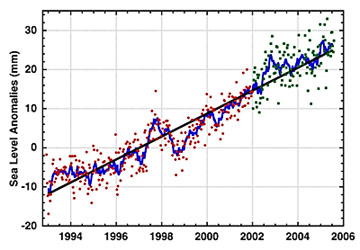 Variations in global mean sea level
(difference to the mean 1993 to mid-2001) computed from satellite
altimetry from January 1993 to October 2005, averaged over 65°S to 65°N.
Dots are 10-day estimates (from the TOPEX/Poseidon satellite in red and
from the Jason satellite in green). The blue solid curve corresponds to
60-day smoothing. Updated from Cazenave and Nerem (2004) and Leuliette
et al. (2004).
Past News Items

 Recently, NASA's
Earth System Science Data and Services group included an article
on Menghua Wang's ocean color work in their publication
Sensing Our Planet: NASA Earth Science Research.
The article, entitled
  December 2, 2008 - Felix Kogan
recently received a Gold Medal Award from the U.S. Department of
Commerce at the 60th Annual Honor Awards Ceremony on November 18,
2008. He was honored for his work developing space-based, worldwide
drought early warning and vegetative health monitoring systems and
transferring the technology to users in more than ten nations. This
is the first operational use of NOAA's satellite instruments for
monitoring vegetative health and correctly portraying drought onset
and extent and an innovative use of a current NOAA Advanced Very
High Resolution Radiometer (AVHRR) sensor. The system has been used
to successfully monitor drought and affect agriculture and livestock
policy in the U.S., Kazakhstan, and Georgia (Caucasus).
  Two overarching recommendations were developed at the workshop.
The first calls for a set of satellite benchmark missions to create
irrefutable records and calibrate other satellite sensors. This is a
new paradigm for measuring long-term global climate change. The
basic concept is to place in space a series of highly accurate
instruments, traceable to International Standards (SI), to measure
with fine spectral resolution the energy reflected and emitted by
the Earth. These instruments would not only provide reliable long-
term records in their own right, but would also serve as a reference
standard in space to calibrate other environmental satellite
sensors. This recommendation also calls for maintaining continuous,
overlapping missions for sea level, solar irradiance, and Earth
radiation budget. The second overarching recommendation calls for
establishing a U.S. National Center for Calibration (NCC). The NCC
would bring together NOAA's expertise in operational missions and
calibration/intercalibration of operational instruments, NIST's
leadership in measurement science and standards, and NASA's
capabilities in research missions and advanced calibration
techniques.
 Gold Medal for Leadership:
 Gold Medal for Scientific / Engineering Achievement:
 Silver Medal for Scientific / Engineering Achievement
 Silver Medal for Scientific / Engineering Achievement
 Variations in global mean sea level
(difference to the mean 1993 to mid-2001) computed from satellite
altimetry from January 1993 to October 2005, averaged over 65°S to 65°N.
Dots are 10-day estimates (from the TOPEX/Poseidon satellite in red and
from the Jason satellite in green). The blue solid curve corresponds to
60-day smoothing. Updated from Cazenave and Nerem (2004) and Leuliette
et al. (2004).