
Clear Sky Mask
Background
For many of the other products, it is important to determine which portions of the sky have clouds and which do not. More fornally, the Clear Sky Mask product provides the location of the cloud free vertical columns of the atmosphere. Hhile the official product is the Clear Sky Mask, the location of clouds is also important. This "Cloud Mask" is not a "product" because it is just the opposite values from the Clear Sky Mask. Expressed most simply, the Clear Sky Mask identifies every as clear or not clear. The cloud mask does not need to be a distinct product since every "not clear" location is a "cloud" and every "clear" location is "not a cloud".
Product Description
Cloud detection is the process of separating cloudy from clear pixels. It always involves assumptions of the radiometric characteristics of the clear and/or cloudy state and looking for departures from them. In the ACM, spectral, spatial and temporal tests are used to look for clouds by identifying pixels that do not exhibit the expected behavior of the clear-sky state. Each test described is applied to each pixel, resulting in a cloud/no cloud score, which is then used to decide whether a pixel is cloudy or clear.
Improvements and Benefits
The Clear Sky Mask algorithm will take advantage of the high spatial and temporal resolution of the GOES-R ABI visible, near-infrared, and infrared bands to automatically produce a cloud classification for each pixel: cloudy, probably cloudy, clear, or probably clear. This information will be used extensively by downstream level-2 product algorithms that require the state of cloudiness in each pixel. Products such as Land Surface Temperature (LST) and Sea Surface Temperature (SST), for example, can only be reliably computed for pixels that are totally cloud free. The Clear Sky Mask product can be used by the NWP community to identify which ABI pixel information should be assimilated for use in numerical weather prediction models.
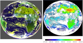
Fulldisk 0.63, 0.86, and 11μm false color image (left) from Meteosat-8/SEVIRI for 12:00 UTC on 10 August, 2006. Example of the Clear Sky Mask product (white areas in image on right), as generated by the GOES-R Clear Sky Mask algorithm using Meteosat-8/SEVIRI data on 10 August 2006 12:00 UTC.
How does it work? - Algorithm
The Clear Sky Mask uses 9 out of the 16 ABI spectral bands. Its cloud detection is based on spectral, spatial and temporal signatures. Most thresholds were derived from analysis of space-borne Lidar and current geostationary imager data. The ABI cloud tests where chosen to provide each algorithm a wide-range of cloud detection options. The ABI mask is designed to allow algorithms and users to ignore certain tests and to efficiently re-compute the cloud mask. In addition, the ACM design concept allows for easy expansion to include other tests as warranted. The current tests have their heritage in the cloud masks run operationally by NOAA, NASA and EUMETSAT.
See the GOES-R ATBD page for all ATBDs.
How are the results compared to existing data? - Calibration and Validation
CALIPSO cloud detection results are used to validate the ABI cloud detection; however they do not provide a direct measure of effects of cloud contamination on a product. Faults can be detected by comparing observed ABI infrared sea surface temperatures (IRSST) to those from the AMSR-E and TMI microwave imagers from Remote Sensing Systems, Inc. Since the microwave SST (MWSST) is insensitive to cloud presence, detected differences in IRSST and MWSST are a good basis for estimating cloud contamination effects.
A more technical validation presentation, (PDF, 10.83 MB) are also available