
Fractional Snow Cover Algorithm
Background
Snow mapping from the GOES family of environmental satellites has served as a critical and indispensible tool for operational water managers, weather forecasters and climate researchers since the 1970s. The dramatic leap forward in spaceborne imaging technology developed for GOES-R will provide unprecedented accuracy and precision in estimates of snow cover. The GOES-R Fractional Snow Cover (FSC) Algorithm provides a detailed, quantitative assessment of global snow cover and very high spatial resolution. In contrast to many other satellite-based snow cover products, the FSC is particularly accurate in areas of discontinuous snow cover and in transitions from snow-covered to snow-free land. Since FSC is based on spectral reflectances of snow in visible and near- visible wavelengths which vary with changes in grain size of the snow pack's surface, the FSC also retrieves snow grain size.
Product Description
The FSC calculates subpixel estimates of snow cover. FSC retrievals are xpressed as the fraction of the ABI pixel covered by snow (0.0 = no snow cover continuously through 1.0 = total snow cover).
Improvements and Benefits
The fractional Snow Cover algorithm uses GOES-R ABI spectral information in the visible and near-visible portion of the energy spectrum to retrieve sub-pixel fractional Snow Cover and grain size estimates via computationally efficient spectral mixture modeling. This product will support a number of operational applications that include: assimilation into NOAA's NOHRC snow model, as well as hydrologic forecasts and warnings, including river and flood forecasts, water management, snowpack monitoring and analysis, and climate studies.
How does it work? - Algorithm
With the single visible bands of previous GOES sensors, snow cover mapping was constrained to severe assumptions whereas we can now explore what we now know to be the rich variation in the spectral reflectance of snow. With the advent of the GOES-R Advanced Baseline Imager, the enhancement in spectral sampling coupled with frequent acquisitions will allow the more detailed characterization of fractional snow cover and the grain size of that fractional snow cover. Most satellite-based snow cover products provide a "binary" map, whereby each pixel is classified as either "snow" or "not snow". In contrast, the FSC algorithm is an optimized spectral mixture analysis that uses the broad spectrum from ABI to determine the fractional cover of snow, vegetation, and soils.
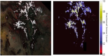
Example of the Snow Cover product (right figure) as generated by the GOES-R Snow Cover algorithm using MODIS data (left image) over the Colorado Rockies on 30 April 2007.
See the GOES-R ATBD page for all ATBDs.
How are the results compared to existing data? - Calibration and Validation
FSC is a quantitative, area representation of snow cover rather than a simple detection of presence somewhere in the area. Therefore, it is necessary to assess the spatial heterogeneity in the algorithm errors with validation data that have the capacity to reveal the distribution of snow cover at a scale finer than that of GOES-R and that can be coarsened to the scale of GOES-R. The primary validation datasets will be retrievals of snow cover from VIIRS (370 m) and Landsat Data Continuity Mission (LDCM) (29 m).
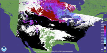
Fractional snow cover over North America using ABI proxy (MODIS, 5 bands) data
Additional validation will come in the form of binary validation with in situ measurements from cooperative observer networks and snow pillows and courses, numerical snow model state variables, and from the higher resolution satellite instruments. In particular, the NWS SNODAS model and the SNOTEL network will provide validation data.
GOES-R Snow Cover and Grain Size (GOESRSCAG) will be assessed in terms of their fractional accuracy, fractional precision, and stability over space and time.
A more technical validation presentation, (PDF, 21.67 MB) is also available