
Laboratory for Satellite Altimetry / Sea Ice and Polar Dynamics Science Team
Arctic snow depth from combined ICESat-2 and Cryosat-2 freeboard observations
As part of the CRYO2ICE campaign), the European Space Agency's radar altimeter, CryoSat-2 and NASA's laser altimeter, ICESat-2 have acquired complementary observations of Arctic sea ice since 2020. In this study, we compare ICESat-2 and CryoSat-2 freeboards to derive winter-time snow depth exploiting coincident laser/radar altimeter ground tracks as well as monthly gridded maps. CryoSat-2 freeboard from the ESA standard algorithm (ESA) and from the Alfred Wegener Institute (AWI) algorithm are combined with ICESat-2 freeboards to derive Laser/Radar (LaRa) snow depth over the Arctic Ocean. We averaged five years of monthly mean LaRa snow depths for each month and compared them with a modified Warren climatology. This could potentially produce an improved snow depth climatology that reflects the recent Arctic sea ice environment. Five years of winter months (November to April) of CryoSat-2 Baseline-E L1A/L2 and ICESat-2 ATL07/10 release 6 data from Nov 2018 to April 2023 were used in this study. We also used AWI CryoSat-2 freeboard data for the same period. We used sea ice concentration data from the National Snow and Ice Data Center (NSIDC) to define sea ice boundary and sea surface type data from OSI SAF to determine first-year or multi-year ice. Figure 1 describes the snow-covered sea ice over the Arctic.
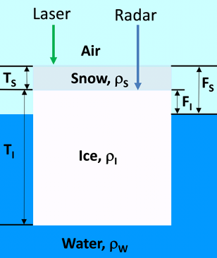
Figure 1. Snow-covered sea ice. Freeboard (FS) is defined as the total height of the snow cover and sea ice above sea level. TS is snow depth. FI is snow/ice interface height above sea level. TI is sea ice thickness. The snow, ice, and water densities are ρS, ρI, and ρW, respectively.
In this study, we applied the widely used assumptions that the ICESat-2 laser signal is scattered back from the air/snow interface and that the CryoSat-2 Ku-band radar signal is scattered back from snow/ice interface for sea ice floes. For open water and thin ice, both ICESat-2 and CryoSat-2 signals are assumed to scattered back from air/water and air/ice interface. We derived snow depth (LaRa) over the Arctic from the differences of ICESat-2 (laser) and CryoSat-2 (radar) freeboards:
LaRa ≡ FS – FI = (FS–FR) cs/c
The sea ice freeboard at snow/ice interface is: FI = FR + (c/cs – 1) TS
(c/cs-1)TS is speed of light correction in snow. Based on Tiuri et al., 1984, speed of light in snow layer can be calculated with: cs = c / √(1 + 1.7 ρs + 0.7 ρs2)
ρs is assumed not varying with snow depth and changing with time and location as in the Warren climatology.
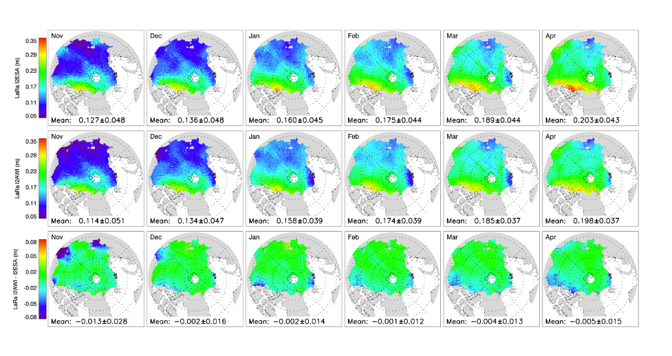
Figure 2. The derived LaRa snow depths from ICESat-2, CryoSat-2 ESA freeboard (I2ESA) and from ICESat-2, CryoSat-2 AWI freeboard (I2AWI), and their differences (I2AWI - I2ESA).
Data Product and Data Access
Product data files are in NetCDF format. LaRa snow depth in each month (month number is in the file name) from November to April are in a file. I2ESA and I2AWI are in different files. Each file has three parameters:
grid_lat(304, 448)    Latitude (degrees)
grid_lon(304, 448)    Longitude (degrees)
LaRa_sd_5yr(304, 448) LaRa snow depth (meters)
Acknowledgment: Users are free to use the information hosted on this site in their
research, provided credit is given to the NOAA / NESDIS Center for Satellite Applications and
Research (STAR) Laboratory for Satellite Altimetry (LSA). Users are also asked to cite the
following publication whenever these data are used:
Arctic snow depth and sea ice thickness from combined ICESat-2 and CryoSat-2 freeboard
observations by Donghui Yi, Sinead L. Farrell, Laurence Connor, Alejandro Egido, Christopher
Buchhaupt, Dexin Zhang, Eric Leuliette, and John Kuhn. In review at Annals of Glaciology
Date TBD.