
Laboratory for Satellite Altimetry / Sea Ice and Polar Dynamics Science Team
Project Background
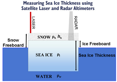
Measuring Sea Ice Thickness Using Satellite Laser and Radar Altimeters
By measuring the elevation of a sea ice floe above the local sea surface, sea ice freeboard may be determined. Precise estimates of local sea surface elevation acquired within leads are critical to generate a reference profile of sea surface height. Subtraction of the reference sea level from the elevation of nearby ice floes yields estimates of ice freeboard.
Over sea ice, laser altimeters measure the elevation of the sea ice plus any snow cover on top (known as the "snow freeboard"), whereas radar altimeters measure the elevation of just the sea ice (known as the "ice freeboard"). This is due to different penetration depths of laser and radar altimeters into the snow.
Sea ice freeboard can be converted into thickness by assuming that the ice floe is in hydrostatic equilibrium and applying Archimedes' principle.
The relative heights of the ice freeboard (hf), ice draft (hd), and snow load (hs) are balanced and using estimates of snow (ρs), ice (ρi) and water (ρw) density, the ice thickness (hi) can be calculated using the equation below. Uncertainties in the depth of the snow on the ice as well as the penetration of the radar signal into the snow surface are the main sources of error.
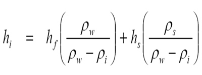
Ice Thickness Equation
References
- More details on the radar altimetry measurement system.
- ESA and CLS have created a tutorial on satellite radar altimetry.