Laboratory for Satellite Altimetry / Sea Ice and Polar Dynamics Science Team
Sea Ice Surface Elevation Distribution
The sea ice surface elevation distribution product is derived using Airborne Topographic Mapper (ATM) L1B data collected over the Arctic Ocean during NASA's Operation IceBridge (OIB) Spring campaigns between 2009 and 2019. An exponentially modified Gaussian (EMG) distribution is used to fit the surface elevation probability density function (PDF). The characteristic function of the EMG distribution can be integrated in the modeling of radar altimeter waveforms.
To build the elevation distribution, the ATM data are grouped into segments spanning 1.5 km in the along-track direction of the flight-line. Sea ice surface elevation PDF is calculated for each 1.5 km segment. Cluster analysis is used to distinguish floe heights from leads heights. Floe heights are then used for PDF calculations. The calculated PDF is then fitted to an EMG distribution model.
The EMG distribution with mean = μe + 1/λ and variance = σe2 + 1/λ2 is defined as
EMG(x)=(λ/2) e((λ/2)(2μe + λσe2-2x)) erfc((μe + λσe2-x)/(√2 σe )).
where erfc is the complementary error function defined as erfc(x) = 1-erf(x) = (2/√π) ∫x∞e(-t2) dt.

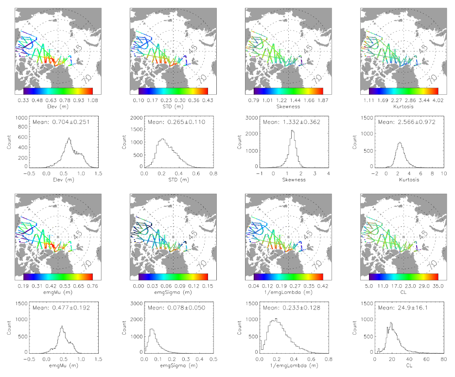
Figure 1. The elevation, standard deviation of elevation, skewness, kurtosis, μe (emgMu), σe (emgSigma), and 1/λ (emgLambda) of the 1.5 km sections of 2014. Measurement noise is removed from the standard deviation of elevation.
Data Product and Data Access
Eight parameters are included in the sea ice surface elevation distribution product (e.g., Figure 1). These include four statistical parameters calculated from surface elevation measurements (mean, STD, skewness, kurtosis), three EMG model parameters from fitting to the elevation PDF (μe, 1/λ, σe), and the correlation length (CL) determined from autocovariance function calculations.
Product data files are in NetCDF format. Files are organized such that each elevation distribution product data file corresponds to an OIB ATM data file. The parameters included in an individual record include:
Data file variablesA single record of a 1.5 km segment within a netDCF file includes the variables:
		mlat 	– mean latitude [degrees]
		mlon 	– mean longitude [degrees]
		melev 	– mean elevation [meters]
		std 	– standard deviation of elevation [meters]
		skewness 	– skewness
		kurtosis 	– kurtosis
		count 		– number of ATM footprints
		pdf_xx 	– x-axis of elevation PDF
		pdf 		– elevation pdf [counts]
		Pdf_exGaussian - emg fitting of elevation pdf [counts]
		exGaussian_mu - emg fitting parameter mu [meters]
		exGaussian_sigma - emg fitting parameter sigma [meters]
		exGaussian_lamda - emg fitting parameter lamda [meters]
		exGaussian_amplitude - emg fitting parameter amplitude [counts]
		ACF_xx 	- x-axis of autocorrelation function [meters]
		ACF 		- Autocorrelation function [meters^2]
		CL 		– correlation length [meters]
		Lead_count 	– number of lead ATM footprints
		Meas_noise 	– ATM measurement noise [meters]
Acknowledgment: Users are free to use the information hosted on this site in their research, provided credit is given to the NOAA / NESDIS Center for Satellite Applications and Research (STAR) Laboratory for Satellite Altimetry (LSA). Users are also asked to cite the following publication whenever these data are used:
Yi, D., Egido, A., Smith, W. H. F., Connor, L., Buchhaupt, C., and Zhang, D. (2022) Arctic Sea-Ice Surface Elevation Distribution from NASA’s Operation IceBridge ATM Data, Remote Sensing, 2022, 14, 3011. doi:10.3390/rs14133011.Data access:
- https://www.star.nesdis.noaa.gov/data/socd3/lsa/SeaIceProducts/Airborne/IceBridge/SurfaceTopography/
Points of Contact: Donghui.Yi@noaa.gov (NOAA Affiliate) and Laurence.Connor@noaa.gov (NOAA Federal)
End Users
The surface elevation distribution data product is useful because it provides the characteristic function of the EMG distribution can be integrated in the modeling of radar altimeter waveforms. This is essential to the radar altimeter retracking process over sea ice for the retrieval of sea ice surface elevation. The product forms a foundation for improved characterization of sea ice surface roughness, freeboard and thickness in high-resolution sea ice models. It also provides a basis for calibration and validation for sea ice surface roughness, freeboard, and thickness measurements derived from other satellite missions such as ASCAT, Sentinel-3A/B, CryoSat-2, and ICESat-2. End users of this sea ice data product include modelers and academia conducting basic research.
