
Laboratory for Satellite Altimetry / Sea Ice and Polar Dynamics Science Team
Snow Depth on Arctic Sea Ice
Snow depth on Arctic sea ice is derived from Center for Remote Sensing of Ice Sheets (CReSIS) Frequency Modulated Continuous Wave (FMCW) snow radar data acquired during the late winter months of March, April, and May during NASA's annual Operation IceBridge (OIB) airborne campaigns in the Arctic.
Snow depth is calculated using a wavelet-based algorithm described in Newman et al., (2014) to identify the air-snow and snow-ice interfaces from snow radar echograms (Figure 1).
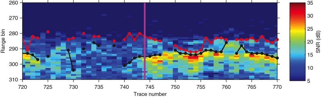
Figure 1. Snow radar echogram segment from a March 2011 survey over sea ice in the Beaufort Sea, showing the detection of the air-snow interface (red-dotted line) and snow-ice interface (black-dotted line) using a wavelet-based algorithm (Newman et al., 2014).
Data Product and Data Access
The NOAA Wavelet (NOAA WAV) Snow Depth on Arctic Sea Ice is derived from snow radar measurements acquired during annual, low-altitude NASA OIB airborne surveys over Arctic sea ice. Snow radar measurements were acquired between March and May, 2009-2012, 2014 and 2015. Snow depth statistics are computed for 10 km along-track segments, for each aircraft flight line.
Acknowledgment: Users are free to use the information hosted on this site in their research, provided they cite the following publication whenever these data are used: Newman, T., S. L. Farrell, J. Richter-Menge, L. N. Connor, N. T. Kurtz, B. C. Elder, and D. McAdoo (2014), Assessment of radar-derived snow depth over Arctic sea ice, J. Geophys. Res. Oceans, 119, 8578-8602, doi:10.1002/2014JC010284.
Data access:
- https://www.star.nesdis.noaa.gov/data/socd3/lsa/SeaIceProducts/Airborne/IceBridge/SnowDepth/
- NCEI Archive
Point of Contact: Laurence.Connor@noaa.gov
End Users
The snow depth data product can be used to improve the characterization of sea ice freeboard and ice thickness in high-resolution sea ice models. It also provides a basis for calibration and validation for snow depth and sea ice thickness measurements derived from satellite missions such as CryoSat-2 and ICESat-2. End users of this sea ice data product include modelers and academia conducting basic research.