Operational vs. Reprocessed Satellite Data
Operational Satellite Data
Level 2 satellite products, generated using scientific algorithms, have latency requirements. This means the data must be generated and made available to users within a specific time period after the satellite overpass, typically 15 minutes to 3 hours, depending on the product. This fast latency is necessary so operational users, such as weather forecasters, can have quick access to the data. Satellite data files generated in this fast latency process are termed operational.
Reprocessed Satellite Data
During the course of a satellite sensor’s multi-year lifetime, its Level 2 product algorithms undergo periodic updates and improvements. These routine algorithm changes translate into inconsistencies in the associated operational data; older data may be less accurate or have less coverage compared to the latest data.
At a certain point, an algorithm will reach a maturity level such that its current operational data are substantially different than past data, thereby making accurate long-term data analysis difficult. To generate a consistent dataset for long-term analysis, the full or partial time series of Level 2 products are re-generated by running Level 1b data through the most recent version of the Level 2 algorithm. Satellite data files generated in this way are termed reprocessed.
A recent illustrative example is reprocessing of Sentinel-5P (S5P) TROPOMI NO2 data for the period May 1, 2018 to November 14, 2021. This reprocessing was done to create a consistent NO2 dataset for analysis of trends related to the impacts of COVID-19 shutdowns on air pollution. Reprocessing was necessary because updates to the TROPOMI NO2 algorithm in December 2020 and July 2021 caused systematic increases in retrievals of tropospheric column NO2 in the operational data. As a result, any analysis of TROPOMI NO2 operational data over a time range that began prior to December 2020 and ended after July 2021 would show jumps in observed NO2 that were artifacts of the algorithm updates, not actual changes in atmospheric NO2.
Reprocessing of VIIRS L2 Aerosol Products
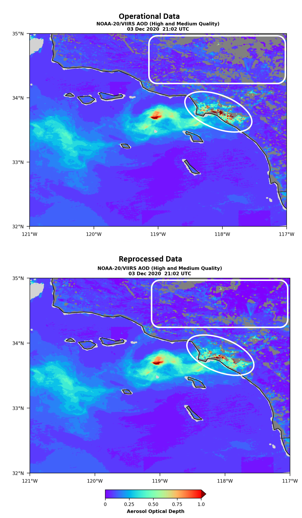
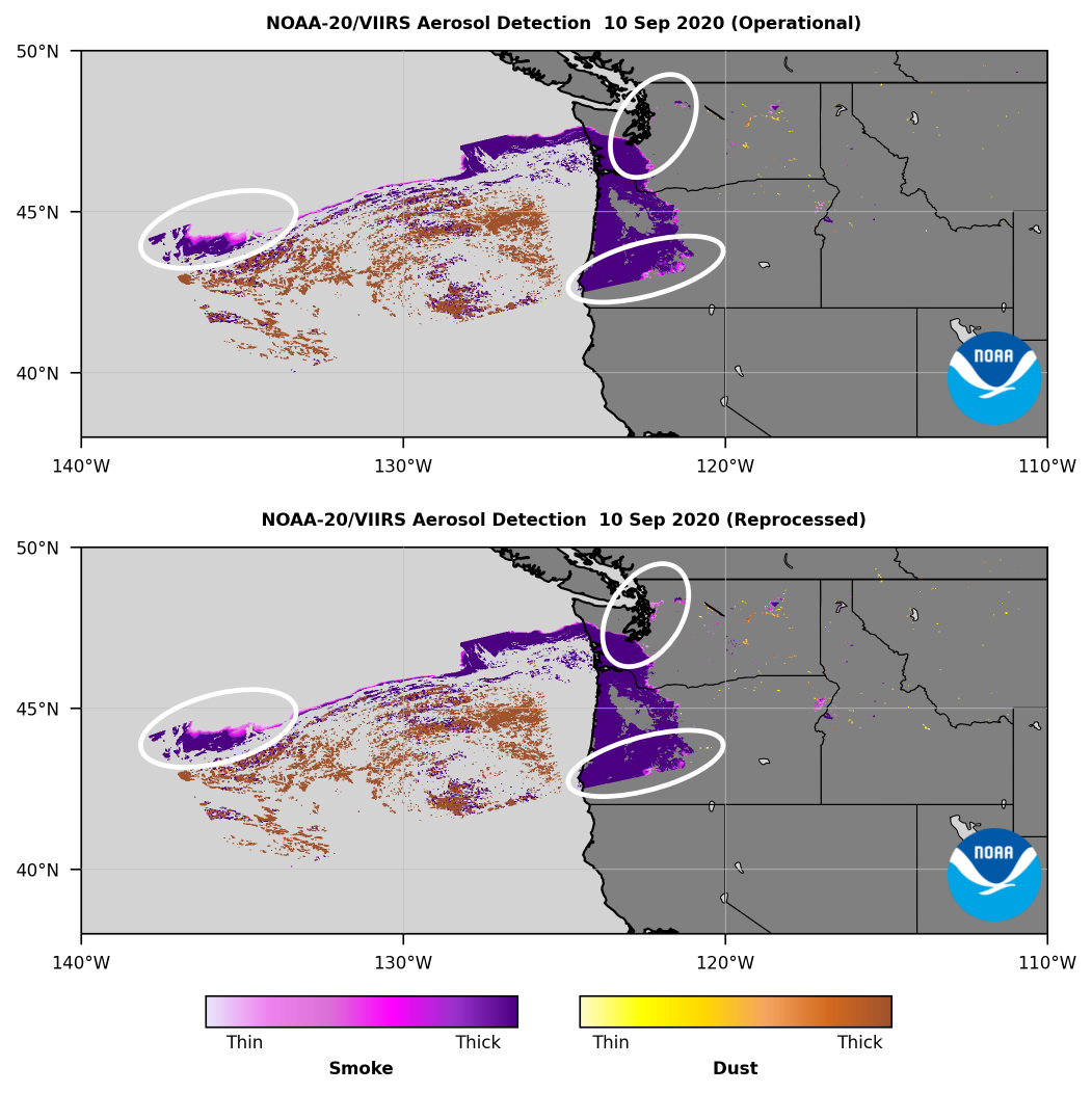
NOAA's VIIRS L2 aerosol products, Aerosol Optical Depth (AOD) and Aerosol Detection Product (ADP), have recently been reprocessed using the latest versions of the Enterprise Processing System (EPS) algorithms. The “Enterprise” approach to NOAA algorithms optimizes processes and use of resources: the same method (physics and assumptions) and its realization (software) are applied to retrieve AOD or ADP regardless of the source of satellite radiances. This means that for a given L2 product, like AOD or ADP, there is one scientific algorithm and software to process L1b data and generate aerosol product outputs, and it can be applied to different satellite sensors, each having different spectral bands, spatial resolution, pixel size, geographical coverage, and temporal resolution. In short, instead of having slightly different algorithms for each individual sensor, EPS algorithms are satellite/sensor agnostic.
What does this mean for end users? If you are doing any kind of long-term trends analysis, be sure to use the reprocessed data, available from the JPSS NODD on Amazon Web Services for SNPP VIIRS data and NOAA-20 VIIRS data. You will notice improvements in the coverage and accuracy of the reprocessed data compared to the operational data for the same granule; examples are shown below for VIIRS AOD and ADP (click images to open full size versions).