STAR - Global Vegetation Health Products: VIIRS Bands
Visible/Infrared Imager/Radiometer Suite (VIIRS)
The Visible Infrared Imager Radiometer Suite (VIIRS) will provide advanced imaging and radiometric capabilities aboard the NPOESS Preparatory Project spacecraft and future next-generation weather satellites.
VIIRS will combine the radiometric accuracy of the Advanced Very High Resolution Radiometer (AVHRR) currently being flown on the NOAA polar orbiters with the high spatial resolution (0.65 km) of the Operational Linescan System (OLS) flown on DMSP. A key part of the weather forecasting data chain, VIIRS will provide highly detailed imagery of global storm patterns. VIIRS multi-band imaging capabilities also support the acquisition of high-resolution atmospheric imagery for a variety of other applied products including land cover, vegetation health, detection of fires, smoke, and atmospheric aerosols. It will provide imagery of clouds under sunlit conditions in about a dozen visible and infrared bands, with nighttime applications as well.
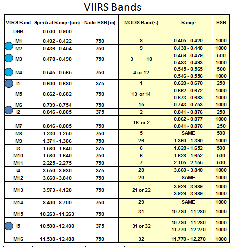
Visible and near infrared channels (I1 : 0.64 um, I2 : 0.86 um) will be used to produce the Normalized Difference Vegetation index(NDVI) and infrared band (I5 : 11.0 um) can be used to produce brightness temperature (BT). Combination of NDVI and BT will be used to monitor the Vegetation Health (VH).